Aliwagwag Falls

Discover the 10 Most Breathtaking Philippines Waterfalls: Nature’s Best Kept Secrets

Discover the 10 Most Breathtaking Philippines Waterfalls: Nature’s Best Kept Secrets

When it comes to natural beauty, the Philippines never disappoints. Among the most breathtaking sights are the country’s spectacular waterfalls. From the thunderous cascades hidden deep in the rainforests to serene multi-tiered falls perfect for a refreshing dip, Philippines Waterfalls should definitely top your bucket list. These waterfalls don’t just offer scenic views, they’re gateways to adventure, culture, and eco-tourism all wrapped into one.

In this blog, we’ll take you on a Philippines waterfalls tour of ten of the most famous and awe-inspiring falls in the country. We’ll explore everything from how to get there, what to expect upon arrival, and all the insider tips for a trip you won’t forget.

Tinuy-an Philippines Waterfall
Tinuy-an Falls Photo By Billy Palatino @Wikipedia

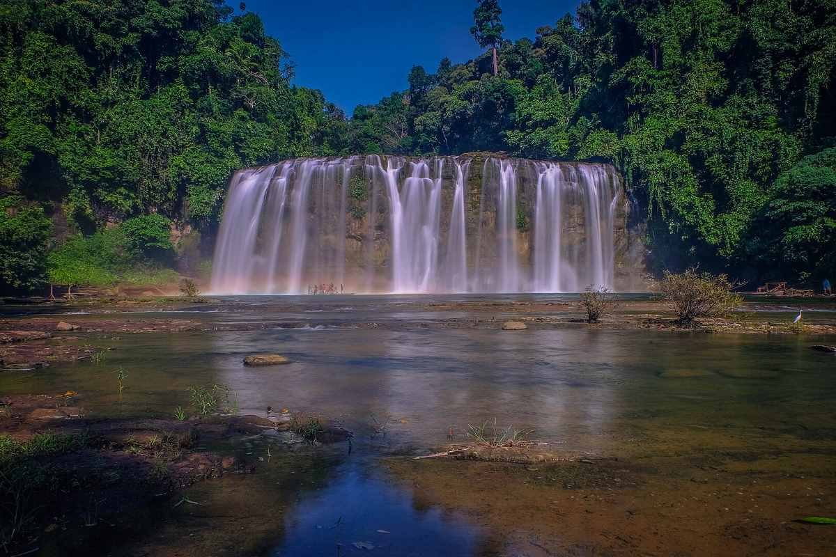
1. Tinuy-an Falls: The Little Niagara of the Philippines


A Majestic Wall of Water Awaits You!

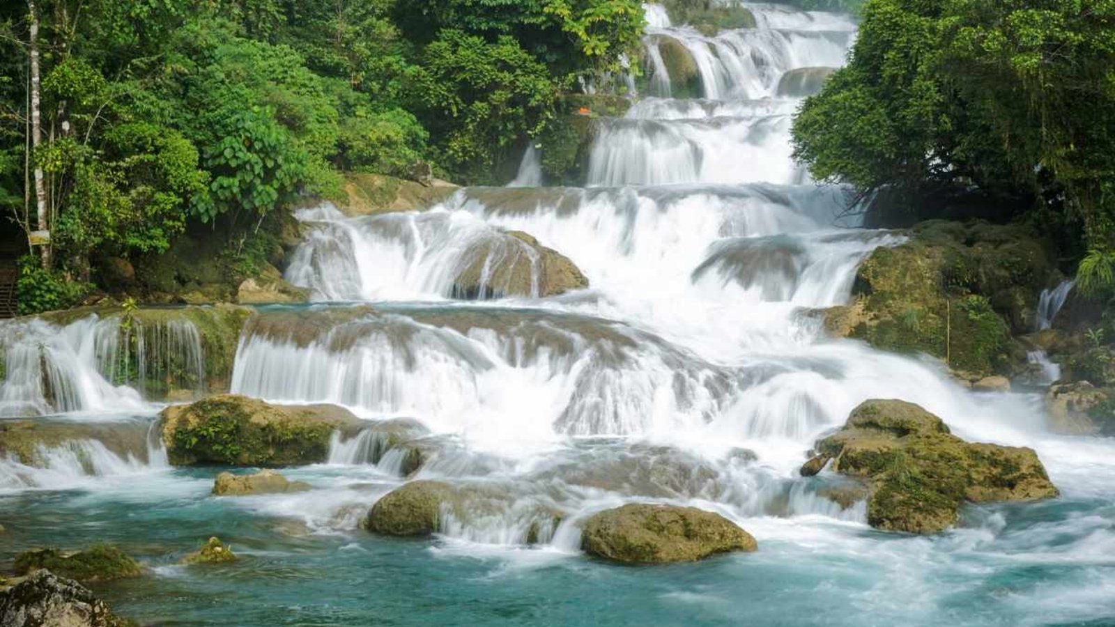
Picture this: A massive wall of water cascading down a 95-meter wide, 55-meter tall rock face, creating a curtain-like effect. That’s Tinuy-an Falls, often dubbed as the “Little Niagara Falls of the Philippines.” Located in Bislig, Surigao del Sur, this four-tiered beauty is best admired from a bamboo raft that takes you right up to its base. The spray of water, the lush greenery, and the sheer size of Tinuy-an Falls will leave you mesmerized. Truly, a Philippines Waterfalls wonder!

How to Get There: From Butuan City, it’s a 4-hour bus ride to Bislig, then another 45-minute habal-habal (motorcycle taxi) ride to the entrance. The road gets rough, so be prepared for a bumpy adventure! Once at the site, a 10-minute walk brings you to the viewing area.

Best Time to Visit: June to November, during the rainy season, ensures the falls are at their fullest. Bring a waterproof jacket and wear shoes with good grip for the walk to the falls.


What You Need to Know Before You Go: Entry Fees and Amenities

Tinuy-an Falls is well-developed for tourists, with picnic areas, cottages for rent, and basic restroom facilities. There is an entrance fee of around PHP 50.00, and bamboo rafts can be rented for PHP 150.00. Swimming is allowed, and lifeguards are usually on-site, but always follow local safety regulations. Wear water shoes to protect your feet when swimming or walking in the shallow areas, and avoid littering—locals are strict about waste management.


Snap the Perfect Shot: Scenic Spots and Photography Tips

Head to the viewing deck on the third tier for panoramic shots of this spectacular Philippines waterfall. For a more intimate feel, bring a waterproof camera on the raft and snap photos right in the heart of the falls. While you’re there, don’t miss nearby attractions like the Enchanted River, known for its clear blue waters.

Kaparkan Falls
Kaparkan Falls

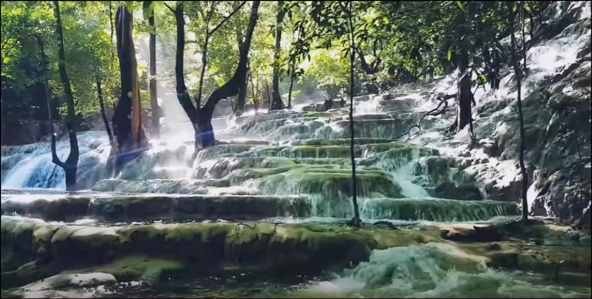
2. Kaparkan Falls: A Hidden Terraced Wonder


Cascading Terraces in the Middle of Abra’s Forests

Kaparkan Falls, also known as Mulawin Falls, is truly a hidden gem of the Philippines waterfalls. Unlike the typical vertical waterfall, Kaparkan features cascading limestone terraces that look like nature’s version of rice paddies, filled with refreshing water. It’s tucked deep in the forests of Tineg, Abra, making it one of the most secluded Philippines Waterfalls on this list.

How to Get There: From Bangued, Abra, you’ll need a 4×4 vehicle to traverse the off-road jungle trails. The trip can be bumpy and difficult, especially during the rainy season. Once the road ends, there’s a short hike to reach the falls.

Best Time to Visit: Visit Kaparkan Falls during the rainy season, from August to September, when the terraces are filled with water. Visiting in summer will be disappointing as the falls dry up.


A Unique Experience: Permits, Fees, and Amenities

As Kaparkan Falls is still relatively undeveloped, basic amenities are scarce. You’ll need to bring your own food and water. There’s an environmental fee of PHP 300.00, which contributes to conservation efforts. Swimming is allowed, but be careful on the slippery limestone. Always respect the site and avoid leaving trash behind. The locals take pride in maintaining its pristine condition, and visitors are encouraged to do the same.


Nearby Attractions: Hidden Historical Gems and Photo Spots

While in Abra, check out the scenic Tangadan Tunnel, an iconic stone tunnel that will give your Instagram some serious vintage vibes. For photography at the falls, focus on wide-angle shots to capture the full expanse of the limestone terraces.

Kawasan Falls
Kawasan Falls Photo By Andrewhaimerl @Wikipedia

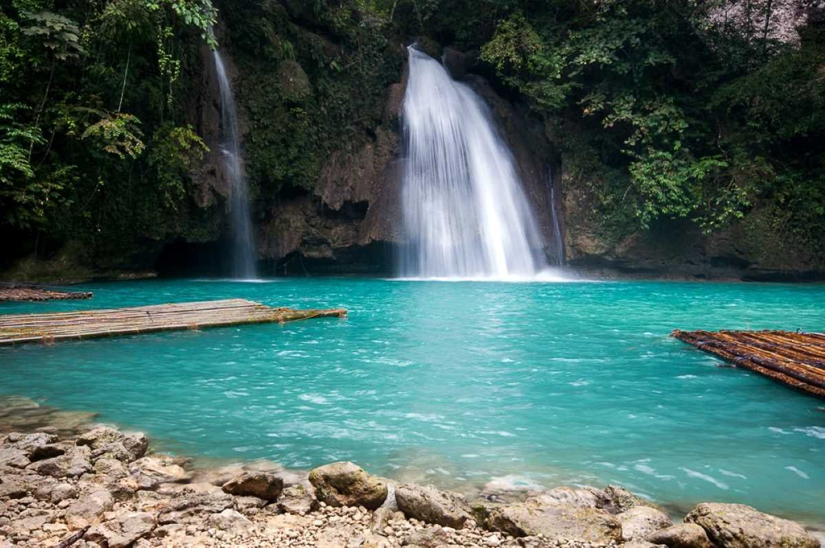
3. Kawasan Falls: The Jewel of Philippines Waterfalls

Azure Pools and Adventure Await at Kawasan Falls

Kawasan Falls in Badian, Cebu, is the epitome of tropical paradise. The waterfall drops into an unbelievably turquoise pool, perfect for swimming. The site is also famous for canyoneering—a must-try for adrenaline junkies!

How to Get There: From Cebu City, it’s a 3-hour bus ride to Badian, followed by a 15-20 minute walk along a scenic trail that winds through the jungle. It’s an easy hike, suitable for all ages.

Best Time to Visit: Summer months (March to May) are the best, with clear skies and warm temperatures. However, the falls can get crowded during these times, so aim for early mornings or weekdays.


Safety and Comfort: Fees, Facilities, and Rules

Kawasan Falls is well-developed with restaurants, cottages, and raft rentals. The entrance fee is PHP 45.00. For canyoneering, guides are required, and prices start at around PHP 1,500.00, which includes equipment. Swimming is allowed in all pools, but always check the water depth before jumping in. Wear a life jacket, especially when canyoneering, and follow local guides for safety instructions.


Adventure and Beauty: Photography Tips and Nearby Spots

For the best photos, hike up to the third level of the falls where fewer tourists venture, and snap shots of the lush surroundings from the bamboo rafts. When you’re done at the falls, visit nearby Moalboal for incredible snorkeling with sea turtles!

Aliwagwag Falls
Aliwagwag Falls Photo By Andrew Gil Desabelle @Wikipedia

4. Aliwagwag Falls: The Tallest Waterfall in the Philippines


Towering Heights and Multi-Tiered Cascades Await!

Aliwagwag Falls in Cateel, Davao Oriental, is a masterpiece of nature. With over 130 cascading tiers, it’s the tallest waterfall in the Philippines. The water rushes down in a series of drops, creating natural pools perfect for a quick dip. The falls are framed by dense jungle, giving the whole area an ethereal, untouched feel.

How to Get There: From Davao City, it’s a 6-hour bus ride to Cateel, followed by a 15-minute habal-habal (motorcycle taxi) ride. The journey is long, but the sight of Aliwagwag Falls makes it all worthwhile.

Best Time to Visit: The falls are stunning year-round, but to see them in their full glory, visit between December and May.


Entrance Fees, Permits, and Safety Rules

There is an entrance fee of around PHP 100.00. The site offers picnic huts and restrooms, but amenities are basic. Swimming is allowed, but be cautious as the rocks can get slippery. There’s also a zipline for adventure seekers! Visitors are encouraged to respect local customs—no loud music and no littering. The locals practice strict environmental conservation measures.


Beyond Aliwagwag: Hidden Wonders Nearby

While you’re in Cateel, make sure to visit the nearby Cateel River and the majestic Mt. Hamiguitan Range Wildlife Sanctuary. For photography, focus on close-ups of the multi-tiered cascades or wide shots of the whole waterfall structure.

Asik Asik Falls
Asik Asik Falls Photo By Jyppe A. Quidores @Wikipedia

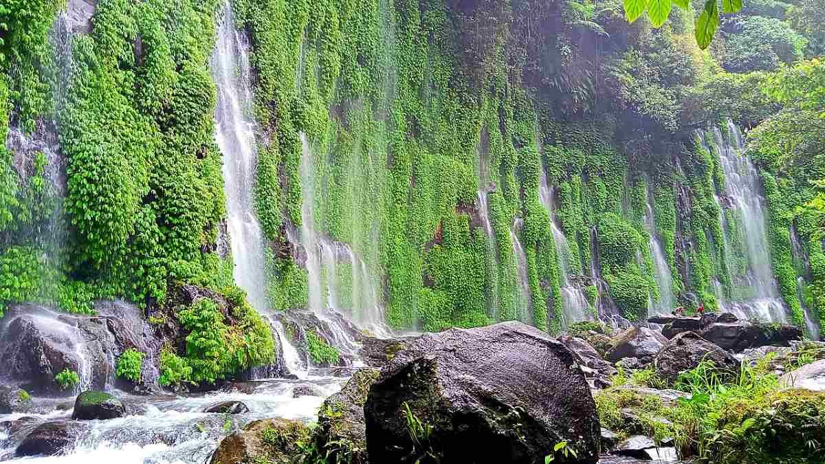
5. Asik-Asik Falls: A Curtain of Nature’s Magic


A Hidden Green Curtain in Cotabato

Tucked in the remote mountains of Alamada, North Cotabato, Asik-Asik Falls looks like a green curtain of vines with water streaming down the cliffside, creating a fairytale-like atmosphere. The absence of a river feeding into it adds to its mystery.

How to Get There: From Cotabato City, take a 2-hour bus ride to Midsayap, followed by a habal-habal (motorcycle taxi) ride to the jump-off point. Be prepared for a strenuous 30-minute trek down to the falls.

Best Time to Visit: Asik-Asik is best visited during the rainy season, from June to October, when the falls are at their most impressive.


Facilities, Fees, and Safety Information

There is a small entrance fee of PHP 30.00. The site is relatively underdeveloped, so bring your own food and water. There are no changing rooms or restrooms, so plan accordingly. Swimming is allowed, but be careful of the slippery rocks.


Nearby Attractions: Eco-Tourism and Hidden Gems

While in the area, explore the quiet town of Alamada and its rich cultural heritage. For the best photo ops, go for wide-angle shots to capture the entire curtain-like waterfall with the lush greenery behind.

Daranak Philippines Waterfalls
Daranak Falls Photo By Wazzup Carl @Wikipedia

6. Daranak Falls: The Perfect Weekend Getaway


A Quick Escape to Nature in Rizal Province

Daranak Falls is an easy escape for those based in Metro Manila. Located in Tanay, Rizal, this Philippines waterfall plunges into a cool basin surrounded by verdant greenery, offering a refreshing respite from the city’s hustle and bustle.

How to Get There: From Manila, Daranak Falls is about a 2-hour drive. Parking is available at the site, and the walk to the falls is a short 5-minute stroll.

Best Time to Visit: The best time to visit is from June to October when the falls are full, but it can get crowded during weekends, so plan your visit on a weekday if possible.


Fees, Facilities, and Safety Tips

There is an entrance fee of PHP 50.00, and the site has picnic areas, restrooms, and parking. Swimming is allowed, but lifeguards are on duty, and the pool depth varies, so always be cautious. Daranak Falls has strict waste management rules—no littering allowed. Make sure to pack out everything you bring in.


Nearby Attractions: Scenic Photo Spots and Adventure Options

For nearby adventures, try visiting Batlag Falls, a smaller but equally beautiful waterfall just a short hike away. Capture photos during golden hour for the best lighting, and frame your shots with the lush greenery surrounding the falls.

Limunsudan Falls
Limunsudan Falls Photo By Floresa816 @Wikipedia

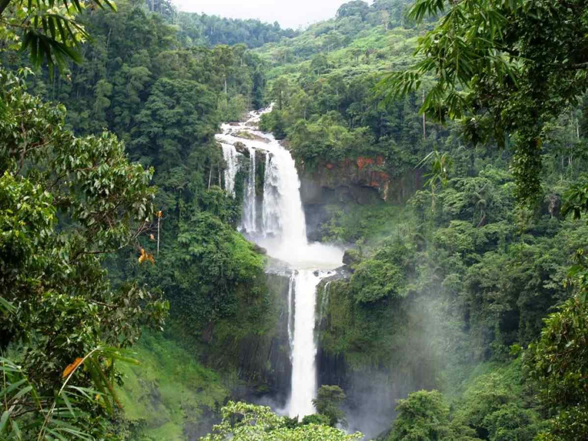
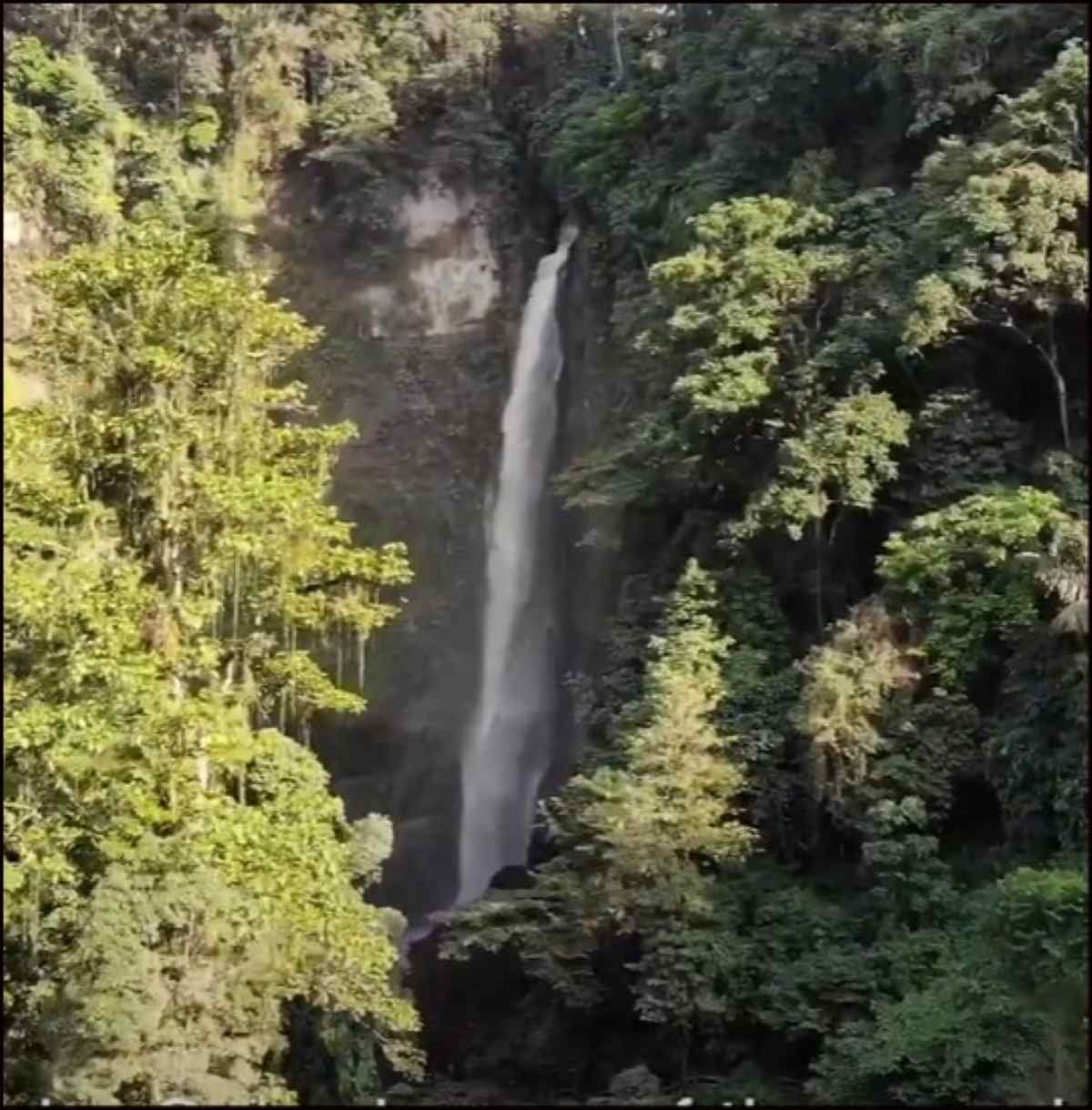
7. Limunsudan Falls: A Two-Tiered Wonder of Philippines Waterfall


Majestic Heights and Pristine Wilderness

Limunsudan Falls in Iligan City is a towering beauty, considered the second-highest waterfall in the Philippines. Its two tiers drop a total of 870 feet, making it a spectacular sight amidst the untouched wilderness of Mindanao.

How to Get There: From Iligan City, it’s about a 3-hour drive by 4×4 vehicle, followed by a 1-hour hike to reach the falls. The journey can be challenging but rewarding for adventure lovers.

Best Time to Visit: The best time to visit Limunsudan Falls is during the rainy season (June to November) when the falls are at their fullest.


Fees, Facilities, and Safety Rules

There is currently no entrance fee, as the area is still undeveloped for mass tourism. However, local guides are recommended for safety. There are no facilities, so pack your essentials—water, food, and first aid kits. Due to its remote location, the site is pristine, and visitors are expected to practice “Leave No Trace” principles.


Capture the Heights: Photography and Nearby Wonders

To capture the grandeur of Limunsudan Falls, wide-angle lenses are a must. For those looking for nearby attractions, Iligan City is known as the “City of Majestic Waterfalls,” with Maria Cristina Falls and Tinago Falls located nearby.

Cambugahay Falls
Cambugahay Falls Photo By KAYYY B @Pexels

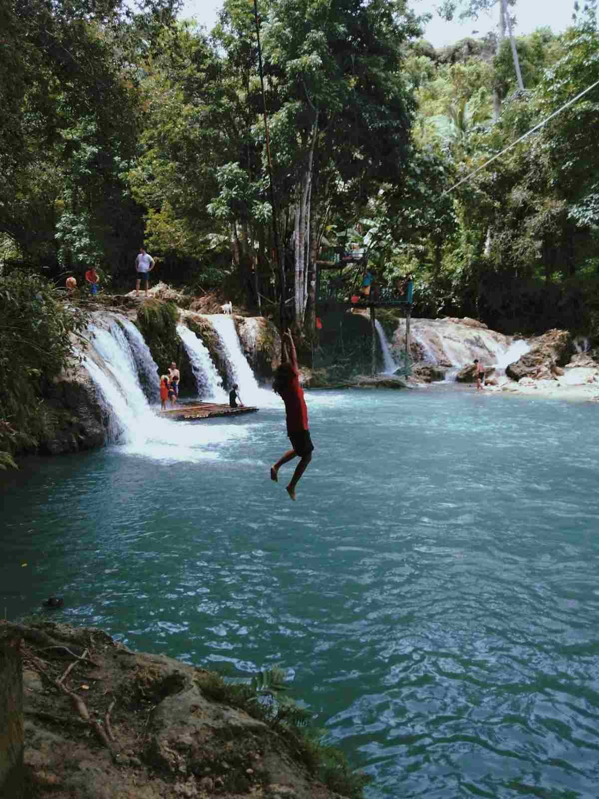
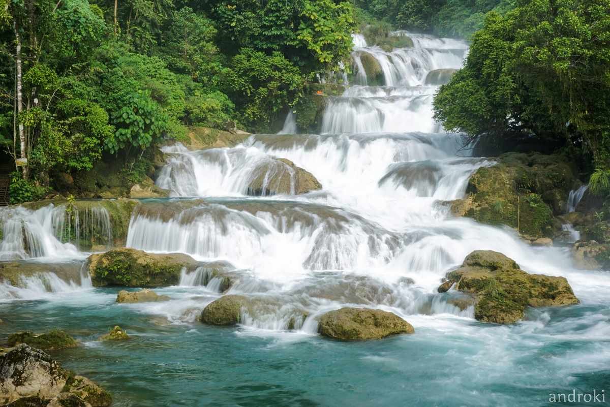
8. Cambugahay Falls: A Tropical Playground in Siquijor


Turquoise Waters and Rope Swings Await!

Cambugahay Falls in Siquijor is a three-tiered waterfall that offers both beauty and fun. The turquoise pools are perfect for swimming, and the rope swings add a touch of adventure.

How to Get There: From Siquijor’s main town, it’s a short 15-minute habal-habal (motorcycle taxi) ride to the falls, followed by a quick 5-minute walk.

Best Time to Visit: Visit from March to May when the water is clear and the weather is sunny, perfect for swimming and taking photos.


Entry Fees, Amenities, and Safety Information

There is a small entrance fee of PHP 20.00. Life jackets and rope swings are available for rent. The site has basic amenities like restrooms and picnic areas. Swimming is allowed, and the water is generally shallow. However, always check the depth before jumping from the rope swings.


Nearby Sights and Scenic Photo Spots

While in Siquijor, don’t miss Salagdoong Beach, famous for its cliff diving spots. For photos, capture Cambugahay’s pools from above for that perfect turquoise contrast against the greenery.

Inambakan Falls
Inambakan Falls

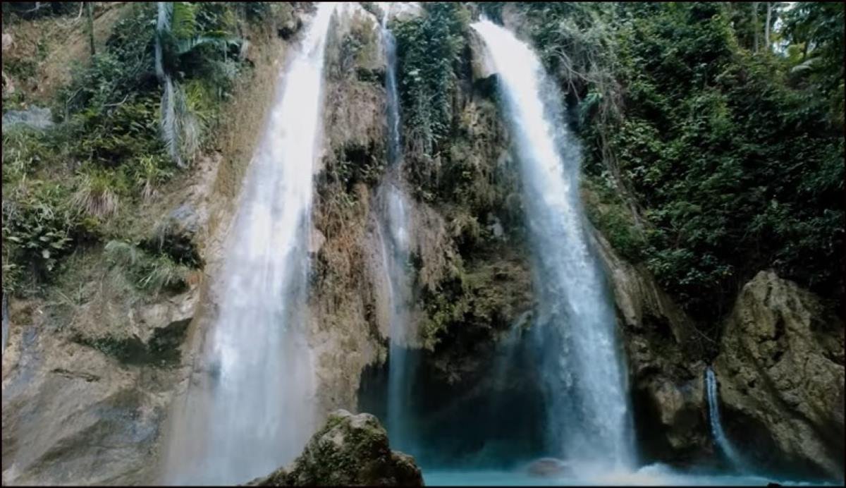
9. Inambakan Falls: A Hidden Gem in Cebu


Discover Cebu’s Best-Kept Secret!

Inambakan Falls in Ginatilan, Cebu, is an off-the-beaten-path Philippines waterfall featuring five tiers and crystal-clear pools. It’s less crowded than Kawasan Falls but equally stunning.

How to Get There: From Cebu City, it’s a 4-hour bus ride to Ginatilan, followed by a 10-minute habal-habal (motorcycle taxi) ride to the falls.

Best Time to Visit: The best time to visit is during the dry season, from December to May, to avoid slippery trails and enjoy clear water.


Fees, Facilities, and Safety Guidelines

There is an entrance fee of PHP 50.00. Basic amenities like picnic areas and restrooms are available. The water can get deep, so life jackets are recommended for non-swimmers.


Snap the Perfect Shot: Nearby Attractions and Photo Tips

Capture great shots from this Philippines waterfall from the lower pools for a cascading effect in your photos. Nearby, visit Ginatilan Church, a historic site dating back to the Spanish colonial period.

Seven Falls Lake Sebu
Panagbenga Festival2 Photo By Kim Villanueva @Pexels

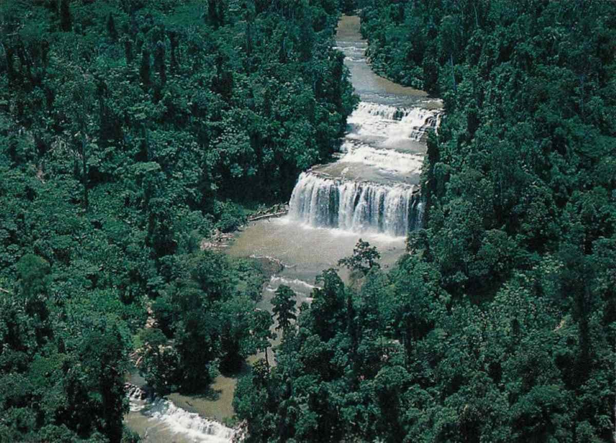
10. Seven Falls (Lake Sebu): An Adventure in South Cotabato


Seven Majestic Philippines Waterfalls in One Adventure

The Seven Falls in Lake Sebu, South Cotabato, offer not one but seven waterfalls, each with its own unique charm. The most popular is Hikong Bente, the tallest at 70 meters.

How to Get There: From General Santos City, it’s a 3-hour bus ride to Lake Sebu, followed by a short jeepney ride to the falls.

Best Time to Visit: Visit between June and November to see the falls in full force.


Fees, Amenities, and Safety Guidelines

There is an entrance fee of PHP 20.00, and a zipline ride across the falls costs around PHP 300.00. Swimming is not allowed in most areas, but the site is equipped with picnic areas and restrooms.


Photography and Nearby Attractions

The zipline offers the best view of all seven falls. While you’re in Lake Sebu, visit the T’boli Cultural Village to learn about the indigenous people and their crafts.

Tinuy-an Falls
Tinuy-an Falls Photo By MyCommons199 @Wikipedia


Essential Tips for an Epic Philippines Waterfall Adventure

Exploring a Philippines waterfall is like stepping into a natural wonderland. With pristine waters cascading over lush landscapes, each site offers a unique adventure. But before you pack your bags and head off, there are some essential tips and advice you should keep in mind to ensure your waterfall journey is safe, enjoyable, and unforgettable.


1. Know What to Expect: The Thrill and Challenge of a Waterfall Escapade

Waterfall sites in the Philippines range from easily accessible to downright challenging. Some are just a short walk from the main road, while others require hours of hiking, sometimes through dense forests or steep terrain. Before heading out, do your research on the specific Philippines waterfall you plan to visit. This way, you’ll be mentally and physically prepared for the kind of adventure that awaits you.

Some waterfalls, like Tinuy-an Falls in Surigao del Sur or Kawasan Falls in Cebu, are more tourist-friendly with facilities and guides readily available. Others, such as Limunsudan Falls in Iligan, offer a raw, rugged experience and require you to be more self-sufficient. Either way, knowing the difficulty level will help you pack the right gear and manage your expectations.


2. Gear Up for the Adventure: What to Bring on Your Philippines Waterfall Journey

When chasing waterfalls, having the right gear is crucial. Here’s a rundown of must-haves for your Philippines waterfall adventure:

– Sturdy Footwear: Whether it’s a short walk or a long trek, you’ll likely encounter slippery rocks, mud, or uneven ground. Waterproof hiking shoes with good grip are a lifesaver.

– Waterproof Bags: With all that water splashing around, you’ll want to keep your valuables safe and dry. Invest in a good waterproof bag or at least dry sacks for your electronics.

– Lightweight Clothes: Wear breathable, quick-drying clothes. You’re going to get wet, and you want to dry off quickly for comfort. A swimsuit under your outfit is always a good idea.

– Towel and Extra Clothes: After a refreshing dip, you’ll want to change into something dry. Microfiber towels are lightweight and easy to pack.

– Water and Snacks: Waterfalls are often located far from convenience stores. Stay hydrated and energized by bringing plenty of water and light snacks.

– Sunscreen and Bug Repellent: Most Philippines waterfalls are surrounded by dense vegetation, so bug bites are common. Protect your skin from both the sun and insects.

– First-Aid Kit: A basic first-aid kit with band-aids, antiseptic wipes, and pain relievers will come in handy in case of minor injuries like cuts or scrapes.

– Eco-Friendly Essentials: Consider packing eco-friendly toiletries and reusable water bottles to reduce your impact on the environment. Many waterfalls promote sustainable tourism, so let’s do our part to protect these natural treasures.


3. Safety First: Precautions to Take on Your Waterfall Adventure

Waterfalls are beautiful but can be dangerous if proper precautions aren’t taken. To ensure your safety, follow these essential tips:

– Respect Local Guidelines: Some waterfalls may have restricted areas due to the strength of the current or the depth of the pools. Always follow posted signs and listen to local guides.

– Check Weather Conditions: Heavy rain can turn a gentle waterfall into a raging torrent. It’s always best to avoid visiting waterfalls during or immediately after heavy rain to prevent accidents like flash floods.

– Wear Life Jackets: Even if you’re a strong swimmer, it’s a good idea to wear a life jacket, especially in deep or fast-moving pools. Some sites, like Aliwagwag Falls in Davao Oriental, rent out life jackets for visitors.

– Be Mindful of the Terrain: Wet rocks and steep trails are common near waterfalls. Move slowly and watch your step. Use walking sticks for balance on tricky trails.

– Don’t Swim Alone: If you plan to swim, make sure you’re with a buddy. Even the calmest pool can have hidden currents.

– Know Your Limits: Not all waterfall hikes are for everyone. If a trail feels too difficult or unsafe, it’s okay to turn back and try another site. There are plenty of waterfalls to explore in the Philippines!


4. The Best Time to Visit a Philippines Waterfall

While Philippines waterfalls are stunning year-round, the best time to visit is during the dry season, typically from November to May. During these months, the water is clearer, and trails are less slippery. However, if you prefer to see the waterfalls at their most powerful, visiting during the rainy season (June to October) is an option, though you’ll need to be more cautious due to the risk of flash floods.

Some waterfalls, like Cambugahay Falls in Siquijor, offer a tropical paradise year-round with turquoise waters that invite you in for a swim. Others, like Kaparkan Falls in Abra, are seasonal and only accessible during the rainy months, transforming into magnificent terraced cascades that are a sight to behold.


5. Responsible Tourism: Leave No Trace

When visiting a Philippines waterfall, it’s important to respect the environment and local communities. The rule is simple: Leave No Trace. Always take your trash with you and avoid disturbing wildlife. Many waterfalls are located in protected areas, and local communities rely on tourism for their livelihood. Supporting eco-friendly practices helps ensure that these beautiful sites remain pristine for future generations.

– Stick to Designated Trails: Avoid creating new paths that could lead to erosion or disturb local flora and fauna.

– Pack Out What You Pack In: Always bring a trash bag with you, and never leave litter behind.

– Support Local Guides and Vendors: Hiring a local guide not only enhances your experience but also supports the community. Additionally, purchasing snacks or souvenirs from local vendors helps boost the local economy.


6. Capture the Moment: Photography Tips for Philippines Waterfalls

A Philippines waterfall is a photographer’s dream! To make the most out of your shots, here are a few tips:

– Golden Hour Magic: The best time for photography is during the early morning or late afternoon when the sunlight creates softer shadows and enhances the colors of the water and surroundings.

– Long Exposure Shots: For that silky-smooth waterfall effect, use a tripod and set your camera to a slow shutter speed.

– Wide Angles: Capture the full grandeur of the waterfall by using a wide-angle lens, especially when the waterfall is as massive as Tinuy-an Falls or Limunsudan Falls.

Make sure to enjoy the experience and not just live through your camera. Sometimes, the best memories are the ones you create without a lens in between!


7. Final Thoughts: What to Keep in Mind Before Your Philippines Waterfall Adventure

A Philippines waterfall adventure is more than just a scenic experience; it’s a chance to connect with nature, explore diverse landscapes, and immerse yourself in the culture of the region. Before you embark on your journey, make sure you’re prepared with the right gear, safety precautions, and knowledge about the site you’re visiting.

Remember to stay hydrated, take care of your belongings, and always respect local customs. With the right mindset and preparation, your Philippines waterfall journey will be one for the books—a memorable adventure you’ll cherish forever!

So, ready to chase waterfalls in the Philippines? Let the adventure begin!

Sinulog Filipino Festival

Top 6 Filipino Festivals To Visit: A Colorful Celebration of Culture and Tradition

Top 6 Filipino Festivals To Visit: A Colorful Celebration of Culture and Tradition

When it comes to grand celebrations, the Philippines is a treasure trove of vibrant festivals and tourist attractions. Known as fiestas, these events are deeply ingrained in Filipino culture, celebrated with colorful costumes, lively music, and captivating rituals. Whether rooted in religion, harvest, or indigenous traditions, every Filipino festival offers a unique window into the heart of its people. For tourists, these festivals are an immersive way to experience the country’s history, traditions, and the infectious joy that Filipinos are known for.

Now, let me take you on a deep dive into some of the Philippines’ most iconic festivals: Sinulog, Ati-Atihan, Pahiyas, Dinagyang, Panagbenga, and Kadayawan. You’ll find everything from must-see events, tips on accessibility, and logistics, to the unique local dishes and souvenirs to expect. Trust me, after reading this, you’ll want to pack your bags and jump into the nearest fiesta!

Sinulog Festival Viva Sto. Nino
Sinulog Festival By Herbert Kikoy @Wikipedia

(1) The Sinulog Festival: Cebu’s Devotion and Dance Spectacle

      When:  Every 3rd Sunday of January

      Where:  Cebu City, Philippines

      Attendees:  2-3 million people

      Highlights:  Grand parade, street dancing, and vibrant costumes celebrating the Sto. Niño (Child Jesus). Sinulog is one of the most famous and well-attended festivals in the Philippines, known for its colorful displays and cultural performances.


Cultural Significance and Origins: Honoring the Santo Niño

The Sinulog Festival in Cebu City is held every third Sunday of January and is one of the grandest religious Filipino festivals. It honors the Santo Niño (Child Jesus), an important symbol of Christianity in the country. Sinulog traces its origins to pre-Hispanic times, where locals worshipped wooden idols. This Filipino festival’s transformation into a Christian event began in 1521, when Portuguese explorer Ferdinand Magellan gifted a statue of the Santo Niño to Queen Juana of Cebu. The statue became a vital part of Cebuano faith, and over the centuries, Sinulog grew into a celebration of religion, blending indigenous and Catholic traditions.

Sinulog means “like water current,” referring to the traditional two-steps-forward, one-step-back dance that mimics the flow of the Cebu River. This rhythmic movement is central to the festival, symbolizing the Filipinos’ cultural and religious journey.


A Parade You Won’t Forget! Must-See Events

Sinulog’s highlights are its spectacular street parades and dance competitions, attracting over a million spectators each year.

Grand Parade: Imagine an endless procession of brightly costumed dancers moving to the beat of drums and gongs. The streets explode with color and energy, making this parade a true feast for the senses.

Sinulog Dance Competition: Local performers show off the traditional Sinulog dance in a fierce competition. The choreography is not only technically impressive but also steeped in symbolism.

Fluvial Procession: Witness a river parade where a replica of the Santo Niño is carried in a decorated boat, accompanied by smaller boats and fervent prayers. It’s an event that blends the sacred and the spectacular.

Sinulog Novena Mass
SINULOG NOVENA MASS By Jumelito Capilot @Wikipedia

Where and How to Experience Sinulog Like a Pro: Best Viewing Spots, Weather, and Accessibility

If you’re keen on seeing the parade, get your spot early along Osmeña Boulevard, the heart of this Filipino festival. For a more comfortable view, consider booking tickets for the grandstand seating, offering you a front-row seat to all the action. Cebu is quite hot in January, with temperatures reaching up to 30°C (86°F), so come prepared with light clothes, sunscreen, and water.

Cebu City is accessible by plane via Mactan-Cebu International Airport and has plenty of accommodation options—from budget hostels to five-star hotels—but make sure to book months in advance. Traffic and crowds can be overwhelming, so it’s best to stay near the city center to avoid the rush.


What’s Cooking in Cebu: Local Food, Dining, and Drinks

During Sinulog, Cebu becomes a culinary wonderland! Make sure to try lechon, a roasted pig delicacy the city is famous for. Street vendors pop up everywhere, offering affordable local favorites like puso (hanging rice), siomai, and bbq skewers. Don’t miss Cebu’s danggit (dried fish) for a salty, crunchy snack.

For drinks, buko juice (coconut water) is a refreshing option to beat the heat. You’ll also find stalls selling all kinds of local refreshments, from fruit shakes to Sago’t Gulaman (sweetened tapioca with jelly).


What to Buy and Where to Stay: Souvenirs and Accommodations

Sinulog souvenirs range from intricate Santo Niño figurines to colorful festival shirts and handcrafted accessories. You’ll find these at Carbon Market or stalls set up near the festival routes. Budget-wise, expect to spend around ₱8,000 to ₱15,000 ($150-$270) for accommodations, food, and souvenirs. For accommodations, aim to book at least 6 months in advance, especially if you plan to stay in the city center.

Ati-Atihan Festival
Ati-Atihan Festival Photo By Elisolidum @Wikipedia

(2) Ati-Atihan Festival: Kalibo’s Tribal Extravaganza

      When:  Every 3rd Sunday of January

      Where:  Kalibo, Aklan Philippines

      Attendees:  1-2 million people

      Highlights:  Known as the “Mother of all Philippine Festivals,” Ati-Atihan honors the Sto. Niño with indigenous-inspired costumes, body paint, and street dances. The whole town turns into a vibrant party.


Cultural Origins and the Spirit of Ati-Atihan: A Filipino Festival Like No Other

Ati-Atihan, dubbed as “The Mother of All Filipino Festivals,” is held in Kalibo, Aklan, every third week of January. The festival celebrates both Santo Niño and the Ati people, the indigenous group that originally inhabited Panay Island. According to legend, when Malay settlers arrived, the Atis generously welcomed them, and to honor this bond, locals dress in blackface, mimicking the Atis’ dark skin, and perform tribal dances in the streets.

Unlike other Filipino festivals, Ati-Atihan is participatory. Here, it’s not just about watching the performances—you’re encouraged to join in! The phrase “Hala Bira! Pwera Pasma!” echoes throughout the town, encouraging revelers to dance and celebrate despite exhaustion.


You Won’t Want to Miss This: Event Highlights of Ati-Atihan

Street Dancing: Revelers parade through the streets in indigenous-inspired costumes, carrying images of the Santo Niño. This isn’t just any parade—you’re invited to join in and become part of the celebration.

Santo Niño Procession: On the final day, an image of the Holy Child is carried through the streets, with participants offering prayers and thanks.

Religious and Cultural Shows: Performances combine tribal rituals with Catholic traditions, reflecting the unique blend of Filipino spirituality.

Ati-Atihan Queen
Ati-Atihan Queen Photo By Allan Jay Quesada @Wikipedia

The Best Festival Spots and Tips for Attending

The main action happens around Kalibo’s town plaza, where performances and religious rites take place. If you want a good spot for the procession, arrive early to secure a spot near Pastrana Park. Kalibo’s weather in January is warm, around 26-32°C (79-89°F), so pack light clothing, comfortable shoes, and don’t forget your water bottle. Kalibo can be reached via Kalibo International Airport or through nearby Caticlan if you’re coming from Boracay. Accommodations are more limited than in larger cities, so booking early is key.


What to Expect from Local Cuisine and Souvenirs you can take.

Local street vendors line the streets during Ati-Atihan, offering everything from grilled chicken inasal to pork barbecue. Aklan is also known for binakol, a chicken soup cooked with coconut water, and batchoy, a noodle soup loaded with pork, liver, and chicharron. Kalibo is famous for its handmade baskets and woven products, which make great souvenirs. You can also buy Ati-Atihan memorabilia, like tribal masks and Santo Niño statuettes. Budget about ₱6,000 to ₱10,000 ($110-$180) for your trip, depending on your accommodation choice.

Pahiyas Festival
Pahiyas Festival Photo By Patrickroque01 @Wikipedia

(3) Pahiyas Festival: Lucban’s Harvest Festival of Colors

      When:  Every May 15

      Where:  Lucban, Quezon Philippines

      Attendees:  1 million+ people

      Highlights:  Houses are decorated with colorful “kiping” (rice wafers) and agricultural products to give thanks for a bountiful harvest. The festival is a grand showcase of creativity and traditional Filipino hospitality.


The Heart of Pahiyas: A Thanksgiving Like No Other

Held every May 15 in Lucban, Quezon, Pahiyas Festival is a colorful harvest Filipino festival dedicated to San Isidro Labrador, the patron saint of farmers. It’s a thanksgiving for a bountiful harvest, with each household adorning their homes with kiping, brightly colored rice wafers, fruits, and vegetables, turning the entire town into a massive art gallery.


Eye-Catching Displays You’ll Never Forget

Decorated Houses: The town’s biggest draw is the intricately decorated houses. Walking through Lucban feels like stepping into a world made of vibrant fruits and vegetables.

Agricultural Parade: See floats made entirely of produce, accompanied by carabaos (water buffalo) decked out in traditional gear.

Cooking Competitions: Enjoy cooking contests featuring Lucban’s signature dishes, like longganisa and pancit habhab.


Where to Go for the Best Views and Travel Tips

This Filipino festival’s highlight is the house decoration competition, and the best way to experience it is to walk through the streets of Lucban. The parade route usually starts near the town center, but you’ll want to arrive early to beat the crowds. May in Lucban can get quite hot, with temperatures ranging from 27-35°C (80-95°F), so be sure to bring an umbrella for shade and stay hydrated. Lucban is accessible via a 3-4 hour bus ride from Manila. Accommodations in town are limited, but nearby areas like Tayabas or Lucena offer more options. Book at least 3 months in advance to ensure availability during the festival period.

Pahiyas Filipino Festival
Pahiyas Festival By Weirdobelle @Wikipedia

A Gastronomic Journey in Lucban: Local Cuisine you can enjoy

The Pahiyas Festival is a culinary celebration as much as a visual one. As you stroll through the streets, you’ll find food stalls offering pancit habhab, a local noodle dish served on banana leaves, and Lucban longganisa, a garlicky sausage that the town is famous for. Other Filipino festival staples include kiping, the colorful rice wafers that decorate homes and can be eaten fried or grilled. You’ll also want to try hardinera, a type of meatloaf unique to Lucban. Drinks range from fresh coconut juice to locally brewed lambanog, a potent Filipino coconut liquor.


What to Bring Home and What to Spend

A visit to Lucban wouldn’t be complete without buying handmade Lucban hats, woven baskets, and longganisa to take home. This Filipino festival also features many stalls selling kiping art and other colorful handicrafts. Budget around ₱5,000 to ₱8,000 ($90-$145) for food, transportation, and accommodation, though costs may go higher depending on your preference for dining and lodging. Lucban is a small town, so consider staying nearby in larger towns like Lucena for more accommodation options.

Dinagyang Filipino Festival
Dinagyang Festival Photo By EMMAN A. FORONDA @Wikipedia

(4) Dinagyang Festival: Iloilo’s Dance and Devotion to the Santo Niño

      When:  Every 4th Sunday of January

      Where:  Iloilo City, Philippines

      Attendees:  1 million+ people

      Highlights:  Dinagyang features warrior-like dancers in elaborate costumes performing in honor of the Sto. Niño. It is famous for its choreographed street dancing competitions and vibrant cultural displays.


The Historical and Cultural Significance of Dinagyang

Dinagyang Festival, celebrated every fourth weekend of January in Iloilo City, is both a religious and cultural Filipino festival honoring the Santo Niño and commemorating the arrival of Malay settlers in Panay. Like the Ati-Atihan Festival, Dinagyang features street dancing with participants painted in black, representing the Ati tribe, and wearing vibrant, intricate costumes.

Dinagyang, which means merrymaking, is a celebration not just of Iloilo’s faith but also its vibrant history and strong community spirit. This Filipino festival is a blend of religious devotion, competitive performance art, and a showcase of Iloilo’s rich cultural heritage.


Highlights You Must Not Miss: Dance, Color, and Excitement!

Kasadyahan Cultural Parade: This is a highlight that features traditional performances from local tribes, showcasing Iloilo’s rich cultural tapestry.

Santo Niño Fluvial Procession: A religious highlight where devotees carry the image of Santo Niño down the Iloilo River, creating a unique blend of piety and spectacle.

Ati Tribe Dance Competition: The most awaited event where competing groups showcase intricate choreography, vibrant costumes, and powerful drumbeats in a fierce, stunning competition.

Dinagyang Festival
Dinagyang Festival Photo By Ranieljosecastaneda @Wikipedia

How to Get the Best Filipino Festival Experience

The performances and parade happen along the main streets of Iloilo City, especially around Freedom Grandstand. For a good view, it’s recommended to purchase tickets to the grandstand seating, which offers a better perspective of the performances and a more comfortable experience. The weather in Iloilo during January can be unpredictable—expect hot days around 30°C (86°F) but be prepared for occasional rain showers. Bring a hat, sunscreen, and an umbrella.

Iloilo is easily accessible by plane through Iloilo International Airport. It’s well-connected to major cities like Manila and Cebu. Accommodations in Iloilo range from budget inns to luxury hotels, but book well in advance, as the festival brings in thousands of visitors.


Iloilo’s Culinary Gems: Food, Drinks, and Dining Spots

Iloilo is famous for its rich and flavorful cuisine. During Dinagyang, street vendors serve local delicacies like batchoy, a hot noodle soup with pork innards and crunchy chicharrón, and pinasugbo, deep-fried banana slices coated in caramel. Another must-try is biscocho, a crunchy, buttery bread perfect for snacking. For drinks, refresh yourself with calamansi juice or try the local San Miguel beer while enjoying this Filipino festival buzz.


What You’ll Spend and What You’ll Buy

Look for handcrafted Ati masks, colorful Dinagyang-themed shirts, and Santo Niño statues as souvenirs. You can also bring home weaving products from Iloilo, such as blankets, mats, and baskets made by local artisans. Budget at least ₱8,000 to ₱12,000 ($150-$220) for accommodation, food, and souvenirs during Dinagyang.

Panagbenga Filipino Festival
Panagbenga Festival Photo By Kim Villanueva @Pexels

(5) Panagbenga Festival: Baguio’s Blooming Marvel

      When:  Every February (Whole Month)

      Where:  Baguio City, Philippines

      Attendees:  1 million+ people

      Highlights:  Also known as the Baguio Flower Festival, Panagbenga is celebrated with parades featuring floats adorned with flowers, street dancing, and exhibitions. The cool climate of Baguio makes this festival a major draw for tourists.


Why Panagbenga Stands Out: A Filipino Festival of Flowers and Culture

Panagbenga Festival, held every February in Baguio City, is a month-long celebration dedicated to the city’s thriving flower industry. The word Panagbenga means “season of blooming” in the local Kankanaey dialect. What makes this Filipino festival unique is its focus on flowers—its floats, costumes, and events are all inspired by the blooms that thrive in the cool climate of the country’s summer capital. The festival started in 1996 as a way to boost the city’s tourism and pay homage to its vibrant flower-growing industry.


Event Highlights: A Parade of Blooms You Can’t Miss

Grand Float Parade: The highlight of this Filipino festival where intricately designed floats made entirely of fresh flowers cruise through the streets of Baguio, accompanied by performers in floral costumes.

Street Dance Parade: Performers, including school children, dance along Baguio’s main streets in flower-inspired attire, bringing vibrant colors and energy to the chilly city.

Market Encounter: A month-long market where you can buy plants, flowers, and various handicrafts from local vendors, perfect for a souvenir hunt.

Panagbenga Festival
Panagbenga Festival2 Photo By Kim Villanueva @Pexels

Tips for a Perfect Panagbenga Experience

The Session Road area in Baguio City offers some of the best spots to watch the grand parade, but it can get crowded fast. Arrive early or book a spot in hotels overlooking the parade route. February is Baguio’s peak season, with cool weather averaging around 15-20°C (59-68°F), so pack warm clothing. Baguio can be reached via a 4-6 hour bus ride from Manila. Accommodations range from quaint inns to high-end hotels, but since Panagbenga is a major tourist draw, it’s important to secure your lodging well ahead of time.


Where to Eat in Baguio: Local Food and Dining Delights

Baguio is famous for its strawberries, so don’t miss the chance to indulge in strawberry taho (a local tofu snack topped with strawberry syrup), strawberry shortcake, or strawberry ice cream. Another must-try is sundot kulangot, a sweet delicacy made of sticky rice and coconut jam sold in tiny wooden shells. Baguio’s cool weather makes it the perfect place to enjoy warm meals like Bulalo, a beef soup with bone marrow, or Pinikpikan, a traditional Cordilleran chicken dish.


What to Expect in Panagbenga: Souvenirs and Budget

Local artisans sell woven fabrics, wood carvings, and handmade jewelry, making Baguio a great place to find unique, handcrafted souvenirs. Don’t leave without buying a jar of Baguio’s famous peanut brittle or a pack of Sagada coffee. Expect to spend around ₱6,000 to ₱10,000 ($110-$180) for accommodation, food, and festival-related expenses, depending on your choice of lodging and activities.

Kadayawan Festival
Kadayawan Festival Photo By Fpj455

(6) Kadayawan Festival: Davao’s Celebration of Life and Abundance

      When:  Every 3rd Week of August

      Where:   Davao City, Philippines

      Attendees:  800,000 – 1 million people

      Highlights:  Kadayawan is a thanksgiving festival celebrating Davao’s bountiful harvest, culture, and diverse indigenous communities. Visitors enjoy a mix of street dancing, floral floats, and local crafts.


The Cultural Origins of Kadayawan: A Filipino Festival Rooted in Tradition

Every August, Davao City comes alive with the Kadayawan Festival, a celebration of bounty and life. This Filipino festival honors the city’s 11 indigenous tribes, celebrating their cultural heritage, the harvest of fruits, and the natural beauty of Davao. The name “Kadayawan” comes from the word “madayaw,” which means good or valuable, reflecting the festival’s focus on the city’s abundance.

Kadayawan was originally a celebration by the indigenous people to give thanks for the bountiful harvest. Over time, it evolved into a grand festival showcasing Davao’s agricultural products, culture, and the harmonious coexistence of its many ethnic groups.


The Top Kadayawan Experiences: Events You Shouldn’t Miss

Indak-Indak sa Kadalanan: This street dancing competition showcases the unique traditions of Davao’s various tribes. Performers wear colorful costumes and dance to indigenous music, bringing the city streets to life.

– Pamulak sa Kadayawan: A grand parade featuring floats decorated with fresh flowers and fruits, highlighting Davao’s rich agricultural industry.

– Hiyas ng Kadayawan: A beauty pageant that honors Davao’s indigenous tribes, with contestants showcasing traditional attire and talents in a celebration of indigenous beauty.

Kadayawan Filipino Festival
Kadayawan Festival Photo By Brendo Boyose @Pexels

How to Prepare for the Festival and Best Spots!

This Filipino festival’s events take place in key locations like San Pedro Street and the Davao City Hall, where you’ll find the best vantage points for the parades and performances. August in Davao is rainy, so bring a raincoat and umbrella, but don’t let that dampen your festival spirits! Davao’s cool, tropical weather during this Filipino festival season averages around 28°C (82°F).

Davao is accessible via Francisco Bangoy International Airport, with regular flights from Manila and Cebu. For accommodation, Davao offers a wide range of options from budget hostels to luxurious hotels, but it’s always best to book ahead.

Flavors of Davao: Must-Try Local Dishes During Kadayawan

Davao is famous for its durian, the infamous fruit with a strong smell and creamy texture that locals swear by. Try durian candy, durian ice cream, or even durian coffee if you’re feeling adventurous. For heartier meals, dig into grilled tuna panga (jaw), kinilaw (raw fish marinated in vinegar), or sinuglaw, a fusion of grilled pork and kinilaw.

Festival Budget and Souvenir Shopping: How Much You’ll Need

Davao is known for its affordable crafts, such as woven bags, beadwork, and hand-carved figurines from local artisans. Be sure to bring home some Malagos chocolate or civet coffee, both of which are proudly made in Davao. For budget-conscious travelers, set aside ₱7,000 to ₱10,000 ($130-$180) for accommodations, food, and other festival-related expenses.


Preparing for Your Filipino Festival Adventure

Before attending any Filipino festival, here are a few tips to make your trip smoother:

  1. Book Early: Accommodations fill up fast during festival season. Make reservations 2-3 months ahead if possible.
  2. Pack Light but Smart: Bring light clothes, sunscreen, and water, especially for hot festivals like Pahiyas or Ati-Atihan. Don’t forget an umbrella for rainy season festivals like Kadayawan.
  3. Stay Hydrated and Eat Wisely: The heat and excitement can be draining, so drink lots of water and take advantage of local food stalls.
  4. Secure Your Belongings: With big crowds come opportunists, so keep your valuables close in a secure bag.
  5. Plan for Extra Time: If possible, arrive at least a day before the festival to get familiar with the area and secure the best spots for viewing.


Conclusion: Embrace the Festive Spirit

Filipino festivals are truly something you need to experience at least once in your lifetime. Each Filipino festival offers a unique cultural immersion, allowing you to understand the deep connection between the people, their faith, and the land. These Filipino festivals are not just events—they’re immersive experiences that allow you to feel the vibrant spirit of the Philippines. Whether you’re dancing in the streets of Iloilo, feasting in Lucban, or marveling at flower-covered floats in Baguio, these celebrations offer a glimpse into the rich culture and traditions that make the Philippines one of Asia’s most colorful destinations.

So what are you waiting for? Plan your trip and dive into the vibrant world of Filipino festivals—trust me, it’ll be an unforgettable adventure!

Marine Biodiversity

Breathtaking World of Biodiversity: Top 6 UNESCO Eco-Tourism Gold in the Philippines!

Breathtaking World of Biodiversity: Top 6 UNESCO Eco-Tourism Gold in the Philippines!

When we speak of biodiversity, we are referring to the variety of life found in a particular habitat or ecosystem. It encompasses all living organisms—plants, animals, fungi, and even microorganisms—interacting with each other in balanced, interconnected systems. The Philippines, known for its vast natural treasures, is blessed with numerous ecosystems that are home to a wide variety of species, many of which are found nowhere else in the world. This exceptional natural wealth has earned the Philippines several UNESCO Biosphere Reserves, which are areas designated to promote conservation, sustainable development, and the preservation of cultural diversity.

These reserves are unique landscapes where human activities coexist harmoniously with nature, fostering a mutually beneficial relationship between people and the environment. A UNESCO Biosphere Reserve is an area recognized under UNESCO’s Man and the Biosphere Programme. These reserves are models for balancing the conservation of biodiversity with sustainable economic development, involving the local communities who call these regions home.

To earn this status, a site must demonstrate exceptional biodiversity, have an effective management system in place, involve local people in conservation and sustainable development efforts, and serve as a hub for scientific research and environmental education. Now, let’s explore the stunning biosphere reserves of the Philippines in greater detail and understand what makes them so special.

Verde Island Biodiversity
Verde Island, Batangas Photo By Dastreetfilmer from Wikipedia

1. Verde Island Passage: The Center of Marine Biodiversity


A Marine Haven: Biodiversity and Cultural History

The Verde Island Passage (VIP) is known globally as the “Center of Marine Biodiversity” due to the staggering variety of marine species found in its waters. Located between the islands of Luzon and Mindoro, this marine corridor hosts over 1,700 species of fish and more than 300 species of coral. It’s one of the most biodiverse marine areas on the planet. Among its inhabitants are gentle giants like whale sharks, numerous species of rays, and vibrant schools of reef fish. 

Diving here is like stepping into a living, breathing underwater kaleidoscope of life, where even the most experienced divers are left in awe of its beauty. Researchers regularly flock to the Verde Island Passage to study its intricate ecosystems, which are still revealing new species to science.

But biodiversity in the Verde Island Passage extends beyond marine life. Its surrounding coastal communities have a deep-rooted cultural connection to the sea. Fishing is the main livelihood, passed down through generations, and plays a central role in local traditions and day-to-day life. The people here have long respected the bounty of the sea, relying on sustainable practices to ensure that both marine life and their way of life continue to thrive.


Conservation Efforts and Challenges: Balancing Livelihood and Preservation

Despite its rich biodiversity, the Verde Island Passage faces many threats, primarily due to human activities. Overfishing, plastic pollution, and the pressures of industrialization—particularly from shipping lanes and nearby ports—pose significant challenges to conservation. To mitigate these risks, several marine protected areas (MPAs) have been established within the Verde Island Passage. 

These MPAs help limit human activities in certain areas to allow marine ecosystems to recover and thrive. Fishermen are encouraged to participate in community-based conservation efforts, often trained as reef rangers who help monitor and protect local reefs.

However, the challenge of balancing conservation with the needs of local communities remains. Fishing is a critical source of income for many families, and while sustainable fishing practices are encouraged, ensuring everyone adheres to these regulations is not always easy. Ongoing education and community involvement are essential in overcoming these challenges. Fortunately, partnerships between NGOs, local governments, and international conservation groups have shown positive results, slowly but surely moving towards a more sustainable future for the region.

Marine Biodiversity
Marine Biodiversity Photo By Francesco Ungaro @Pexels

Exploring Verde Island Passage: Dive into Eco-Tourism and Scenic Adventures

For tourists, the Verde Island Passage offers some of the best diving spots in the world. Anilao, located in Batangas, serves as a gateway to this underwater paradise and is known for its crystal-clear waters, vibrant coral reefs, and abundance of marine life. Whether you’re a seasoned diver or a curious beginner, Anilao offers an unparalleled diving experience where you can swim with sea turtles, rays, and schools of tropical fish. Non-divers can explore the beauty of the region through island-hopping tours that offer scenic views of lush coastal landscapes, hidden beaches, and picturesque fishing villages.

Food lovers will be delighted with Batangas’ local cuisine. Be sure to try lomi, a hearty noodle soup known for its rich, thick broth and generous serving of meat and vegetables. The region’s thriving fishing industry also means fresh seafood is always on the menu. As for souvenirs, look for handwoven baskets and home décor items made from coconut husks, showcasing the ingenuity of the local artisans.


Accessibility and Visitor Guidelines: When and How to Visit

Verde Island Passage is relatively easy to access, with Batangas City serving as the main entry point. From Manila, Batangas is just a few hours away by car or bus. Once in Batangas City, visitors can arrange boat trips to the islands or dive centers. The best time to visit the area is during the dry season, which runs from November to May. During this time, the waters are calm, making it perfect for diving, snorkeling, and island-hopping. Visitors are reminded to respect the marine ecosystem, avoid touching corals, and follow all local guidelines to ensure that the beauty and biodiversity of the Verde Island Passage remain intact for future generations.

Coron Palawan
Coron, Palawan Photo by Leon Macapagal @Pexels

2. Palawan Biosphere Reserve: Nature’s Last Frontier


A Biodiversity Haven: Palawan’s Rich Ecosystem and Cultural Heritage

Palawan is often referred to as the “Last Frontier” of the Philippines due to its untouched natural beauty and incredibly rich biodiversity. This archipelagic province is a treasure trove of unique ecosystems—from its sprawling rainforests to its stunning coastlines and mangrove forests. The Palawan Biosphere Reserve hosts countless endemic species, including the Palawan bearcat, the Philippine pangolin, and the vibrant Palawan peacock-pheasant. Its rivers and coastal areas teem with life, including saltwater crocodiles and the endangered dugong. 

The surrounding seas are equally diverse, with coral reefs teeming with colorful marine life, from tiny clownfish to majestic reef sharks.The cultural diversity of Palawan is equally impressive. Indigenous groups like the Tagbanua and Batak people have lived in harmony with nature for centuries, relying on the land and sea for their livelihoods. 

These indigenous groups have deep-rooted traditions of sustainable farming, fishing, and foraging, using only what they need and ensuring that natural resources are preserved for future generations. Their rich cultural heritage is a testament to the connection between people and nature that the Palawan Biosphere Reserve seeks to maintain.


Conservation Efforts and Ongoing Challenges: Safeguarding Palawan’s Future

As one of the Philippines’ most ecologically important regions, Palawan has become the focus of numerous conservation efforts. The Palawan Council for Sustainable Development (PCSD) plays a key role in managing the island’s resources, ensuring that its ecosystems are protected while allowing sustainable development. One of the most well-known conservation programs in Palawan is the protection of the Tubbataha Reefs Natural Park, a UNESCO World Heritage Site. 

This massive marine protected area is crucial for the preservation of coral reefs and marine biodiversity, serving as a refuge for endangered species and a source of food and income for local communities. However, Palawan faces several challenges, including illegal logging, mining, and unsustainable tourism practices. While tourism is vital to the local economy, its rapid growth has strained the region’s natural resources. Hotels, resorts, and infrastructure developments often lead to deforestation and pollution. 

To combat these issues, there is a growing movement towards responsible eco-tourism, encouraging visitors to experience Palawan’s beauty without leaving a negative impact. Programs such as the “Pawikan Watch” involve locals and tourists in protecting sea turtles, contributing to both wildlife conservation and public awareness.

Palawan Philippines
Palawan Photo By Jenevy Vergara @Unsplash

Palawan’s Eco-Tourism and Scenic Gems: Adventures Await

For nature lovers and adventurers, Palawan offers a wide array of eco-tourism activities. The Puerto Princesa Subterranean River is one of the most popular attractions. This UNESCO World Heritage Site features a navigable underground river that flows through limestone caves adorned with stunning rock formations. Kayaking through the tranquil waters of El Nido, with its limestone cliffs and crystal-clear lagoons, is another must-do activity. 

For those seeking more remote experiences, the Calamian Islands offer secluded beaches, abundant marine life, and the unique chance to explore shipwrecks from World War II.Palawan’s cuisine is equally memorable, offering a variety of unique dishes that reflect the island’s cultural and natural richness. The daring can try tamilok, a local delicacy made from woodworms, while those looking for something more familiar can enjoy kinilaw, a Filipino version of ceviche made from fresh seafood marinated in vinegar and citrus. 

Visitors should also take the opportunity to buy traditional crafts made by the island’s indigenous groups. Hand-carved wooden items and woven baskets are popular souvenirs, often made from sustainably sourced local materials.


Getting There and the Best Time to Explore Palawan

Palawan is well connected to the rest of the Philippines, with daily flights available to Puerto Princesa and El Nido from major cities like Manila and Cebu. Once in Palawan, visitors can easily arrange tours and transport to different parts of the province. The best time to visit Palawan is from November to June, when the weather is dry and ideal for outdoor adventures. However, visitors are reminded to adhere to local environmental guidelines, such as minimizing plastic use, respecting wildlife, and staying on designated trails, to help preserve Palawan’s natural beauty for future generations.

Mt. Mayon, Albay Philippines
Legazpi City, Albay Photo By Chriz Luminario @Pexels

3. Albay Biosphere Reserve: Home of the Majestic Mayon Volcano


Thriving Biodiversity and Cultural Wealth Beneath the Volcano

Located in the Bicol region of Luzon, the Albay Biosphere Reserve is home to one of the Philippines’ most iconic landmarks—the Mayon Volcano. This active stratovolcano, with its perfectly symmetrical cone, dominates the landscape, but the surrounding ecosystems are equally impressive. The region is rich in biodiversity, featuring lush rainforests, mangroves, and coastal areas that serve as habitats for numerous species. The forests of Albay are home to animals such as the Philippine deer, the Philippine eagle, and a variety of endemic bird species. 

Meanwhile, the coastal areas are teeming with marine life, including mangrove crabs and fish that support the livelihoods of local communities. Culturally, Albay is a region with deep historical and spiritual significance. The local people, known as Albayanos, have lived for generations in harmony with the environment, despite the risks posed by the nearby volcano. 

Their resilience in the face of Mayon’s frequent eruptions is reflected in their vibrant festivals, traditional dances, and religious practices. Albay is also known for its rich agricultural heritage, with the cultivation of crops like abaca (Manila hemp), coconut, and pili nuts being a cornerstone of the local economy.


Conservation Efforts and Challenges: Protecting the Land and Its People

The Albay Biosphere Reserve is a unique example of how nature and human life are intertwined. Conservation efforts in the region focus on both protecting biodiversity and ensuring the safety of the communities living near Mayon Volcano. The Albay Public Safety and Emergency Management Office (APSEMO) plays a crucial role in disaster risk reduction, ensuring that local residents are prepared for potential volcanic eruptions while promoting sustainable development.

One of the main challenges faced by the Albay Biosphere Reserve is the delicate balance between environmental conservation and disaster preparedness. Mayon’s periodic eruptions, while dangerous, are a natural part of the ecosystem, replenishing the soil with nutrients that support the region’s agriculture. 

However, these eruptions also pose risks to both human and animal life, requiring a unique approach to conservation that takes into account the dynamic nature of the landscape. Additionally, deforestation and urbanization have contributed to soil erosion and flooding, prompting local authorities to implement reforestation programs and sustainable land-use practices.

Cagsawa Ruins, Albay
Cagsawa Ruins Photo By Jay CP @Pexels

Eco-Tourism and Scenic Wonders: What to Do in Albay

Albay is a paradise for outdoor enthusiasts. The most popular activity is, of course, volcano trekking. Hiking up the slopes of Mayon provides breathtaking views of the surrounding landscape and offers a close-up look at the unique flora and fauna that thrive in this volcanic environment. For those less inclined to hike, the Cagsawa Ruins offer a fascinating glimpse into the region’s history, with the remnants of a church that was buried during a volcanic eruption in 1814 standing as a stark reminder of Mayon’s power.

Albay is also known for its culinary delights, with dishes like pinangat (a dish made from taro leaves and coconut milk) and laing (another taro-based dish) being local specialties. The region is also famous for pili nuts, which are harvested from native trees and used in various sweets and delicacies. Visitors can also purchase handwoven abaca products, which make for beautiful and sustainable souvenirs.


Getting There and When to Visit Albay

Albay is easily accessible by air, with daily flights to Legazpi City from Manila and other major cities. From Legazpi, visitors can arrange transport to various tourist spots in the region. The best time to visit Albay is during the dry season, from November to April, when the skies are clear, and the weather is perfect for outdoor activities. However, those interested in experiencing Albay’s cultural festivals should plan their visit around the Magayon Festival, held every May to celebrate the region’s rich cultural heritage.

Biodiversity Puerto Galera
Coral Reef Puerto Galera Photo By Firth McEachern @Wikipedia

4. Puerto Galera Biosphere Reserve: Gateway to Marine Wonders


Biodiversity Under the Surface and Cultural Roots

The Puerto Galera Biosphere Reserve is located on the northern coast of Mindoro Island, just a few hours away from Manila. Known for its crystal-clear waters and vibrant coral reefs, Puerto Galera is a haven for marine biodiversity. Its coral gardens are home to over 60 percent of the world’s known coral species, making it a prime spot for snorkeling and diving. The waters here teem with life, from colorful schools of fish to sea turtles, and even the occasional whale shark. 

The surrounding forests, meanwhile, are home to various species of birds, butterflies, and reptiles, adding to the biodiversity of the area. The local people, known as the Mangyan, have lived in harmony with nature for centuries. Their cultural practices are deeply intertwined with the land and sea, with traditional farming, fishing, and weaving forming the backbone of their economy. 

The Mangyan people have managed to preserve many of their customs and traditions, even as Puerto Galera has become a popular tourist destination. Their presence adds a rich cultural layer to the area, reminding visitors of the deep connection between biodiversity and indigenous heritage.


Conservation Efforts and Challenges in Puerto Galera

Conservation efforts in the Puerto Galera Biosphere Reserve have focused largely on protecting its rich marine ecosystems. Overfishing and pollution, particularly from plastic waste and tourism activities, have been major threats to the area’s biodiversity. To combat these issues, the local government and NGOs have implemented various conservation programs, such as establishing marine sanctuaries and promoting sustainable fishing practices. 

The Sabang Bay Marine Protected Area, for example, is a designated zone where fishing and other activities are restricted to allow marine life to thrive. However, the increasing popularity of Puerto Galera as a tourist destination has brought new challenges. The influx of tourists has led to coastal development, which, in turn, has caused habitat degradation in some areas. 

Waste management remains a critical issue, as the island’s infrastructure struggles to keep up with the growing number of visitors. Efforts are ongoing to promote eco-friendly tourism practices, such as encouraging visitors to use reusable items and participate in coastal clean-up activities, but more work is needed to ensure the long-term sustainability of the area.

Coral Reef Puerto Galera
Coral Reef Puerto_Galera Photo By By Firth McEachern @Wikipedia

Adventures in Puerto Galera: Eco-Tourism, Diving, and Local Flavors

Puerto Galera is best known for its world-class dive sites. Sabang Beach is the hub for diving enthusiasts, offering easy access to vibrant coral reefs, underwater caves, and even shipwrecks. For those who prefer to stay above water, White Beach offers stunning views, pristine sands, and crystal-clear waters, perfect for a relaxing day by the sea. Puerto Galera is also a great place for hiking, with trails leading through the island’s lush forests to hidden waterfalls like Tamaraw Falls.

Food in Puerto Galera is a mix of local Mangyan flavors and influences from nearby regions. Fresh seafood is abundant, and visitors can enjoy dishes like sinigang na isda (fish in a sour tamarind broth) and inihaw na pusit (grilled squid). For a unique souvenir, check out the Mangyan handicrafts, particularly their intricately woven baskets and traditional jewelry made from locally sourced materials.


Travel Tips and Best Time to Visit Puerto Galera

Puerto Galera is easily accessible from Manila. Visitors can take a bus to Batangas Port, followed by a ferry ride to Sabang or Muelle Port in Puerto Galera. The best time to visit is from March to May, when the weather is warm and dry, perfect for beach activities and diving. Visitors are encouraged to support local eco-tourism initiatives by choosing environmentally conscious accommodations and avoiding single-use plastics to help protect the area’s rich biodiversity.

Rock Pools Siargao
Magpupungko Rock Pools, Siargao Photo By AGUSTIN MENDEZ @Wikipedia

5. Siargao and Bucas Grande Islands Biosphere Reserve: Surfing Meets Sustainability


Biodiversity and Cultural Heritage of Siargao and Bucas Grande

The Siargao and Bucas Grande Islands Biosphere Reserve in the northeastern part of Mindanao is known for its pristine beaches, mangroves, and rich marine life. Siargao, often hailed as the Surfing Capital of the Philippines, boasts diverse ecosystems that include seagrass beds, mangrove forests, and coral reefs. These ecosystems support a wide variety of marine species, such as stingless jellyfish found in Tojoman Lagoon and the elusive dugong, a close relative of the manatee. The surrounding mangrove forests also serve as important nurseries for fish and other marine life, highlighting the region’s biodiversity.

Culturally, Siargao and Bucas Grande are home to various indigenous groups and fishing communities who have relied on the sea for their livelihoods for generations. Traditional practices, such as fishing with hand-woven nets and building balangay boats, have been passed down through the centuries. These communities maintain a close connection with nature, blending ancient traditions with modern sustainability efforts to ensure the islands’ natural resources are preserved for future generations.


Conservation Efforts and Challenges: Balancing Tourism with Sustainability

The popularity of Siargao as a surfing destination has led to a significant increase in tourism, which, while beneficial for the local economy, has also posed challenges for conservation. The island’s infrastructure has struggled to keep pace with the rapid development of resorts, restaurants, and surf schools, leading to concerns about waste management, water consumption, and habitat destruction. However, local governments and non-profit organizations have taken steps to address these issues. 

Initiatives like “Siargao It Up,” a campaign focused on promoting eco-friendly tourism practices, encourage businesses and visitors alike to adopt sustainable habits, such as reducing plastic waste and conserving water. Bucas Grande, known for its Sohoton Cove and stingless jellyfish sanctuaries, faces similar challenges, particularly in balancing conservation with tourism growth. 

Conservation efforts in Bucas Grande are centered around protecting its delicate marine ecosystems, with regulations in place to limit the number of tourists visiting sensitive areas. These efforts aim to ensure that the islands’ natural beauty and biodiversity remain intact for future generations.

Sugba Lagoon Siargao
Sugba Lagoon Siargao Photo By Lucky Ambago Purok Otso @Wikipedia

Eco-Tourism Adventures: Surfing, Caves, and Lagoons

Siargao’s reputation as a surfing mecca is well-earned. The world-famous Cloud 9 offers some of the best surf breaks in the world, attracting surfers from across the globe. But even if you’re not into surfing, there’s plenty to do in Siargao. The island is dotted with hidden lagoons, caves, and natural pools, perfect for a day of island-hopping and exploration. Sugba Lagoon is a must-visit spot, where you can paddleboard or kayak through crystal-clear waters surrounded by lush mangroves.

Over in Bucas Grande, the Sohoton Cove National Park is the crown jewel of eco-tourism. Visitors can navigate through limestone caves, swim in hidden lagoons, and marvel at the stingless jellyfish that call these waters home. The area is also a haven for birdwatchers, with several species of migratory birds passing through the islands each year. After a day of exploration, visitors can enjoy fresh seafood and local delicacies like kinilaw (raw fish marinated in vinegar and spices) and lechon (roast pig), which are staples of the local cuisine.


Getting There and When to Visit

Siargao is accessible via direct flights from Manila and Cebu, with regular ferries connecting the island to nearby Surigao City. The best time to visit is between March and October, with September being the peak of the surfing season when international surf competitions are held. For a more tranquil experience, Bucas Grande offers a more laid-back atmosphere, with the best time to visit between April and June, when the seas are calm, and the jellyfish are most active.

Pamisulan Biodiversity
Zamboanga Peninsula Photo by Louie Jay Poligrates @Pexels

6. Pamisulan Biosphere Reserve: A Lesser-Known Paradise for Eco-Tourists


Biodiversity and Cultural Riches of Pamisulan

Nestled in Zamboanga Del Sur in the southern part of the Philippines, the Pamisulan Biosphere Reserve remains one of the country’s best-kept secrets when it comes to biodiversity. It is an ecological treasure trove, featuring diverse ecosystems ranging from coastal mangroves to pristine rainforests. The area is home to several endemic species of flora and fauna, many of which are unique to the region. 

Marine life flourishes along the coastlines, where seagrass beds and coral reefs provide habitats for numerous species of fish, sea turtles, and even dolphins. Beyond its ecological significance, Pamisulan is also rich in cultural history. The indigenous communities in the area, who have lived in harmony with nature for centuries, play a vital role in the region’s conservation. Their traditional ecological knowledge has been passed down through generations, shaping sustainable practices that continue to protect the natural resources of Pamisulan. 

The cultural heritage of the indigenous peoples, which includes unique rituals, dances, and oral traditions, remains deeply connected to the natural environment. Visitors are often mesmerized by the profound respect these communities hold for their surroundings, which makes Pamisulan not just a place of ecological wonder, but also of cultural significance.


Conservation Efforts and Challenges: Safeguarding an Unknown Paradise

The relative obscurity of Pamisulan has allowed much of its natural beauty to remain untouched by mass tourism. However, with growing awareness about the area’s biodiversity, the region faces new challenges in balancing conservation with the influx of visitors. Conservation initiatives have been spearheaded by local governments and NGOs, focusing on protecting the diverse ecosystems and promoting sustainable livelihoods for the local communities. 

One of the key aspects of these efforts is the Community-Based Forest Management Program, which empowers local residents to take an active role in conservation, ensuring that the forest and marine resources are managed responsibly. Despite these efforts, the reserve faces challenges such as illegal logging, overfishing, and the potential impact of development projects. With limited infrastructure and funding for large-scale conservation initiatives, the local communities are often left to defend their resources from outside threats. 

Yet, the indigenous peoples of Pamisulan have consistently demonstrated resilience and ingenuity in their approach to protecting the environment. They have successfully lobbied for stronger environmental protections, while also raising awareness about the importance of preserving the biodiversity of their homeland.

Philippine Hornbill
Philippine Hornbill Photo By Ranieljosecastaneda @Wikipedia

Eco-Tourism in Pamisulan: Discovering Untouched Biodiversity

Pamisulan Biosphere Reserve is known for its lush forests and diverse ecosystems, making it a perfect spot for trekking and hiking. Visitors can explore trails that take them through tropical rainforests, bamboo groves, and hills with panoramic views of the surrounding areas and enjoy its biodiversity. Local guides can enhance your experience by pointing out native plants, trees, and wildlife species like birds, insects, and small mammals endemic to the area.

The reserve is a haven for birdwatchers, with several endemic species such as the Philippine eagle, hornbills, and colorful kingfishers that can be spotted in the wild. Mornings are the best time to explore for birdwatching tours. Lakewood, which is near the reserve, offers opportunities for kayaking, boating, and fishing. The tranquil waters are surrounded by dense forests, providing a peaceful experience for nature lovers. The rivers in the reserve also have clean, flowing water perfect for river trekking or cooling down after a day of exploration.

Engage with local communities, especially the Subanen Indigenous people, who play a significant role in the area’s conservation efforts. Visitors can learn about their traditions, crafts, and daily life, making it a meaningful cultural experience. Pamisulan is home to various agricultural activities, such as cacao farms and rubber plantations. You can participate in guided tours of these farms, learn how they produce sustainable goods, and even get hands-on experience in farming activities like planting or harvesting.

Sutukil, a traditional meal featuring Sugba (grilled fish), Tula (fish soup), and Kilaw (ceviche). This combination dish highlights the region’s fresh seafood, and it’s a common meal served in local eateries. A Subanen delicacy, Panyalam is a sweet rice cake made with ground rice, sugar, and coconut milk. It’s a must-try if you’re looking to taste something unique to the indigenous culture.

Suman sa Lihiya is a sticky rice delicacy wrapped in banana leaves and usually served with a coconut caramel sauce. It’s a perfect snack or dessert after a day of exploration. Tiyula Itum, a Zamboanga specialty, this dish is a flavorful black soup made with beef, spices, and toasted coconut, giving it a distinct smoky flavor. It reflects the rich cultural influences in the region.


Logistics and Travel Tips: How to Access Pamisulan

Getting to the Pamisulan Biosphere Reserve requires a bit of planning, as it is more remote compared to other biosphere reserves in the Philippines. Reaching Pamisulan is an adventure in itself! The Pamisulan Biosphere Reserve is located in the southern Philippines, specifically in the province of Zamboanga del Sur on the island of Mindanao. This biosphere reserve encompasses various landscapes, including forests, coastal areas, and agricultural zones, making it a vital site for biodiversity conservation and eco-tourism.

The best time to visit Pamisulan is during the dry season, from November to April, when the weather is ideal for outdoor activities like hiking and snorkeling. It’s important to pack light but durable gear, as many of the eco-tours involve trekking through rough terrain. Visitors should also bring reusable water bottles and eco-friendly products to minimize their environmental impact during their stay. Local guides, often from the indigenous communities, are highly recommended, as they offer invaluable knowledge about the area and its biodiversity.


Conclusion: Exploring the Philippines’ Biodiversity Through Its UNESCO Biosphere Reserves

As we journey through the Philippines’ UNESCO-declared Biosphere Reserves, it becomes clear just how deeply interconnected biodiversity, culture, and conservation are in these breathtaking regions. From the marine wonders of Verde Island Passage to the rich cultural heritage of Palawan, the volcanic majesty of Albay, the coral reefs of Puerto Galera, the surf paradise of Siargao, and the tranquil beauty of Pamisulan, each biosphere reserve tells a unique story.

These areas offer not only an unparalleled opportunity to experience nature at its finest but also a chance to engage with the communities who have nurtured and protected these environments for generations. Conserving these rich ecosystems is not just the responsibility of local authorities and indigenous peoples but of all visitors and nature lovers. The natural beauty of these biosphere reserves can only be sustained through responsible tourism, continued conservation efforts, and global awareness of the biodiversity that thrives in these corners of the Philippines.

As you plan your next adventure, consider the impact you have on the places you visit. By choosing eco-friendly activities, supporting local initiatives, and respecting the land and sea, we can all contribute to the preservation of these biodiversity-rich environments, ensuring that future generations can continue to marvel at their wonders.

San Agustin Church Interior

4 Baroque Churches in the Philippines So Incredible They’re UNESCO-Protected!

4 Iconic Baroque Churches of the Philippines: UNESCO-declared World Heritage Sites


A Journey Through History, Art, and Resilience

When you think of the Philippines, images of pristine beaches and lush tropical landscapes may come to mind. But for those with a passion for architecture and history, the country offers something equally captivating: its Baroque Churches. These UNESCO-declared World Heritage Sites are not just places of worship; they are architectural marvels, each with a story that transcends centuries. Join me as we delve into the rich history, unique architectural details, and cultural significance of four of the most iconic Baroque Churches in the Philippines: San Agustin Church in Manila, Santa Maria Church in Ilocos Sur, Paoay Church in Ilocos Norte, and Miagao Church in Iloilo.

Paoay Church Bell Tower
Paoay Church Bell Tower Image By Luzviminda7641

Paoay Church: A Masterpiece of Earthquake Baroque Church Architecture


Architectural and Historical Details

Paoay Church, also known as San Agustin Church of Paoay, is one of the most iconic examples of Earthquake Baroque architecture in the Philippines. Located in the town of Paoay, Ilocos Norte, this church was built over a century, with construction beginning in 1694 and completion in 1710. The church was built under the supervision of Augustinian friars, with the help of local artisans who used indigenous materials and techniques.

The Baroque church was constructed using coral stones and bricks, with the coral stones used for the lower part of the church and bricks for the upper portion. The mortar was a mixture of sand, lime, sugarcane juice, and boiled carabao skin, a testament to the ingenuity and resourcefulness of the builders.

Paoay Church was built to serve the religious needs of the growing Christian population in the region and to withstand the frequent earthquakes that plagued the area. The design of the church was heavily influenced by European Baroque architecture, but with significant adaptations to suit the local environment. The most striking feature of Paoay Church is its massive buttresses, which are among the most prominent examples of Earthquake Baroque architecture in the Philippines.

These buttresses not only provide structural support but also give the church its distinctive appearance. Over the centuries, Paoay Church has withstood numerous earthquakes, typhoons, and other natural disasters, and it remains one of the best-preserved examples of colonial-era architecture in the Philippines.


Earthquake Baroque: The Art of Durable Design

Paoay Church is often cited as the quintessential example of Earthquake Baroque architecture in the Philippines. The church’s massive buttresses, which extend outward from the side walls, are a key feature of this style. These buttresses help to distribute the weight of the building and provide stability during earthquakes. The baroque church’s wide, low structure is another characteristic of Earthquake Baroque architecture, designed to reduce the risk of collapse during seismic events. The combination of thick walls, massive buttresses, and a low profile has allowed Paoay Church to survive for over 300 years in an area prone to earthquakes.

Paoay Church Interior
Paoay Church Interior Image Luzviminda7641

Ornate Facades and Elegant Interiors

The façade of Paoay Church is a stunning example of Baroque architecture, with its ornate carvings and decorative elements. The façade is divided into three levels, each adorned with intricate carvings that reflect both Christian and indigenous motifs. The lower level features large, arched windows and a central door, flanked by columns with Corinthian capitals. The upper levels are adorned with niches containing statues of saints, as well as decorative scrolls and floral motifs. The overall effect is one of grandeur and elegance, a reflection of the church’s importance as a center of worship and community life.

The interior of Paoay Church is relatively simple compared to its ornate exterior, but it is no less impressive. The high ceiling is supported by wooden beams, and the walls are adorned with religious artwork and statues. The altar, like those in many Baroque churches, is the focal point of the interior, with its gilded retablo featuring intricate carvings and religious imagery. The simplicity of the interior allows the beauty of the architecture to shine through, creating a serene and contemplative atmosphere for worshippers and visitors alike.


Fortress Strength with a Filipino Twist

Paoay Church’s fortress-like appearance is a testament to its dual role as a place of worship and a defensive structure. The massive buttresses and thick walls give the baroque church a formidable presence, while the bell tower, located a short distance from the main structure, served as both a lookout and a refuge during times of conflict. The bell tower, like the church itself, is made of coral stone and brick and is a fine example of how local materials were used to create structures that were both beautiful and durable.

The builders of Paoay Church made extensive use of local materials and construction techniques, which were adapted to the region’s unique environmental conditions. The use of coral stone for the lower part of the church and bricks for the upper part was a practical choice, as coral stone is more resistant to moisture, while bricks are lighter and easier to work with. The mortar used in the construction was a mixture of sand, lime, and organic materials, which provided strength and flexibility. The steeply pitched roof, originally made of thatch and later replaced with clay tiles, was designed to handle the heavy rains typical of the region.

Paoay Church Buttresses
Paoay Church Iconic Buttresses Image By Luzviminda7641

Cultural and Historical Context

Paoay Church is deeply embedded in the cultural and historical fabric of Ilocos Norte. The baroque church played a central role in the spread of Christianity in the region and became a focal point for the local community. The church’s unique architectural style, combining European Baroque with local adaptations, is a reflection of the cultural fusion that occurred during the Spanish colonial period. Today, Paoay Church remains an active place of worship and a symbol of the enduring faith and resilience of the people of Ilocos Norte.


A Photographer’s Dreamspot

For photographers, Paoay Church offers a wealth of opportunities to capture stunning images. The church’s massive buttresses and intricate façade are particularly photogenic, especially in the early morning or late afternoon light. The bell tower, with its unique design and strategic location, is another popular subject for photography. The surrounding landscape, with its lush greenery and open skies, provides a beautiful backdrop for capturing the beauty of this historic baroque church.

Baroque Churches of the Philippines
San Agustin Church image by By LMP 2001 @Wikipedia

The Magnificence of San Agustin Church: A Testament to Faith and Fortitude


Architectural and Historical Details

Nestled in the historic district of Intramuros, Manila, San Agustin Church is a jewel in the crown of Philippine heritage. Completed in 1607, it is the oldest Baroque church in the Philippines, built during a time when the country was under Spanish colonial rule. The church was constructed by the Augustinian friars, who were among the first missionaries to arrive in the Philippines. They envisioned a structure that could withstand the test of time and the frequent earthquakes that plagued the region. To achieve this, the church was built using local adobe stones, sourced from nearby quarries. The design was inspired by European Baroque architecture, but with a unique twist to adapt to the seismic conditions of the Philippines.

San Agustin Church was built with the support of both the Spanish crown and affluent Filipino patrons who recognized the need to solidify a strong religious foundation in Manila. The church is renowned for its stunning trompe-l’œil murals, a technique that creates the illusion of depth on flat surfaces, which were painted by Italian artists in the late 1800s. This artistic style, widely admired in Baroque art, is a defining feature of the church’s interior. Over the years, San Agustin Church has survived various calamities, including earthquakes, fires, and the Battle of Manila during World War II. Despite these hardships, the church remains a powerful symbol of endurance and faith.


Built to Endure: Earthquake Baroque Design

San Agustin Church is a prime example of the Earthquake Baroque style, a unique adaptation of the European Baroque architecture to the earthquake-prone environment of the Philippines. The church’s design is characterized by its thick walls and massive buttresses that provide structural support and help absorb the shock of earthquakes. Unlike the tall, slender structures commonly found in European Baroque churches, San Agustin has a wide, low-lying form that gives it a grounded appearance. This architectural choice was not just for aesthetic purposes but was a crucial adaptation to ensure the building’s survival in a region where tremors are frequent.

San Agustin Church Interior
San Agustin Church Image By Diego Delso @Wikipedia

Artistic Facades and Interior Grandeur

The façade of San Agustin Church is relatively simple compared to its European counterparts, but it carries a quiet elegance. The stonework is adorned with subtle carvings that reflect both Christian iconography and indigenous Filipino motifs. The entrance is flanked by large, intricately carved wooden doors, which are themselves works of art. Above the doors, a statue of St. Augustine, the church’s patron saint, stands watch over the faithful. While the exterior may appear modest, it is the interior where the Baroque splendor truly shines.

Stepping inside San Agustin Church is like walking into a different era. The trompe-l’œil murals on the ceiling are undoubtedly the highlight, creating an illusion of a vast dome and ornate architectural details that do not actually exist. The high altar is another masterpiece, with its gilded retablo that combines intricate carvings with golden embellishments. The retablo is a stunning example of Baroque grandeur, showcasing the craftsmanship of local artisans who were influenced by Spanish styles but added their own unique touch. This baroque church also houses a collection of religious artifacts and artwork, including a 17th-century crucifix that has been venerated for centuries.


Stronghold Structures and Local Flair

San Agustin Church’s fortress-like appearance is a reflection of the turbulent times during which it was built. The church’s thick walls and strategic location within the fortified city of Intramuros provided protection not only from natural disasters but also from invaders and pirates who frequently threatened the colony. The elevated position of the church allowed it to serve as a lookout point, while the limited windows and heavy doors reinforced its defensive capabilities.

The builders of San Agustin Church made extensive use of local materials, such as adobe stone and hardwoods, which were more readily available and better suited to the local climate. The roofing, originally made of thatch and later replaced with clay tiles, was designed with a steep pitch to handle the heavy tropical rains. These adaptations not only enhanced the church’s durability but also allowed it to blend harmoniously with its surroundings, making it a quintessential example of how European architectural principles were adapted to the Philippine context.

San Agustin Church Baroque Interior
San Agustin Church interior image by By LMP 2001 from Wikipedia

Cultural and Historical Context

San Agustin Church is more than just an architectural masterpiece; it is a cultural icon that represents the fusion of Spanish and Filipino identities. This baroque church played a pivotal role in the spread of Christianity in the Philippines, serving as a center of religious and social life in Manila. Over the centuries, it has witnessed key events in Philippine history, from the Spanish colonial period to the Japanese occupation during World War II. Today, it remains an active place of worship and a symbol of the enduring faith of the Filipino people.


Picture-Perfect Views

For architecture enthusiasts and photographers, San Agustin Church offers a wealth of visual delights. The interplay of light and shadow on the stone walls, the intricate details of the wooden doors, and the grandeur of the interior make it a perfect subject for photography. Golden hour, in particular, bathes the church in a warm glow, enhancing the textures and colors of the stone and bringing the murals to life.

Santa Maria Church Bell Tower
Santa Maria Church Bell Tower Image By Luzviminda7641

Santa Maria Church: A Hilltop Fortress of Faith


Architectural and Historical Details

Perched on a hill overlooking the town of Santa Maria in Ilocos Sur, Santa Maria Church is a striking example of how architecture can harmonize with its natural surroundings. Built in the late 18th century by Augustinian friars, this baroque church was intended to serve not only as a place of worship but also as a fortress to protect the town from invaders. The decision to build the church on a hill was both strategic and symbolic. The elevated position provided a vantage point to monitor approaching threats, while also emphasizing the church’s role as a spiritual beacon for the community.

Constructed using local materials such as brick and mortar, the church’s design reflects the Earthquake Baroque style that was necessary for buildings in this seismically active region. The thick walls, massive buttresses, and relatively low profile of the structure are all adaptations to withstand the frequent earthquakes that have plagued the area. Funded by local townsfolk and Spanish colonial authorities, this baroque church became a symbol of the community’s faith and resilience. Over the years, it has withstood numerous natural disasters, including powerful earthquakes and typhoons, yet it remains standing, a testament to the ingenuity of its builders.


Earthquake Baroque: Strength Meets Style

Santa Maria Church exemplifies the Earthquake Baroque style with its fortress-like structure and robust design. The thick buttresses that line the exterior walls are a defining feature, providing essential support and stability to the building. These buttresses are not just functional but also add to the church’s imposing presence, making it appear even more formidable from a distance. The wide, low structure of the church, combined with its hilltop location, gives it a grounded, stable appearance that has allowed it to survive centuries of seismic activity.

Santa Maria Church Interior Image By Luzviminda7641

Masterpieces in Stone and Wood

The façade of Santa Maria Church is relatively austere, reflecting the church’s dual role as a place of worship and a defensive stronghold. However, the simplicity of the façade is offset by the intricate details found in the bell tower and the main entrance. The bell tower, which stands apart from the main structure, is a beautiful example of Baroque architecture, with its ornate carvings and decorative details. The main entrance features a set of intricately carved wooden doors, which are not only functional but also serve as a statement of the church’s craftsmanship and artistry.

Inside Santa Maria Church, the simplicity of the exterior gives way to a more ornate interior. The high altar is the focal point, adorned with gilded details and intricate carvings that reflect the Baroque style. The retablo, or altarpiece, is particularly noteworthy, with its detailed scenes from the life of Christ and various saints. The wooden ceiling is another highlight, featuring exposed beams that add to the rustic charm of the interior. While the baroque church’s interior may not be as grand as some of its counterparts, it exudes a sense of warmth and devotion that is palpable to all who visit.


The Fortified Charm of Local Architecture

Santa Maria Church’s fortress-like appearance is a direct result of its hilltop location and the need for defense during the turbulent colonial period. The church’s thick walls and limited windows were designed to withstand attacks, while the elevated position provided a strategic advantage. The bell tower, which also served as a watchtower, is a key element of the church’s defensive features. From its vantage point, one can enjoy panoramic views of the surrounding landscape, further emphasizing the church’s role as both a spiritual and defensive stronghold.

The use of local materials in the construction of Santa Maria Church is a testament to the builders’ resourcefulness and understanding of the local environment. The bricks used in the construction were made from local clay, while the mortar was a mixture of lime and sand, both readily available in the area. The roofing, originally made of thatch and later replaced with clay tiles, was designed to handle the heavy rains typical of the region. These adaptations not only enhanced the church’s durability but also allowed it to blend seamlessly with its natural surroundings.

Santa Maria Church Front Facade Image By Luzviminda7641

Cultural and Historical Context

Santa Maria Church is deeply intertwined with the history and culture of Ilocos Sur. It played a central role in the spread of Christianity in the region and became a focal point for the local community. The church’s strategic location and fortress-like design also made it a key player in the defense of the town during times of unrest. Today, Santa Maria Church remains an active place of worship and a symbol of the enduring faith and resilience of the people of Ilocos Sur.


Photography Gold: The Baroque Church Experience

For photographers, Santa Maria Church offers a wealth of opportunities to capture stunning images. The baroque church’s hilltop location provides breathtaking views of the surrounding landscape, while the contrast between the simple exterior and the more ornate interior creates interesting compositions. The bell tower, with its intricate details, is particularly photogenic, especially when bathed in the warm light of the setting sun.

Miagao Church Front Facade
Miagao Church Front Facade Image By Ralff Nestor Nacor

Miagao Church: A Tropical Paradise in Stone


Architectural and Historical Details

Miagao Church, also known as the Church of Santo Tomas de Villanueva, is a stunning example of Baroque architecture with a distinctly tropical flavor. Located in the town of Miagao, Iloilo, this baroque church was built between 1787 and 1797 by Spanish Augustinian friars and local artisans. The church was constructed using local materials such as limestone, coral stone, and adobe, all sourced from nearby areas. The design of the church reflects the influence of both Spanish and Filipino architectural traditions, with a focus on creating a structure that could withstand the region’s frequent earthquakes.

Miagao Church was built as a place of worship for the local community and as a fortress to protect the town from Moro raiders who frequently attacked coastal areas during the Spanish colonial period. The church’s location on a hill overlooking the town provided a strategic advantage, allowing the church to serve as both a spiritual and defensive stronghold. The construction of the church was funded by the local community, with additional support from the Spanish colonial government. This baroque church is famous for its intricately carved façade, which features a unique blend of religious and local motifs, making it one of the most visually striking examples of Baroque architecture in the Philippines.


Structural Brilliance: Earthquake Baroque

Miagao Church is a prime example of Earthquake Baroque architecture, designed to withstand the frequent seismic activity in the region. The church’s thick walls, made from a combination of limestone, coral stone, and adobe, provide the necessary strength and stability to endure earthquakes. The wide, low structure of the church is another characteristic of Earthquake Baroque architecture, designed to minimize the risk of collapse during seismic events. The church’s façade, with its intricate carvings and detailed stonework, adds to the overall stability of the structure, while also providing a visual feast for visitors.

Miagao Church Interior
Miagao Church Interior Image By Patrickroque01

The Splendor of Baroque Facades and Interiors

The façade of Miagao Church is perhaps its most famous feature, and it is easy to see why. The façade is a stunning example of Baroque architecture, with its intricate carvings that blend religious symbols with local flora and fauna. The central figure on the façade is St. Christopher, carrying the Christ Child on his shoulders, surrounded by tropical plants such as coconut and papaya trees. This unique combination of Christian iconography and local elements reflects the cultural fusion that occurred during the Spanish colonial period, and it makes Miagao Church stand out among other Baroque churches in the Philippines.

The interior of Miagao Church is relatively simple compared to its ornate façade, but it is no less impressive. The high altar is the focal point, adorned with gilded details and intricate carvings that reflect the Baroque style. The retablo, or altarpiece, is particularly noteworthy, with its detailed scenes from the life of Christ and various saints. The wooden ceiling is another highlight, featuring exposed beams that add to the rustic charm of the interior. While the church’s interior may not be as grand as some of its counterparts, it exudes a sense of warmth and devotion that is palpable to all who visit.


Combining Strength and Local Identity

Miagao Church’s fortress-like appearance is a direct result of its dual role as a place of worship and a defensive structure. The thick walls and buttresses, combined with the church’s strategic location on a hill, made it a formidable stronghold against Moro raiders during the Spanish colonial period. The baroque church’s bell towers, which flank the main façade, served not only as lookouts but also as storage for weapons and supplies in times of conflict. The combination of religious devotion and the need for protection shaped the church’s unique design, giving it both spiritual and practical significance.

The builders of Miagao Church ingeniously incorporated local materials and motifs into the design, creating a structure that is both distinctly Filipino and unmistakably Baroque. The use of limestone, coral stone, and adobe, all locally sourced, ensured that the church could withstand the elements and seismic activity. The tropical motifs carved into the façade, such as coconut trees and papaya plants, reflect the local environment and culture, making Miagao Church a true fusion of European and Filipino architectural traditions.

Miagao Church Front Design
Miagao Church Front Intricate Design Image By Ryomaandres

Cultural and Historical Context

Miagao Church is more than just a religious structure; it is a symbol of the resilience and faith of the people of Miagao. The baroque church has played a central role in the community for over two centuries, serving as a place of worship, a refuge in times of danger, and a cultural landmark. Its construction, funded by the local community and supported by the Spanish colonial government, reflects the collaborative spirit of the people. Today, Miagao Church is not only a UNESCO World Heritage Site but also a living testament to the enduring legacy of the Spanish colonial era in the Philippines.


Capturing Baroque Beauty

Photographers will find Miagao Church an endless source of inspiration. The intricately carved façade, with its blend of religious and local motifs, offers countless opportunities for close-up shots that capture the details of the stonework. The baroque church’s location on a hill provides stunning views of the surrounding landscape, making it an ideal subject for wide-angle shots that highlight its grandeur. The interplay of light and shadow on the church’s façade, especially during sunrise and sunset, creates a dramatic effect that is perfect for capturing the essence of this historic site.


Conclusion: The Timeless Appeal of the Baroque Churches of the Philippines

The Baroque Churches of the Philippines, with their unique blend of European and Filipino architectural styles, are not just relics of the past—they are living monuments that continue to inspire awe and reverence. Each baroque church, from the grandeur of San Agustin in Manila to the tropical charm of Miagao in Iloilo, tells a story of faith, resilience, and cultural fusion. These churches are not only significant for their historical and religious value but also for their architectural ingenuity, which has allowed them to withstand the test of time.

As you explore these magnificent structures, you’ll find yourself transported back in time, marveling at the craftsmanship and creativity that went into their construction. Whether you’re an architecture enthusiast, a history buff, or simply someone who appreciates beauty, the Baroque Churches of the Philippines offer a journey into a rich cultural heritage that is both timeless and unforgettable.

So, pack your bags, grab your camera, and get ready to discover the wonders of the Baroque Churches. These architectural gems are waiting to share their stories with you, each one a testament to the enduring spirit of the Filipino people. Whether you’re drawn to the intricate facades, the sturdy buttresses, or the serene interiors, you’re sure to leave with a deep appreciation for these masterpieces of Earthquake Baroque architecture.

Mayon Volcano Stratovolcano

Stratovolcanoes: 5 Fiery Wonders of the Philippines

Stratovolcano: Fiery Wonders of the Philippines


Introduction: The Majestic Stratovolcano

Imagine towering peaks, lush forests, and the occasional plume of smoke spiraling into the sky—welcome to the fascinating world of stratovolcanoes! These awe-inspiring natural formations are a significant part of the Earth’s dynamic landscape, and the Philippines is home to some of the most breathtaking examples. But what exactly is a stratovolcano?

A stratovolcano, also known as a composite volcano, is a large, steep-sided volcano built up by many layers (strata) of hardened lava, tephra, pumice, and volcanic ash. Unlike shield volcanoes, which have gentle slopes and are formed by the flow of low-viscosity lava, stratovolcanoes are characterized by their explosive eruptions and conical shape. They are formed at convergent plate boundaries, where one tectonic plate subducts beneath another, leading to the melting of mantle material and the rise of magma.

In the Philippines, stratovolcanoes are not just geological wonders; they are deeply intertwined with the country’s culture, history, and biodiversity. These towering giants have shaped the land, influenced local communities, and become symbols of nature’s incredible power. In this blog, we’ll take you on a journey through the equally prominent stratovolcanoes in the Philippines (aside from Mount Mayon, Mount Pinatubo, and Taal Volcano), exploring their geological significance, geographical features, tourist attractions, and the rich folklore that surrounds them.

Kanlaon Volcano Stratovolcano
Kanlaon Volcano Image By Studphil @Wikipedia

Kanlaon Volcano: The Majestic Guardian of Negros Island


Geological Facts: The Living Giant of Negros

Kanlaon Volcano, towering at 2,465 meters, is the tallest peak in the Visayas and ranks among the most active volcanoes in the Philippines. As a classic stratovolcano, Kanlaon illustrates the powerful influence of tectonic activity on the surrounding terrain. Positioned along the Negros Volcanic Belt, it marks the area where the Philippine Sea Plate is forced under the Eurasian Plate. This subduction process has given rise to numerous volcanoes in the region, with Kanlaon standing out as the most notable.

Kanlaon’s geological history is rich with activity. It has erupted over 30 times since the 19th century, with its most recent eruption occurring in 2017. These eruptions are often characterized by phreatic explosions, where steam and volcanic gases escape through cracks in the Earth’s crust, sending ash and debris skyward. Kanlaon’s frequent activity is a stark reminder of the powerful forces at play beneath our feet.


Geographical Facts: A Landscape of Fire and Beauty

Kanlaon’s eruptions have shaped the surrounding landscape, creating a diverse environment teeming with life. The volcano is surrounded by dense forests, home to a variety of flora and fauna, including some species found nowhere else in the world. Its slopes are steep and rugged, making it a challenging climb for mountaineers.

One of the most significant eruptions in Kanlaon’s history occurred in 1902, when a massive explosion sent ash falling as far as Iloilo City approximately 60km away. The eruption devastated nearby communities, causing significant loss of life and property. However, the fertile volcanic soil left behind has allowed agriculture to thrive, turning the surrounding area into a lush paradise.

Mount Kanlaon Crater
Mount Kanlaon Crater Image by Dindin Capz

Major Tourist Attractions: Nature’s Masterpiece

Kanlaon Volcano is not just a geological wonder; it is also a major tourist destination. The Kanlaon Natural Park, which surrounds the volcano, offers visitors a chance to explore its diverse ecosystems. The park is home to the rare Philippine spotted deer, Visayan warty pig, and various species of birds. The trek to the summit is challenging but rewarding, offering breathtaking views of the surrounding islands and the crater itself.

Kanlaon holds deep cultural significance for the local communities, who regard the mountain as a sacred site. To the indigenous people, Kanlaon is believed to be the dwelling place of their gods. This deep respect is evident in the numerous festivals and rituals dedicated to the mountain, celebrating its vital role in their spiritual and daily lives.


Trivia: The Legend of Laon

According to local folklore, Kanlaon was named after the ancient Visayan god Laon, who was believed to reside in the volcano. The legend tells of a great serpent that terrorized the people of Negros Island. Laon, a benevolent deity, descended from the heavens and defeated the serpent, after which the volcano was named in his honor. To this day, the locals pay homage to Laon, believing that the volcano’s eruptions are a sign of the god’s presence.

Mount Bulusan Stratovolcano
Mount Bulusan Image By Patrickroque01

Mount Bulusan: The Wrathful Beauty of Sorsogon


Geological Facts: A Testament to Tectonic Fury

Mount Bulusan, located in Sorsogon province, is another active stratovolcano that has captured the imagination of many. Standing at 1,565 meters, Bulusan is part of the Bicol Volcanic Arc, which is formed by the subduction of the Philippine Sea Plate beneath the Eurasian Plate. This tectonic activity has given rise to a series of volcanoes along the eastern side of the Philippines, with Bulusan being one of the most active.

Bulusan’s geological history is marked by frequent eruptions, with over 20 recorded since the 19th century. Its eruptions are typically phreatic, caused by the interaction of water with hot volcanic rocks, leading to explosive steam-driven blasts. These eruptions often create ash plumes that blanket nearby towns, disrupting daily life and agriculture.


Geographical Facts: A Stratovolcano Shaped by Eruptions

The landscape around Mount Bulusan is a testament to the volcano’s explosive nature. The area is dotted with craters, lava domes, and hot springs, all evidence of its violent past. One of the most significant eruptions occurred in 2016 when a series of phreatic explosions caused widespread ashfall, forcing the evacuation of nearby communities and disrupting air travel.

Despite the hazards, the region around Mount Bulusan is a haven for biodiversity. The Bulusan Volcano Natural Park, which encompasses the stratovolcano, is home to a rich array of flora and fauna, including several endangered species. The park’s diverse ecosystems range from lowland forests to montane forests, providing a sanctuary for wildlife.

Bulusan Natural Park
Bulusan Natural Park Image By Allan Jay Quesada @Wikipedia

Major Tourist Attractions: A Nature Lover’s Paradise

Mount Bulusan is a top choice for those who love nature and seek adventure. The Bulusan Volcano Natural Park provides a variety of experiences, from trekking through lush trails to bird watching and peaceful kayaking on Bulusan Lake. The park’s vibrant forests, rich with diverse species of flora and fauna, offer an ideal setting for ecotourism enthusiasts.

Culturally, Mount Bulusan is an important symbol for the people of Sorsogon. The stratovolcano has inspired numerous legends and stories, many of which are still told today. The local communities have a deep respect for the volcano, viewing it as both a giver of life and a potential destroyer. This duality is reflected in the various rituals and ceremonies performed to appease the volcano’s spirit.


Trivia: The Curse of Bulusan

One of the most famous legends associated with Mount Bulusan is the story of the volcano’s curse. According to local folklore, the volcano is inhabited by a powerful spirit who was angered by the disrespect shown by the people of Sorsogon. In retaliation, the spirit unleashed a series of eruptions that devastated the region. To this day, the locals believe that the volcano’s eruptions are a sign of the spirit’s displeasure and that they must perform rituals to appease it.

Mount Hibok-Hibok
Mount_Hibok_Hibok Image By CC BY 2.0 @Wikipedia

Mount Hibok-Hibok: The Fiery Sentinel of Camiguin


Geological Facts: A Volcano Born of Destruction

Mount Hibok-Hibok, located on the island of Camiguin, is one of the most active volcanoes in the Philippines. Standing at 1,332 meters, Hibok-Hibok is part of the Pacific Ring of Fire, a region known for its intense volcanic activity. The volcano is a classic stratovolcano, formed by the subduction of the Philippine Sea Plate beneath the Eurasian Plate.

Hibok-Hibok’s geological history is marked by several major eruptions, the most significant of which occurred in 1951. This eruption was catastrophic, with pyroclastic flows, lava flows, and ashfall devastating much of Camiguin Island. The eruption resulted in the loss of over 3,000 lives and the displacement of thousands more. It was this event that put Hibok-Hibok on the map as one of the most dangerous stratovolcanoes in the country.


Geographical Facts: A Landscape Shaped by Fire

The eruptions of Mount Hibok-Hibok have dramatically shaped the landscape of Camiguin Island. The island is dotted with volcanic craters, hot springs, and lava flows, all evidence of the volcano’s fiery past. The most recent eruption in 1951 left a lasting impact on the island, with entire villages buried under volcanic debris.

Mount Hibok-Hibok, though capable of significant eruptions, has also created a lush and diverse environment. The volcano’s slopes are densely forested, supporting a wide array of plant and animal life. The nutrient-rich volcanic soil has made the land highly fertile, enabling local agriculture to flourish with bountiful crops of fruits and vegetables.

Mt. Hibok-Hibok Beachside
Mount Hibok-HIbok Beach Side Image By CC BY-SA 3.0 @Wikipedia

Major Tourist Attractions: Camiguin’s Crown Jewel

Mount Hibok-Hibok is one of Camiguin Island’s most popular tourist attractions. The stratovolcano is part of the Mount Hibok-Hibok Natural Monument, a protected area that offers visitors a chance to explore the island’s volcanic landscapes. The trek to the summit is challenging but offers stunning views of the island and the surrounding sea.

Camiguin Island is well-known for its geothermal hot springs, heated by the volcanic activity below ground. These springs are a popular attraction, offering a calming and therapeutic experience for tourists looking to unwind after exploring the island’s stunning natural landscapes.


Trivia: The Legend of the Giant

Local folklore tells the story of a giant who once lived on Camiguin Island. According to the legend, the giant was so powerful that his movements caused the earth to shake and the volcano to erupt. The people of the island believed that the giant’s spirit still resides within Mount Hibok-Hibok, and that the volcano’s eruptions are a sign of the giant’s anger.


Lake Venado Campsite
View of Mt. Apo from Lake Venado Campsite Image By Long Henson @Wikipedia

Mount Apo: The Grandfather of Philippine Mountains


Geological Facts: The Dormant King

Mount Apo, towering at 2,954 meters, holds the title of the highest peak in the Philippines and is among the nation’s most renowned stratovolcanoes. Situated on the island of Mindanao, it is a key feature of the Cotabato Arc, a volcanic chain created by the subduction of the Philippine Sea Plate beneath the Eurasian Plate. Unlike many other volcanoes, Mount Apo is currently dormant, with its last known eruption taking place thousands of years ago.

Despite its dormancy, Mount Apo is still considered an active stratovolcano due to the presence of geothermal activity in the area. The volcano’s slopes are dotted with fumaroles, hot springs, and solfataras, all evidence of the heat and gases still escaping from beneath the surface. Mount Apo’s geological history is marked by massive eruptions, with the most significant event occurring around 20,000 years ago, when a catastrophic explosion created the volcano’s massive crater.


Geographical Facts: The Crown of Mindanao

Mount Apo, with its towering stature and vast crater, stands out prominently in the Mindanao region. The volcano is enveloped by a spectrum of ecosystems, including dense lowland rainforests, elevated montane forests, and open grasslands. These varied environments host a rich diversity of wildlife, including the critically endangered Philippine eagle, which is often observed flying over the volcano’s slopes.

A notable volcanic event in Mount Apo’s history is the creation of Lake Venado, a crater lake situated close to the summit. This scenic lake attracts many trekkers, providing breathtaking views of the surrounding terrain. Additionally, the rich volcanic soil in the area has been highly beneficial for agriculture, leading to a reputation for producing excellent fruits and vegetables.

Mount Apo Rainforest
Mount Apo Rainforest Image By Jay Jopia @Wikipedia

Major Tourist Attractions: A Sacred Mountain

Mount Apo is a major tourist destination, attracting adventurers and nature lovers from around the world. The trek to the summit is challenging, but the reward is well worth the effort. The view from the top is breathtaking, offering panoramic vistas of the surrounding islands and the crater below.

Culturally, Mount Apo holds great significance for the indigenous peoples of Mindanao. The mountain is considered sacred, and many local communities believe that it is the dwelling place of their gods. This reverence is reflected in the various rituals and ceremonies performed by the indigenous peoples, who view the mountain as a symbol of their cultural heritage.


Trivia: The Legend of Apo Sandawa

According to local legend, Mount Apo was named after Apo Sandawa, an ancient warrior who was revered as a god by the indigenous peoples of Mindanao. The legend tells of how Apo Sandawa protected his people from invaders and was eventually transformed into a mountain by the gods as a reward for his bravery. The locals believe that the spirit of Apo Sandawa still resides within the mountain, and that he watches over the land and its people.

Mount Banahaw
Mount Banahaw Image By Klienneeco @Wikipedia

Mount Banahaw: The Mystic Stratovolcano


Geological Facts: A Sleeping Giant

Mount Banahaw, located on the island of Luzon, is a dormant stratovolcano that has long been regarded as a mystical and spiritual place. Standing at 2,170 meters, Banahaw is part of the Luzon Volcanic Arc, which is formed by the subduction of the Philippine Sea Plate beneath the Eurasian Plate. The volcano’s last eruption occurred in the 18th century, and it has remained dormant ever since.

Despite its dormancy, Mount Banahaw is still considered active due to the presence of geothermal activity in the area. The volcano’s slopes are home to several hot springs and fumaroles, which are a testament to the heat and gases still escaping from beneath the surface. Banahaw’s geological history is marked by a series of eruptions, with the most significant event occurring in the 16th century, when a massive explosion created the stratovolcano’s distinctive crater.


Geographical Facts: A Landscape of Mystery

Mount Banahaw’s intriguing geographical features add to its enigmatic reputation. The volcano is enveloped in dense forests teeming with a wide array of plant and animal species. Its slopes are dotted with various caves, waterfalls, and natural springs, many of which are revered as sacred by local communities.

A key volcanic event in Mount Banahaw’s history was the creation of the Kapatagan Plain, a vast flat expanse near the summit. This area is a favored spot for hikers, providing spectacular views of the surrounding scenery. Additionally, the rich volcanic soil in the region has greatly supported agricultural development, making it known for its high-quality fruits and vegetables.

Mount Banahaw Summit
Aerial View of Mt. Banahaw Summit circa 1942 Image By Unknown author

Major Tourist Attractions: A Spiritual Haven

Mount Banahaw draws many visitors, including adventure enthusiasts and those on spiritual quests. The climb to the summit is demanding, but the effort is richly rewarded. From the peak, hikers are treated to awe-inspiring panoramic views of the surrounding islands and the crater below.

Culturally, Mount Banahaw holds great significance for the local communities. The mountain is considered sacred, and many believe that it is a place of spiritual power. This reverence is reflected in the various rituals and ceremonies performed by the local communities, who view the mountain as a symbol of their cultural heritage.


Trivia: The Mystic Powers of Banahaw

According to local legend, Mount Banahaw is believed to possess mystical powers. The mountain is said to be inhabited by spirits and deities who can grant wishes and heal the sick. Many people make pilgrimages to Banahaw in the hopes of receiving blessings and guidance from the mountain’s spirits. The locals believe that the mountain’s power is strongest during the full moon, and that it is a place where the veil between the physical and spiritual worlds is thin.


Conclusion: Why the Philippines’ Stratovolcanoes Are a Must-Visit

The stratovolcanoes of the Philippines are far more than mere geological structures; they are dynamic forces that have influenced the nation’s landscape, culture, and history. From the majestic summit of Mount Apo to the enigmatic slopes of Mount Banahaw, these volcanoes provide insight into the immense natural forces that continue to mold our world.

Exploring these stratovolcanoes offers more than an adventure; it’s a voyage through history, revealing the sheer force of nature and the tenacity of the communities residing nearby. To ensure tourist safety, the Philippine government has implemented rigorous regulations and monitoring systems to manage the risks linked with volcanic activity.

So, whether you’re an adventure seeker, a nature lover, or a spiritual pilgrim, the stratovolcanoes of the Philippines are waiting to be explored. Come and experience the fiery wonders of this beautiful archipelago, and discover the stories and legends that make these volcanoes truly unique.

Let’s embark on this volcanic journey together, and who knows? You might just find yourself standing at the edge of a crater, gazing into the heart of a sleeping giant.

Mayon Lava Flow Photo By Top1963 Tryfon Topalidis

Top 3 Most Devastating Volcanic Eruptions in the Philippines

Top 3 Most Devastating Volcanic Eruptions in the Philippines


The Fiery Heart of the Pacific

The Philippines, situated within the Pacific Ring of Fire, experiences some of the planet’s most dramatic and formidable natural events. This region, shaped like a horseshoe around the Pacific Ocean, is notorious for its high frequency of earthquakes and volcanic eruptions. It is where tectonic plates meet and move, creating conditions that foster the formation of some of the world’s most active and perilous volcanoes.

Positioned directly on the Pacific Ring of Fire, the Philippines is home to more than 20 volcanoes that are still active today. These natural formations have not only carved out the physical landscape but have also left a lasting impact on the culture, history, and daily lives of the communities that dwell near them. But what qualifies a volcano as “active”? In the field of volcanology, a volcano earns this label if it has erupted at least once within the last 10,000 years—a mere moment in geological terms. The most active volcanoes, however, erupt with unsettling frequency, leading to cycles of destruction and renewal.

Let’s embark on a journey to explore the top 3 most devasting volcanic eruptions in the Philippines —ranking them not only by the devastation they’ve caused but also by their prominence and the unique stories they hold.

Mount Pinatubo Volcanic Eruption
Mount Pinatubo Lake Photo by Rowena Senio on Unsplash

1. Mount Pinatubo: The Sleeping Giant That Awoke


Geological Facts

Mount Pinatubo is an andesitic stratovolcano located on the island of Luzon, at the intersection of the provinces of Zambales, Tarlac, and Pampanga. Before its cataclysmic eruption in 1991, Mount Pinatubo was relatively unknown and heavily eroded, appearing as an inconspicuous mountain within the Cabusilan Mountain Range. However, its eruption on June 15, 1991, drastically altered the landscape and brought global attention to the region.

The 1991 volcanic eruption was one of the largest of the 20th century, ejecting more than 10 cubic kilometers of material into the atmosphere. The eruption column reached the stratosphere, and the volcanic ash was carried by winds across the globe, affecting global temperatures for years. The lahar flows that followed in the rainy seasons continued to reshape the landscape for years after the volcanic eruption. The eruption produced a massive caldera, approximately 2.5 kilometers in diameter, which later filled with water to form Lake Pinatubo. The volcanic eruption was primarily driven by the rapid ascent of magma rich in volatiles, leading to the explosive release of ash, pumice, and volcanic gases.

Mount Pinatubo is geologically linked to the Luzon Volcanic Arc, a series of volcanoes that arose due to the subduction of the South China Sea, which is part of the Eurasian Plate, beneath the Philippine Sea Plate along the Manila Trench. This tectonic process has given rise to a complex volcanic system, with Mount Pinatubo standing out as a significant feature. The mountain’s development has gone through multiple phases of volcanic activity, leading to a structure composed of layers of lava flows, pyroclastic materials, and lahar deposits.

The global impact of the 1991 eruption was profound, with the sulfur dioxide (SO2) ejected into the stratosphere causing a temporary decrease in global temperatures by about 0.5 degrees Celsius over the following years. The volcanic eruption also led to widespread ashfall, pyroclastic flows, and lahars, which caused significant destruction and loss of life in the surrounding areas.

Pinatubo Summit 1991
Pinatubo Summit 1991 Photo by T. J. Casadevall, USGS

Geographical Facts and Unique Features

Mount Pinatubo is located approximately 90 kilometers northwest of Manila, making it one of the most accessible volcanoes from the capital city. Pinatubo’s volcanic eruption in 1991 wasn’t just a local disaster; it was a global event. The eruption caused massive pyroclastic flows that buried entire towns, while the ashfall affected over 10 million people across Luzon, causing roofs to collapse, crops to fail, and a massive displacement of the population.

The region around Pinatubo is characterized by a rugged terrain, with deep valleys and steep ridges formed by the extensive lahar flows that followed the 1991 volcanic eruption. These lahars, a mixture of volcanic ash and water, were triggered by typhoons and heavy rains, causing rivers to overflow and burying entire towns under meters of volcanic debris destroying infrastructure and agricultural lands.

One of the most striking geographical features of Mount Pinatubo is Lake Pinatubo, the crater lake formed after the 1991 eruption. The lake is situated at an elevation of 900 meters and has a maximum depth of 600 meters, making it one of the deepest lakes in the Philippines. The turquoise waters of Lake Pinatubo are highly acidic, with a pH of around 2.5, due to the dissolution of volcanic gases such as sulfur dioxide in the water. Despite this, the lake has become a popular destination for tourists and adventurers.

The landscape surrounding Mount Pinatubo is marked by a stark contrast between the desolate ash-covered slopes and the lush vegetation that has begun to reclaim the area. The region is home to a variety of plant species, including grasses, shrubs, and trees that have adapted to the nutrient-rich volcanic soils. The recovery of vegetation in the post-eruption landscape is a testament to the resilience of nature.

Since the eruption, Mount Pinatubo has remained quiet, with only minor seismic activity and steam emissions observed. However, the threat of lahars continues, particularly during the rainy season, when heavy rains can remobilize the vast quantities of volcanic ash and debris deposited by the volcanic eruption. The government has implemented extensive lahar control measures, including the construction of dikes and dams, to protect communities living in the affected areas.

Mount Pinatubo Volcanic Eruption 1991
Pinatubo Volcanic Eruption By Richard P. Hoblitt, USGS 1991

Damage Caused by Mount Pinatubo’s Volcanic Eruption

The 1991 eruption of Mount Pinatubo was one of the most explosive volcanic events in recent history. It released an estimated 10 billion tons of magma and 20 million tons of sulfur dioxide into the atmosphere. This massive outpouring caused global temperatures to fall by around 0.5°C for a few years. The volcanic eruption devastated the Philippines, resulting in over 800 fatalities, displacing 200,000 residents, and causing approximately $700 million in damages. The eruption also had a significant impact on global climate, influencing weather patterns around the world.


Major Tourist Attractions

Mount Pinatubo has transformed from a site of devastation to a popular tourist destination, drawing visitors from around the world to witness its dramatic landscape and to learn about the events surrounding the 1991 volcanic eruption. The main attraction is the trek to Lake Pinatubo, which can be accessed via a 4×4 jeep ride followed by a hike through the rugged terrain of lahar deposits and volcanic canyons.

The trek to the crater is an adventure in itself, offering stunning views of the surrounding landscape, including the remnants of volcanic flows and the lush greenery that has begun to reclaim the area. The final approach to the crater involves a steep climb, but the sight of the turquoise waters of Lake Pinatubo nestled within the caldera is a rewarding experience.

Beyond trekking, Mount Pinatubo provides various other activities, such as off-road expeditions, camping, and cultural excursions. The area around the volcano is inhabited by the indigenous Aeta people, who have resided there for generations and maintain a strong bond with the land. Visitors have the opportunity to explore the Aeta’s traditional lifestyle, learn about their remarkable resilience during the 1991 volcanic eruption, and see how they continue to rebuild and preserve their communities today.

For those interested in history and geology, the Pinatubo Museum in Clark Freeport Zone provides an in-depth look at the 1991 eruption and its impact on the region. The museum features exhibits on the science of volcanology, the human stories of those affected by the volcanic eruption, and the recovery and rehabilitation efforts that followed. The lahar fields surrounding Mount Pinatubo have also become popular destinations for off-road enthusiasts. The vast, ash-covered plains provide an ideal setting for 4×4 adventures and ATV rides, with opportunities to explore the unique landscape shaped by the volcanic eruption.


Local Folklore

Mount Pinatubo plays an important role in the folklore and spiritual beliefs of the indigenous Aeta people, who consider the volcano a sacred place. In Aeta mythology, the mountain is believed to be the dwelling of Apo Namalyari, a powerful deity who governs natural forces. The eruption of the volcano is thought to be an expression of Apo Namalyari’s displeasure or a warning to the people, reflecting the deep cultural significance the Aeta attach to Mount Pinatubo.

One of the most enduring legends associated with Mount Pinatubo is that of the “Great Snake” or “Ulupong,” a mythical serpent said to reside within the mountain. The Aeta believe that the snake guards the treasures of the volcano and that its movements can cause earthquakes and volcanic eruptions. This legend reflects the deep connection between the Aeta people and the natural world, as well as their respect for the powerful forces of the volcano.

Taal Volcano
Taal Volcano Photo by Joshua Salva on Unsplash

2. Taal Volcano: The Smallest, Deadliest Giant


Geological Facts

Taal Volcano, located on the island of Luzon in the province of Batangas, is one of the Philippines’ most active and intriguing volcanoes. What makes Taal particularly unique is its geographical setting: it is a volcano within a lake, situated on an island in a larger caldera lake known as Taal Lake. This complex structure results from multiple volcanic eruptions over millennia, leading to the formation of several overlapping calderas and cones.

Taal is a stratovolcano, formed by the subduction of the Eurasian Plate beneath the Philippine Sea Plate along the Manila Trench. This tectonic activity generates magma, which rises through the Earth’s crust and leads to volcanic activity. Taal’s volcanic island, known as Volcano Island, is composed of multiple eruptive centers, with the main crater lake being the most prominent feature.

The caldera that forms Taal Lake was created by prehistoric eruptions that were among the largest in history, with the most significant volcanic eruption occurring around 100,000 to 500,000 years ago. This cataclysmic event emptied the magma chamber beneath the volcano, causing the ground to collapse and form the large caldera, which subsequently filled with water to create the lake.

Taal has had 38 recorded eruptions since 1572, making it one of the most active volcanoes in the Philippines. The most recent significant volcanic eruption occurred in January 2020, when a phreatomagmatic explosion—caused by the interaction of magma with water—generated a massive ash plume, pyroclastic flows, and volcanic lightning. This eruption led to widespread ashfall in nearby provinces, prompting the evacuation of tens of thousands of people.

The geological structure of Taal is characterized by a series of fissures and vents that allow magma to reach the surface. These features contribute to the volcano’s complex eruption patterns, which can vary from effusive lava flows to explosive volcanic eruptions that produce ash clouds, pyroclastic flows, and volcanic tsunamis within Taal Lake.

Taal Volcano Eruption
Taal Volcano January 2020 Eruption Photo By Exec8

Geographical Facts and Unique Features

Taal Volcano is located approximately 60 kilometers south of Manila, making it one of the most accessible volcanoes in the Philippines. The volcano’s island, Volcano Island, sits in the middle of Taal Lake, which itself fills a large caldera measuring about 25 kilometers in diameter. The lake is relatively shallow, with an average depth of around 2 meters, though it reaches deeper points at certain locations.

One of the unique features of Taal Volcano is its double-caldera system. The larger caldera, which forms Taal Lake, encloses a smaller, active volcanic island. The main crater lake, found within Volcano Island, is a strikingly beautiful greenish-blue body of water, which occupies the primary vent of the volcano. This crater lake, known as the “Crater Lake” or “Main Crater Lake,” is approximately 1.9 kilometers in diameter and about 160 meters deep. The acidic waters of the lake, combined with the presence of fumaroles and hot springs, indicate ongoing volcanic activity beneath the surface.

Taal’s eruptions are often phreatomagmatic, meaning they result from the interaction of magma with water. These types of volcanic eruptions are particularly dangerous because they can produce explosive steam-driven blasts, ashfall, and pyroclastic surges. The 1965 eruption, for example, generated pyroclastic surges that swept across the lake, devastating nearby communities and causing significant loss of life.

In addition to its explosive eruptions, Taal has also produced volcanic lightning, a phenomenon where ash particles in the eruption plume generate static electricity, leading to bolts of lightning within the ash cloud. This was notably observed during the 2020 volcanic eruption, adding to the dramatic visuals of the event.

The landscape around Taal is characterized by rolling hills, fertile plains, and volcanic deposits that have shaped the region over thousands of years. The area around the lake is densely populated, with several towns and cities located along the shoreline. This proximity to human settlements makes Taal one of the most closely monitored volcanoes in the Philippines, with the Philippine Institute of Volcanology and Seismology (PHIVOLCS) maintaining a permanent observatory on Volcano Island.

Taal Main Crater 2009
Taal Main Crater 2009 (before Jan 2020 Eruption) Photo by hidariki58, joy mulato

Damage Caused by Taal’s Volcanic Eruption

Taal Volcano’s eruption in 1911 was one of its deadliest, killing approximately 1,335 people and destroying several villages. The volcanic eruption was powerful enough to be felt hundreds of kilometers away and created a massive crater that reshaped the landscape of the Taal Lake area. The ashfall reached as far as Manila, and the event had long-lasting impacts on agriculture and settlement patterns in the region.

Major Tourist Attractions

Taal Volcano is a major tourist destination, attracting visitors with its stunning natural beauty, unique geological features, and the adventure of hiking to the crater. The most popular activity for tourists is trekking to the crater of Taal Volcano. The trail to the crater is relatively short but steep, winding through volcanic ash deposits, rocky terrain, and sparse vegetation. The reward at the end of the hike is the breathtaking view of the crater lake, with its vivid colors and otherworldly landscape.

In addition to the main crater, visitors can explore the smaller “Binintiang Malaki” crater, which is a prominent cinder cone located on the northwest side of Volcano Island. Binintiang Malaki is often mistaken for the main crater due to its visibility from the shore and its picturesque appearance, which has made it a popular subject for postcards and photographs.

For those who prefer not to hike, boat tours are available that take visitors around Volcano Island and Taal Lake, offering different perspectives of the volcano and its surrounding landscape. Some tours also include stops at the nearby Pulo Island, which features the Taal Lake Yacht Club, where visitors can enjoy sailing, kayaking, and other water sports.

The towns surrounding Taal Lake, particularly Tagaytay City, offer stunning panoramic views of the volcano and lake. Tagaytay is a popular weekend destination for residents of Metro Manila, known for its cool climate, scenic vistas, and a wide range of restaurants and cafes that capitalize on the views of Taal.

The area surrounding Taal is celebrated for its vibrant cultural legacy. The town of Taal in Batangas, for example, is renowned for its preserved Spanish colonial architecture, including the impressive Taal Basilica, which is the largest Catholic church in Asia. Visitors can immerse themselves in local history by exploring historic homes, museums, and heritage sites that highlight the rich cultural and historical tapestry of the region.

Conservation efforts are ongoing to protect Taal Volcano and its surrounding environment. Due to its frequent volcanic eruptions and the potential hazards posed to nearby communities, PHIVOLCS and local government units work together to monitor the volcano and implement disaster preparedness measures. In addition, there are efforts to preserve the natural beauty of the lake and island, including initiatives to control pollution, manage tourism sustainably, and protect the area’s biodiversity.

Local Folklore

Taal Volcano, like many other natural landmarks in the Philippines, is steeped in local folklore and myths. One of the most enduring legends surrounding Taal is the story of “Taal, the Restless Giant.” According to this legend, Taal Volcano was once a mighty giant who lived in the Batangas region. The giant’s restless nature caused frequent volcanic eruptions and earthquakes, as he would shake the ground and throw fits of rage.

The local people, fearing the giant’s wrath, would offer sacrifices to appease him. Eventually, the giant’s spirit was sealed within the volcano, but his anger would still manifest as eruptions whenever he was disturbed.

Another piece of folklore relates to the origin of Taal Lake. It is said that the lake was formed by a great flood sent by the gods to punish the people for their greed and arrogance. The floodwaters covered the land, leaving only the volcano’s peak visible above the surface. Over time, the waters receded, forming the caldera lake that we see today.

Mayon Volcano
Mayon Volcano March 2020 Photo By Marisa Mercado @Wikipedia

3. Mount Mayon: The Perfect Cone


Geological Facts

Mount Mayon, situated in Albay province on Luzon Island, is one of the most recognizable volcanoes in the Philippines due to its nearly symmetrical conical form. As an active stratovolcano, Mayon rises to 2,462 meters above sea level. It is located within the Pacific Ring of Fire, an area famed for its high seismic activity and numerous volcanoes, which result from the subduction of the Philippine Sea Plate beneath the Eurasian Plate.

Mayon’s symmetrical cone is the result of repeated layers of pyroclastic flows, lava flows, and tephra deposits, all products of its frequent volcanic eruptions. The volcano’s activity is closely tied to the tectonic processes in the region, particularly the Manila Trench, where the Philippine Sea Plate is being subducted. This subduction leads to the melting of mantle material, creating magma that rises to the surface and erupts through the volcanic vent.

Mount Mayon, part of the UNESCO Albay Biosphere Reserve, has a long history of volcanic activity with its first recorded eruption occurring in 1616 and over 50 volcanic eruptions documented since then. It stands out as one of the Philippines’ most active volcanoes. The most catastrophic eruption happened in 1814, when a powerful explosion covered the town of Cagsawa in several meters of volcanic material. Today, the Cagsawa Ruins, including the remains of a church bell tower, remain a poignant reminder of this devastating event.

Mount Mayon’s eruptions are characterized by the effusion of basaltic and andesitic lavas, which are relatively low in viscosity and tend to flow easily down the slopes of the volcano. However, Mayon is also capable of producing explosive volcanic eruptions, which generate pyroclastic flows, ashfall, and lahars. These explosive events are often preceded by an increase in seismic activity, ground deformation, and gas emissions, allowing scientists to monitor the volcano and provide warnings to nearby communities.

Mount Mayon Volcanic Eruption
Mayon Volcano Eruption Sept. 1984 Photo By C.G. Newhall @ Wikipedia

Geographical Facts and Unique Features

Mount Mayon is located in the Mayon Volcano Natural Park, a designated conservation area that spans about 5,775 hectares. This park is part of the Bicol region, which is renowned for its verdant scenery, diverse wildlife, and lively cultural heritage. The volcano’s perfectly symmetrical cone is a prominent feature of Albay’s landscape, visible from various locations throughout the province.

One of the unique features of Mount Mayon is its perfectly symmetrical shape, which has made it a subject of fascination for both locals and visitors. The volcano’s near-perfect cone is the result of its frequent volcanic eruptions, which have built up the layers of lava and pyroclastic material that form its slopes. This symmetry is rare among volcanoes, as most tend to have irregular shapes due to the varying types of eruptions and the influence of erosion.

Mayon’s eruptions are famous not only for their regularity but also for their intensity. The volcano is particularly noted for its pyroclastic flows—swift, scorching currents of gas, ash, and volcanic fragments that descend the slopes during explosive events. These flows can travel at speeds of up to 100 kilometers per hour and reach temperatures around 1,000 degrees Celsius, presenting extreme hazards. The destructive power of these pyroclastic flows has led to considerable damage and loss of life in previous volcanic eruptions.

The surrounding area of Mount Mayon is characterized by fertile soils, which have been enriched by the volcanic ash and other materials deposited by the volcano over centuries. This has led to the development of extensive agricultural lands, particularly for crops like rice, coconut, and abaca (Manila hemp). The region’s agriculture is highly dependent on the nutrient-rich soils provided by the volcano, despite the risks posed by its frequent volcanic eruptions.

In addition to its nutrient-rich soils, the Mayon Volcano Natural Park is a haven for diverse plant and animal species. The tropical rainforests on the lower slopes of the volcano are home to a variety of flora and fauna, including numerous birds and mammals. The park also serves as a vital watershed, supplying water to local communities and supporting nearby agricultural activities.

Cagsawa Church Ruins
Cagsawa Church Bell Tower Ruins (Mt. Mayon at background) Photo By Tomas Tam

Damage Caused by Mount Mayon’s Volcanic Eruption

The 1814 eruption of Mount Mayon is considered its most catastrophic event. During this eruption, lava flows overwhelmed the town of Cagsawa, resulting in the deaths of approximately 1,200 individuals. The remains of the Cagsawa Church are still visible today, serving as a historical marker of the disaster. The volcanic eruption had extensive repercussions, destroying crops and infrastructure, which subsequently led to widespread famine and disease outbreaks in the affected areas.


Major Tourist Attractions

Mount Mayon is a major tourist attraction in the Philippines, drawing visitors with its stunning landscapes, vibrant cultural history, and numerous adventure activities. Among its notable sites, the Cagsawa Ruins stand out. This location provides a moving testament to the 1814 volcanic eruption, with the bell tower of the former Cagsawa Church remaining as the sole visible remnant, while the rest of the town was covered by volcanic material.

Mount Mayon provides a range of hiking trails for adventurers of varying skill levels. The most well-known trek is the climb to the summit, which guides hikers through dense forests, rugged slopes, and volcanic landscapes to the crater’s edge. From the top, trekkers are rewarded with sweeping views of the Bicol Peninsula, the Pacific Ocean, and neighboring islands. Because of the volcano’s active status, summit climbs are permitted only when seismic activity is minimal, and hikers must secure permits from local authorities before embarking on the journey.

The Mayon Volcano Natural Park is also a haven for birdwatchers and nature lovers, with its diverse ecosystems providing habitat for a variety of species. The park is home to endemic birds such as the Philippine hawk-eagle, the flame-breasted fruit-dove, and the Bicol ground warbler. The forests surrounding the volcano are also rich in plant life, with numerous species of orchids, ferns, and trees that are unique to the region.

In addition to hiking and nature exploration, visitors to Mount Mayon can enjoy cultural experiences in the nearby towns and cities. Legazpi City, the capital of Albay province, is known for its vibrant festivals, such as the Ibalong Festival, which celebrates the region’s epic history and legends. The Daraga Church, a Baroque-style church built in the 18th century, offers stunning views of Mount Mayon and is a popular spot for photography and sightseeing. The region’s culture is deeply intertwined with Mayon, inspiring numerous works of art, literature, and music that celebrate both its beauty and its destructive power.

For those interested in geology and volcanology, the Philippine Institute of Volcanology and Seismology (PHIVOLCS) operates a monitoring station at the foot of Mount Mayon. Visitors can learn about the science of volcano monitoring, the history of Mayon’s eruptions, and the ongoing efforts to mitigate the risks posed by the volcano.


Local Folklore

Mount Mayon is deeply ingrained in the local folklore of the Bicol region, with numerous myths and legends surrounding the volcano. One of the most famous stories is the legend of Daragang Magayon, which translates to “Beautiful Maiden.” According to the legend, Daragang Magayon was a stunningly beautiful woman who fell in love with a warrior named Panganoron. However, their love was opposed by another suitor, Patuga, who kidnapped Magayon, leading to a tragic battle that ended in the deaths of both Magayon and Panganoron. Overcome with grief, the gods turned Magayon into a mountain, and her lover’s spirit into the clouds that often shroud the volcano’s peak.

The story of Daragang Magayon is seen as an explanation for the volcano’s perfect shape, with the mountain representing the maiden’s final resting place. The frequent volcanic eruptions of Mount Mayon are believed to be expressions of the maiden’s sorrow or anger. The legend has become an integral part of the cultural identity of the Bicolano people and is celebrated through various cultural expressions, including the Daragang Magayon Festival, held annually in Albay.


Summary

The archipelago’s volcanic landscape is as thrilling as it is treacherous. From the explosive awakening of Mount Pinatubo to the perilous beauty of Taal Volcano and the iconic symmetry of Mount Mayon, these natural giants have etched their mark on both the land and the lives of those who dwell in their shadows.

The 1991 volcanic eruption of Mount Pinatubo not only transformed the geography of Luzon but also captured the world’s attention with its explosive power and global impact. Its caldera, now a serene lake, offers a stark reminder of nature’s ability to both destroy and renew. Meanwhile, Taal Volcano, with its unique double-caldera structure and frequent, dramatic eruptions, continues to intrigue and intimidate, a volatile beauty nestled within a lake.

The volcanic eruption of Taal in 2020, with its ash plumes and volcanic lightning, was a vivid testament to its unpredictable fury. And then there’s Mount Mayon, with its flawless conical form, symbolizing both the splendor and danger of volcanic activity. Its eruptions, like the catastrophic one in 1814, remind us of the destructive power of nature, while its cultural legends add layers of mystique to its allure.

These volcanoes are not just geological features; they are living legends that have shaped the Philippines’ landscape and history. They tell stories of devastation, resilience, and recovery, offering an ever-changing canvas that draws adventurers, scientists, and curious minds alike.

But here’s the ultimate truth: these volcanic wonders are not merely relics of the past; they are still very much alive and ready to reveal their secrets to those daring enough to explore their realms. If you’re looking for a travel experience that combines breathtaking natural beauty with thrilling adventure and profound historical significance, then the volcanoes of the Philippines should top your bucket list. Their eruptions might have reshaped the world, but the real adventure lies in witnessing their magnificent legacy firsthand.

UNESCO World Heritage Sites

The Ultimate Bucket List: 4 UNESCO World Heritage Sites in the Philippines You Can’t Afford to Miss!

Exploring the UNESCO World Heritage Sites in the Philippines

A Land of Timeless Wonders

Hello, fellow travelers! I’m thrilled to take you on a journey through some of the most breathtaking and culturally rich UNESCO World Heritage Sites in the Philippines

These treasures, rich in history and cultural significance, are not just locations on a map; they are living, breathing parts of the nation’s soul. In this blog, I invite you to join me as we explore the majestic Tubbataha Reefs Natural Park, the enigmatic Puerto Princesa Subterranean River, the mystical Mount Hamiguitan Range Wildlife Sanctuary, and the historic San Agustin Church. Each of these sites offers a unique window into the Philippines’ rich heritage and an unforgettable adventure for every traveler.

Tubbataha Reefs
Image by Leonardo Lamas @Pexels

1. Tubbataha Reefs Natural Park: A Marine Wonderland

The Rich Legacy and Cultural Importance of this World Heritage Site in the Philippines

Deep within the Sulu Sea lies Tubbataha Reefs Natural Park, a remarkable testament to the Philippines’ ongoing commitment to environmental preservation. This marine sanctuary, one of the oldest in the nation, gained UNESCO World Heritage status in 1993. The park’s name, rooted in the language of the Samal people, refers to a reef that appears when the tide recedes, reflecting the cultural and historical ties between the local communities and their marine environment. For centuries, these reefs have been a lifeline for the surrounding populations, and today, they embody the Philippines’ dedication to protecting its rich marine biodiversity.

Unique Natural Landscapes and Features

Tubbataha Reefs Natural Park is a top destination for divers worldwide, known for its remarkably unspoiled coral ecosystems. This underwater sanctuary supports a diverse array of marine life, including roughly 600 fish species, 360 coral species, as well as numerous sharks (11 species), dolphins, and whales (13 species), thus cementing its title as a World Heritage Site by UNESCO. The park’s underwater vistas are awe-inspiring, with vibrant coral formations that drop dramatically into the ocean’s depths, creating stunning spectacles of color and movement. A defining characteristic of Tubbataha is its three key features: the North and South Atolls and the Jessie Beazley Reef, each rich with its own unique biodiversity.

Importance in Local Culture, Traditions, and Lifestyles

The local communities around Tubbataha have long held the reefs in reverence, viewing them as sacred spaces that must be protected. Fishing in the area has always been done sustainably, with traditional methods passed down through generations. The Tubbataha Management Office, together with local stakeholders, has worked tirelessly to ensure that these traditions continue, while also integrating modern conservation practices.

UNESCO World Heritage Sites
Image by Francesco Ungaro @Pexels

UNESCO Preservation and Conservation Efforts

UNESCO’s recognition of Tubbataha as a World Heritage Site has been instrumental in its preservation. The Tubbataha Reefs Natural Park Act of 2009 formalized the protection of the area, and the park is now managed by a multi-sectoral group. Strict regulations are in place to control fishing, diving, and other activities, ensuring that the reefs remain untouched by human hands. The park is also a site for scientific research, providing invaluable data on marine ecosystems.

Adventure and Outdoor Activities

For adventure seekers, Tubbataha offers some of the best diving experiences in the world, including the famous Amos Rock and Shark Airport. Liveaboard dive tours are the only way to access the park, and they operate from March to June, when the seas are calm. Diving here is not for the faint of heart – the strong currents and deep waters are challenging but immensely rewarding. Beyond diving, visitors can enjoy bird watching on Bird Islet, home to thousands of seabirds, or simply marvel at the beauty of the open sea.

Tubbataha Reefs
Image by Francesco Ungaro @Pexels

Specialty Food and Local Cuisine

While Tubbataha itself is uninhabited, the nearby town of Puerto Princesa in Palawan offers a culinary journey of its own. Fresh seafood is a highlight, with dishes like grilled squid, kinilaw (Filipino ceviche), “nido soup” (bird’s nest soup), and tamilok (woodworm) being local specialties. The simplicity of the flavors, combined with the freshness of the ingredients, makes every meal a delight.

Visitor Information, Guided Tours, and Best Time to Visit

Visiting Tubbataha Reefs Natural Park demands thoughtful preparation, as access is restricted to a specific period. The park welcomes visitors exclusively during the liveaboard diving season, which runs from March to June. To preserve the delicate reef ecosystems, the number of divers is strictly regulated, making early reservations crucial. Most expeditions begin in Puerto Princesa, with liveaboard adventures typically spanning 5 to 7 days, allowing divers ample opportunity to immerse themselves in the park’s stunning underwater world.

Fun Fact: A Diver’s Dream Destination

Did you know that Tubbataha was once described by famed oceanographer Jacques Cousteau as “the last frontier of the coral reef”? This is one of the few places in the world where you can see the rare and elusive thresher shark. These magnificent creatures are known for their long, whip-like tails and are a highlight for many divers. This is a testament to the park’s unparalleled beauty and significance in the world of marine exploration.

puerto princesa Subterranean river
Image by By Ron Van Oers from Wikipedia

2. Puerto Princesa Subterranean River National Park: The Enigmatic Underground World


The River’s Cultural Treasures and Historical Importance

The Puerto Princesa Subterranean River, often referred to as the “Underground River,” is a natural wonder that has captured the imagination of many. This site, which was declared a UNESCO World Heritage Site in 1999, is located on the western coast of Palawan. For centuries, the river has been a place of spiritual significance for the indigenous Tagbanua people, who believe it to be a sacred dwelling of spirits. The river’s unique geological formations and its role as a natural habitat make it a significant part of the Philippines’ natural heritage.


Unique Natural Landscapes and Features

What sets the Puerto Princesa Subterranean River apart is its remarkable underground course, running for 8.2 kilometers beneath a limestone mountain. It is one of the longest navigable underground rivers in the world, and the cave system is a marvel of stalactites, stalagmites, and other unique mineral formations. The river flows directly into the West Philippine Sea, and its lower portion is subject to tidal influences, creating a rare ecosystem that supports diverse wildlife. The park also boasts a diverse ecosystem, with over 800 plant species, 195 bird species, and various mammals, reptiles, and amphibians.


Importance in Local Culture, Traditions, and Lifestyles

For generations, the Tagbanua people have held the river in profound respect, viewing it as a sacred place inhabited by spirits. They perform rituals to honor these spiritual beings, maintaining a deep cultural connection to the land. The park’s management collaborates closely with the Tagbanua community, ensuring that their cultural traditions are honored and preserved. The Tagbanua have lived in balance with their surroundings, engaging in sustainable practices like hunting, fishing, and farming. Their extensive traditional knowledge has been vital to the conservation of the park, and their cultural heritage enriches the experience for visitors.

puerto princesa Subterranean river
Image by Puerto Princesa LGU from Official Website

UNESCO Preservation and Conservation Efforts

As a UNESCO-declared  World Heritage Site, it has been crucial in safeguarding the Puerto Princesa Subterranean River. The park is managed by the city government, with strict conservation measures in place to protect its fragile ecosystem. Guided tours are regulated, and only a limited number of visitors are allowed each day to minimize human impact. Additionally, the park has been a focal point for environmental education and research, particularly in the study of karst landscapes and cave ecosystems.


Adventure and Outdoor Activities

Exploring the Underground River is an adventure like no other. Guided boat tours take you through the winding passages of the cave, where you can marvel at the natural formations and encounter bats, swiftlets, and other cave-dwelling creatures. For those who prefer to stay above ground, the park offers hiking trails through lush forests, where you might spot monitor lizards, monkeys, and a variety of bird species. Kayaking along the nearby Sabang Beach is another popular activity, offering stunning views of the coastline.

Image By Jimaggro from Wikipedia

Specialty Food and Local Cuisine

After a day of adventures, delight in the rich flavors of Palawan. In the nearby town of Sabang, you can taste local favorites such as laing, a dish made from taro leaves cooked in creamy coconut milk; adobo sa gata, which features meat simmered in a luscious coconut sauce; and lamayo, a type of dried fish marinated and preserved with local spices. The region’s abundant use of coconut in these dishes underscores its importance to the local cuisine. For dessert, try halo-halo, a beloved treat consisting of shaved ice mixed with sweet beans, fruits, and a splash of milk.


Visitor Information, Guided Tours, and Best Time to Visit

The Puerto Princesa Subterranean River can be visited throughout the year, though the ideal time to experience it is during the dry season, which runs from November to May. Situated approximately 80 kilometers from Puerto Princesa City, the journey involves about an hour’s drive followed by a brief boat trip from Sabang to the park. Numerous tour operators in the city offer guided tours, but as a declared World Heritage Site, only a limited number of guests are allowed daily to preserve its pristine conditions. It is recommended that you make reservations ahead of time.


Fun Fact: A New Wonder of Nature

In 2012, the Puerto Princesa Subterranean River earned a spot among the New 7 Wonders of Nature, solidifying its reputation as a premier destination for those who appreciate natural wonders and adventure. At one point, it was known as the longest underground river globally, a title it retained until a longer subterranean river was discovered in Mexico.

Mt. Hamiguitan UNESCO World Heritage Site
Mount Hamiguitan By Kleomarlo from Wikipedia

3. Mount Hamiguitan Range Wildlife Sanctuary: The Mystical Mountain of Mindanao (A Magical World Heritage Site)

History and Cultural Significance in the Philippines

Mount Hamiguitan Range Wildlife Sanctuary, situated in Davao Oriental in the southern Philippines, is a site where the natural environment and spiritual beliefs intertwine. The indigenous Mandaya and Manobo tribes hold the mountain in high reverence, believing that its forests are inhabited by powerful spirits. Recognized by UNESCO as a World Heritage Site in 2014, the sanctuary showcases the Philippines’ remarkable biodiversity and highlights the deep cultural connections that local communities have with their natural landscape.

Unique Natural Landscapes and Features

Mount Hamiguitan is a unique biosphere, known for its pygmy forest – a fascinating area where trees stand no taller than five meters due to the harsh, acidic soil. This stunted forest is home to a wealth of endemic species, including the critically endangered Philippine eagle, the world’s largest eagle. The mountain’s varied elevation creates distinct ecological zones, ranging from dipterocarp forests to montane and mossy forests, each harboring a diverse array of flora and fauna.

Importance in Local Culture, Traditions, and Lifestyles

For the Mandaya and Manobo tribes, Mount Hamiguitan holds profound spiritual importance. They view the mountain as a sacred place where spirits reside, watching over their people. This belief instills a profound reverence for nature among the tribes. They conduct traditional ceremonies to pay tribute to these spirits and have established eco-friendly practices that align with their surroundings, reflecting their deep respect for the environment.

Pitcher Plant
Pitcher Plants image by Efraimstochter @Pixabay

UNESCO Preservation and Conservation Efforts

The recognition of Mount Hamiguitan as a World Heritage Site has brought renewed focus to its conservation. The sanctuary is managed by the provincial government of Davao Oriental, in collaboration with local communities and conservation organizations. Efforts are underway to protect the mountain’s unique ecosystems from threats such as illegal logging and poaching. The sanctuary is also a center for environmental education, promoting awareness of the importance of biodiversity.


Adventure and Outdoor Activities

For adventure seekers, Mount Hamiguitan presents a thrilling challenge with its steep, forested trails and rugged terrain. The trek to the peak is tough, but those who make the journey are rewarded with sweeping views of the landscape below. Along the way, hikers might encounter rare species like the pitcher plant and giant fern, as well as a diverse range of wildlife. The mountain is also a haven for birdwatchers, offering the rare chance to glimpse the endangered Philippine eagle in its natural habitat.

Philippine Eagle
Philippine Eagle image by Janssen Panizales @Pexels

Specialty Food and Local Cuisine

In the nearby towns of Mati and San Isidro, visitors can enjoy the flavors of Mindanao. Local dishes include kinilaw (raw fish marinated in vinegar and spices), lechon (roast pig), “sinuglaw,” a combination of grilled pork and ceviche, and panga ng tuna (grilled tuna jaw). The cuisine of this region is characterized by its bold flavors, with influences from indigenous, Malay, and Islamic culinary traditions. Fresh fruits such as durian and mangosteen are also abundant in the region.


Visitor Information, Guided Tours, and Best Time to Visit

Mount Hamiguitan is best visited during the dry season from December to May. The sanctuary is accessible from the towns of San Isidro and Governor Generoso in Davao Oriental. Guided treks are available, and it is recommended to go with a guide, as the trails can be challenging. Permits are required to enter the sanctuary, so be sure to arrange this in advance.


Fun Fact: A Botanical Treasure Trove

Mount Hamiguitan hosts a rich variety of over 1,380 species of plants and animals, with many species found nowhere else in the world. Among its most remarkable inhabitants is the Nepenthes hamiguitanensis, the largest known pitcher plant which can reach up to 1.5 meters in height, a gem for this World Heritage Site. This carnivorous plant is a captivating attraction for visitors. The sanctuary’s incredible biodiversity makes it a must-visit destination for botanists and nature lovers alike.

Baroque Churches of the Philippines
San Agustin Church image by By LMP 2001 from Wikipedia

4. San Agustin Church: The Crown Jewel of Philippine Baroque Architecture

Historical Heritage and Cultural Influence of the Church as a World Heritage Site

Nestled in the heart of Manila, San Agustin Church stands as the oldest stone church in the Philippines and a remarkable example of Baroque architecture. Constructed between 1587 and 1607, this historic church has endured through centuries, surviving wars, earthquakes, and other natural calamities. It has played a significant role in various historical milestones, including the British occupation of Manila and the Philippine Revolution. As part of the UNESCO-designated Baroque Churches of the Philippines, recognized in 1993, San Agustin Church is more than a place of worship—it embodies the enduring faith and resilience of the Filipino people.

Unique Architectural Features

San Agustin Church is a stunning example of Baroque architecture, with its massive buttresses, ornate carvings, and intricate details. The church’s facade, though simple, exudes a sense of grandeur and strength. Inside, the grandeur continues with its trompe-l’œil ceiling, which creates an illusion of three-dimensional artwork, a unique feature of this World Heritage Site. The church also houses an impressive collection of religious artifacts, including centuries-old statues, paintings, and relics.

Importance in Local Culture, Traditions, and Lifestyles

San Agustin Church has been a cornerstone of Catholic faith in the Philippines, deeply influencing the spiritual lives of Filipinos for more than four centuries. The church has witnessed numerous religious ceremonies, including weddings and baptisms, becoming a cherished site for generations. Beyond its religious significance, San Agustin is a cultural icon, its history closely linked to that of Manila and the entire nation. During the Spanish colonial era, the church also served as a center of education and a hub for missionary efforts.

San Agustin Church Baroque Interior
San Agustin Church interior image by By LMP 2001 from Wikipedia

UNESCO Preservation and Conservation Efforts

The designation of San Agustin Church as a UNESCO World Heritage Site has been pivotal in safeguarding its historical and architectural legacy. To address damage from earthquakes and other natural events, the church has undergone various restoration efforts over the years. These preservation activities are closely overseen by UNESCO and local conservation organizations, ensuring that the church’s structural soundness and historical authenticity are maintained. These concerted efforts have allowed San Agustin Church to continue being a vital part of Manila’s cultural identity. The church also benefits from the Intramuros Administration’s conservation program, which focuses on protecting the historic and cultural treasures within Manila’s walled city.


Adventure and Outdoor Activities

Although San Agustin Church is a significant historical and religious landmark, visitors will find plenty to explore in the nearby area. The church is situated within Intramuros, Manila’s historic walled city, which is rich with colonial-era architecture, museums, and cultural attractions. You can stroll along the cobblestone streets, join a guided tour to delve into the area’s history, explore the historic Fort Santiago, or enjoy a nostalgic ride in a kalesa, a traditional horse-drawn carriage.

Intramuros Old Photo
Intramuros Old Photo with Spanish Artillery image by US military personnel @Wikipedia

Specialty Food and Local Cuisine

Intramuros is also a great place to explore Filipino cuisine. Nearby restaurants offer traditional dishes such as “adobo,” the very famous Filipino savory dish made with chicken or pork, sinigang (sour soup), kare-kare (oxtail stew with peanut sauce), and halo-halo (a dessert made with crushed ice, sweetened beans, and fruits). Many of these eateries are housed in colonial-era buildings, adding to the historical ambiance.


Visitor Information, Guided Tours, and Best Time to Visit

San Agustin Church welcomes visitors throughout the year, with the ideal time to explore is during the cooler months from November to February. Guided tours are offered, allowing guests to learn about the church’s fascinating history and unique architectural details. Situated in the historic district of Intramuros in Manila, the church is conveniently reachable by public transportation. This is the World Heritage Site in the Philippines which you can easily visit since it’s located within a city.


Fun Fact: A Survivor of History

San Agustin Church is the only building in Intramuros that survived the Battle of Manila in 1945. Its survival is a testament to its sturdy construction and historical significance.


Conclusion: Embark on a Journey Through Time and Nature

The UNESCO World Heritage Sites in the Philippines are more than just places to visit – they are gateways to understanding the country’s rich cultural and natural heritage. From the depths of the Tubbataha Reefs to the heights of Mount Hamiguitan, and from the mysteries of the Underground River to the timeless beauty of San Agustin Church, each site offers a unique experience that connects you to the heart of the Philippines.

These sites are not just tourist destinations; they are living museums that tell the story of the Philippines’ past and present. They are a testament to the country’s commitment to preserving its natural and cultural heritage for future generations. By visiting these sites, you are not only witnessing their beauty but also contributing to their preservation.

So why wait? Embark on your own journey to these incredible World Heritage Sites and discover the stories, landscapes, and traditions that make the Philippines a truly extraordinary destination. Whether you’re an adventurer, a history buff, or simply someone looking to experience something new, these sites promise to leave you with memories that will last a lifetime. Don’t miss the chance to be part of the legacy of these wonders – pack your bags, and let’s explore the Philippines together!

El Nido Palawan Philippines' Top Beaches

A Quick Guide To The Philippines’ Top Beaches: 8 Stunning Destinations You Need To See

A Quick Guide to the Philippines' Top Beaches

Get ready to uncover the Philippines’ most stunning beaches in our quick guide, where crystal-clear waters, powdery white sands, and unforgettable sunsets await. From secret coves to iconic coastal paradises, these breathtaking spots are just a click away on your next adventure!

As a traveler with an insatiable love for beaches and islands, I’ve roamed the picturesque shores and hidden gems of the Philippines. Whether you’re looking for sun-soaked beaches, thrilling water sports, or serene island escapes, the Philippines has something for everyone. Let’s dive into the 8 sought-after Philippines’ Top Beaches and islands in this tropical paradise and explore the plethora of activities they offer!


1. Boracay Island

Philippines' Top Beaches Boracay Island
Boracay Island-Photo by Cojo Rosales on Unsplash

Boracay is possibly the most well-known beach spot and popular destination in the Philippines, famous for its fine white sand and exciting nightlife which is why it is number 1 in the Philippines’ Top Beaches. White Beach, spanning four kilometers, is the primary draw of the island, famed for its breathtaking sunsets and crystal-clear, shallow waters. In 2018, there was a major revitalization effort on Boracay to safeguard its natural charm and enhance sustainability, making it even more attractive to environmentally conscious travelers. The island provides a wide variety of accommodations, ranging from luxurious beachfront resorts to affordable hostels. With its vibrant atmosphere, diverse food options, and countless leisure activities, Boracay is a destination not to be missed for beach enthusiasts.


Activities:

  • Relax on the famous White Beach, swim in its pristine waters, or enjoy water sports like jet skiing, parasailing, and paddleboarding.
  • Explore D’Mall to shop for souvenirs, and local crafts, and savor a variety of restaurants and cafes.
  • Bulabog Beach is a haven for kite surfing and windsurfing enthusiasts, thanks to its strong winds.
  • Make sure to check out Willy’s Rock for a fantastic photo opportunity with this iconic rock formation.
  • Dive into the lively nightlife with beachfront bars, fire performers, and energetic live music.


Demographics and Psychographics:

Statistics Value
Population
~32,000 (2022)
Visitor Count
~2 million annually
Age Group
20-40 years predominantly
Interests
Beach activities, nightlife, shopping
Gender Distribution
55% female, 45% male
Average Stay Duration
3-5 days


How To Go To Boracay Island:

Getting to Boracay Island is an adventure in itself! Let me guide you through the best routes step by step, ensuring your journey is smooth and stress-free. Here’s how you can get to this Philippines’ Top Beaches tropical paradise:

Step 1: Fly to Caticlan or Kalibo

Boracay doesn’t have its own airport, so the closest options are:

  • Caticlan Airport (Godofredo P. Ramos Airport): This is the most convenient option. It’s just a short 10- to 15-minute ride from the port that connects to Boracay.
  • Kalibo International Airport: If you can’t find a direct flight to Caticlan, Kalibo is your next best choice. It’s about 1.5 to 2 hours away by land, but the drive is scenic and gives you a glimpse of the local lifestyle.

You’ll find direct flights to these airports from major Philippine cities like Manila, Cebu, or Clark, and even some international routes.

Step 2: Transfer to the Jetty Port

  • From Caticlan Airport: The most convenient option, as the Caticlan Jetty Port is just a 5-minute tricycle ride away. Simply hop on a tricycle or a shuttle, and you’ll reach the port in no time.
  • From Kalibo Airport: After landing, take a shuttle van or bus to the Caticlan Jetty Port. This ride will be around 1.5 to 2 hours. Pre-arrange a transfer service for a hassle-free journey or buy a shuttle ticket at the airport.

Step 3: Cross to Boracay Island

  • At the Caticlan Jetty Port, you’ll need to pay the terminal fee and environmental fee before boarding. Keep your payment receipts handy as you’ll need to show them.
  • Ferry Options: The ferry ride itself is only about 10 to 20 minutes. Regular motorized boats operate frequently, and you’ll have the choice between standard bangkas (outrigger boats) or faster speedboats if you’re in a rush.

Step 4: Arriving on Boracay

  • You’ll land at Cagban Port or Tambisaan Port, depending on the weather and sea conditions. Cagban Port is the most common arrival point.
  • From here, take a tricycle or e-trike to your hotel. The ride will typically cost ₱100-₱150 ($2-$3) depending on your destination, but fares can be higher if you’re staying at stations farther from the port.


Optional Pre-Arranged Transfers

If you prefer a door-to-door transfer, many companies offer packages from the airport directly to your hotel, including land and sea transfers. This hassle-free option ensures that your tickets and fees are all covered. Enjoy the white sands of Boracay, where the journey is part of the adventure! Safe travels!

2. El Nido, Palawan

El Nido Palawan Philippines' Top Beaches
Photo by Cris Tagupa on Unsplash

El Nido located in Palawan, a UNESCO-declared Biosphere Reserve, is a breathtaking haven boasting magnificent limestone cliffs, secluded lagoons, and diverse marine life and is hailed as one of the Philippines’ Top Beaches. This isolated town, comprising 45 islands and islets, is renowned for its captivating karst formations and crystal-clear waters. It’s a perfect spot for nature enthusiasts, offering unspoiled beaches, hidden bays, and rich marine biodiversity. The region is situated within the expansive Bacuit Bay, which houses more than 800 fish species and 100 types of corals. El Nido’s dedication to responsible tourism ensures the preservation of its natural splendor for the enjoyment of future generations.


Activities:

  • Island Hopping: Explore the Big Lagoon, Small Lagoon, and Secret Lagoon for kayaking and snorkeling.
  • Nacpan Beach: Relax on one of the most beautiful Philippines’ Top beaches with golden sands.
  • Scuba Diving: Dive into crystal-clear waters to see colorful coral reefs and marine life.
  • Taraw Cliff: Hike for a panoramic view of El Nido.
  • Kayaking: Paddle through the turquoise waters of Bacuit Bay.
  • Snake Island: Visit this unique sandbar that looks like a snake during low tide.


Demographics and Psychographics:

Statistics Value
Population
~50,000 (2022)
Visitor Count
~600,000 annually
Age Group
25-45 years predominantly
Interests
Adventure, nature, diving
Gender Distribution
52% male, 48% female
Average Stay Duration
4-7 days


How To Go To El Nido, Palawan:

El Nido, Palawan is one of the most stunning destinations in the Philippines’ Top Beaches, and getting there is part of the excitement! Here’s a detailed guide to ensure you reach this paradise without a hitch:

Step 1: Fly to Palawan

To get to El Nido, you first need to fly to Palawan Island, and there are two main airport options:

  • Option 1: Direct Flight to El Nido Airport (Lio Airport)
    The easiest and most direct way to get to El Nido is by flying directly to El Nido Airport (Lio Airport). The airline AirSWIFT operates flights from Manila, Cebu, and Clark to El Nido. It’s a small airport located about 4 kilometers (2.5 miles) from the town center, and the flight offers breathtaking views of Palawan’s landscape. Once you land, it’s just a 10-minute tricycle ride to town.

  • Option 2: Fly to Puerto Princesa International Airport
    If you can’t find a direct flight to El Nido, the next best choice is Puerto Princesa International Airport. This airport has more flight options from Manila, Cebu, Davao, and other cities in the Philippines. It’s about 230 kilometers (143 miles) from El Nido, but don’t worry; I’ll guide you through the land transfer.

Step 2: Travel from Puerto Princesa to El Nido

If you’ve flown into Puerto Princesa, you’ll need to take a van or bus to El Nido:

  • Van Transfer (Recommended):
    Vans are the quickest and most convenient way to travel from Puerto Princesa to El Nido, taking around 5 to 6 hours. You can book a shared van or hire a private van for a more comfortable journey. Vans usually depart right outside the airport or can be pre-arranged with transfer companies for a hassle-free pickup.

  • Bus Transfer:
    Buses are a more budget-friendly option, but they take slightly longer, around 6 to 8 hours. The Roro Bus and Cherry Bus are the main companies operating on this route, offering air-conditioned and non-air-conditioned buses. The bus terminal is located a short tricycle ride from the airport.

Step 3: Arrival in El Nido

Once you arrive in El Nido town, you’ll find most accommodations are conveniently located within walking distance or a short tricycle ride. The town is small and charming, so getting around is easy.


Optional Travel Option: Ferry from Coron to El Nido

For those already in Coron, Palawan, you can take a ferry directly to El Nido. The ferry ride lasts around 3.5 to 4 hours, and it’s an unforgettable journey across turquoise waters, with stunning views of limestone cliffs and islands. Montenegro Fast Craft and Phimal Fast Ferry are popular options. You’ll arrive at El Nido Ferry Terminal, just a few minutes away from the town center.

Now, you’re ready to explore the hidden lagoons, stunning beaches, and vibrant marine life of El Nido! Safe travels, and enjoy every moment on one of the Philippines’ Top Beaches.

3. Guyam Island, Siargao

Siargao Guyam Island
Photo by Rene Padillo on Unsplash

Siargao, renowned as the surfing hub of the Philippines and a UNESCO-declared Biosphere Reserve, is an easygoing island adorned with magnificent beaches and top-notch waves. Famed for its laid-back atmosphere and welcoming locals, Siargao presents a distinctive combination of excitement and serenity. The island’s scenery is speckled with palm-fringed shores, natural rock pools, and concealed waterfalls, making it a paradise for nature lovers. Its highlight, Cloud 9, draws surfers from all corners of the world and hosts yearly international surfing competitions which is why it’s on the 3rd spot for the Philippines’ top beaches. As its popularity grows, Siargao is continuing to enhance its tourism infrastructure while preserving its pristine allure.


Activities:

  • Surfing: Ride the famous Cloud 9 waves, perfect for both beginners and seasoned surfers.
  • Magpupungko Rock Pools: Swim in natural tide pools during low tide.
  • Island Hopping: Visit Guyam Island, Daku Island, and Naked Island.
  • Sugba Lagoon: Kayak and paddleboard in this serene lagoon.
  • Motorbike Tours: Explore the island’s lush landscapes and hidden spots.
  • Maasin River: Swing from a rope tied to a coconut tree into the river for an exhilarating experience.


Demographics and Psychographics:

Statistics Value
Population
~94,000 (2022)
Visitor Count
~200,000 annually
Age Group
20-35 years predominantly
Interests
Surfing, adventure, nature
Gender Distribution
55% male, 45% female
Average Stay Duration
5-7 days


How To Go To Siargao:

Siargao is the surfing capital of the Philippines and a paradise for beach lovers and adventurers alike. Getting to this island gem involves a bit of planning, but it’s well worth the journey! Here’s a step-by-step guide to help you reach one of the Philippines’ Top Beaches with ease:

Step 1: Fly to Siargao Island

The most straightforward way to reach Siargao is to fly directly to Siargao Airport (Sayak Airport). Here’s how to do it:

  • Direct Flights to Siargao Airport
    There are direct flights to Siargao Airport from Manila, Cebu, and Davao. The main airlines offering flights are Cebu Pacific and Philippine Airlines, with flights taking around 2 to 2.5 hours from Manila, 1 hour from Cebu, and around 1.5 hours from Davao. It’s advisable to book your tickets in advance, especially during peak season (March to October), as flights tend to fill up quickly.

Step 2: Land Transfer from Siargao Airport to General Luna

Once you arrive at Siargao Airport, you’ll need to travel to General Luna, the main tourist hub on the island. It’s about 28 kilometers (17 miles) away and takes around 45 minutes to 1 hour by land.

  • Van Transfer (Recommended)
    Van transfers are available right outside the airport. They are shared vans that can take you directly to your hotel in General Luna for around ₱300-₱500 ($5-$9) per person. This is the most popular and convenient option, as the vans are timed with incoming flights.

  • Motorbike Taxi (Habal-Habal)
    If you’re up for an adventure and traveling light, you can hop on a motorbike taxi or “habal-habal.” It’s a more thrilling ride but less comfortable if you have bulky luggage. The fare is usually around ₱500 ($9) for the trip to General Luna.


Alternative Routes to Siargao

If you can’t get a direct flight to Siargao Airport, don’t worry! There are other ways to reach the island:

  • Option 1: Fly to Surigao City and Take a Ferry
    Surigao City is on the mainland of Mindanao, and you can fly there from Manila or Cebu. From Surigao City, take a ferry to Siargao Island. Ferries depart multiple times a day, with travel times ranging from 2.5 to 4 hours, depending on the type of ferry (fast craft or regular ferry). Montenegro Fast Craft and 2GO Travel are popular ferry companies. Once you reach Dapa Port on Siargao, take a tricycle or van to General Luna, which is around 30 minutes away.

  • Option 2: Travel by Land and Sea from Cebu
    If you’re coming from Cebu, you can take a ferry to Surigao City (an overnight journey of 9-10 hours), and then follow the steps above to take another ferry to Siargao.


Step 3: Arriving in General Luna

Once you reach General Luna, you’ll be in the heart of Siargao’s tourist district. The area is full of cafés, restaurants, surf shops, and accommodations ranging from budget hostels to luxury resorts. Getting around General Luna is easy, with tricycles, motorbikes for rent, and habal-habal available everywhere.

With its world-famous surf breaks like Cloud 9, crystal-clear lagoons, and pristine beaches, Siargao is revered as one of the Philippines’ Top Beaches. Enjoy the island’s laid-back vibe, catch some waves, and embrace the island life! Safe travels!

4. Malapascua Island, Cebu

Kalanggaman Island Malapascua Cebu
Photo by John Bryan Gray Agbagala on Pexels

Malapascua Island, a quaint and picturesque destination, is celebrated for its superb diving sites and welcoming residents, the 4th on our list of Philippines’ Top Beaches. Positioned off Cebu’s northern coast, this hidden gem is renowned for the frequent sightings of thresher sharks at Monad Shoal. Although compact, Malapascua boasts a thriving marine ecosystem with lively coral gardens and a variety of aquatic life. The island’s relaxed vibe and untouched beaches make it an ideal retreat for both divers and beach enthusiasts. The warm, inviting community and the simple island lifestyle offer a delightful break from the fast pace of city living.


Activities:

  • Thresher Shark Diving: Dive with the elusive thresher sharks at Monad Shoal.
  • Bounty Beach: Relax on the island’s main beach with its soft white sand.
  • Gato Island: Explore underwater caves and vibrant coral reefs.
  • Kalanggaman Island: Take a day trip to this stunning sandbar island.
  • Snorkeling: Discover rich marine life just off the shore.
  • Lighthouse Tour: Visit the island’s lighthouse for panoramic views.


Demographics and Psychographics:

Statistics Value
Population
~4,000 (2022)
Visitor Count
~50,000 annually
Age Group
25-45 years predominantly
Interests
Diving, relaxation, nature
Gender Distribution
60% male, 40% female
Average Stay Duration
3-4 days


How To Go To Malapascua Island:

Malapascua Island is a diver’s haven and a slice of tropical paradise known for its thresher sharks and pristine beaches. Getting there takes a bit of planning, but it’s an exciting journey that sets the tone for your island adventure. Let me guide you step by step on how to reach this #4 on our list of Philippines’ Top Beaches:

Step 1: Fly to Cebu City

Your first step is to get to Cebu City, the gateway to Malapascua. You can fly to Mactan-Cebu International Airport from various domestic and international locations:

  • Domestic Flights: There are plenty of flights to Cebu from major Philippine cities like Manila, Davao, Cagayan de Oro, and Iloilo, with flights typically lasting 1-2 hours.
  • International Flights: Direct flights are available from cities like Hong Kong, Singapore, Tokyo, and Seoul.

Step 2: Travel from Cebu City to Maya Port

Once you’ve landed in Cebu City, you need to make your way to Maya Port, located at the northern tip of Cebu Island. The journey is about 140 kilometers (87 miles) and takes around 3.5 to 4 hours by land.

  • Option 1: Private Car or Van Hire (Recommended for Groups)
    For the most comfortable experience, especially for a group, you can book a private van or car transfer. This option allows you to travel directly from Mactan-Cebu International Airport or your hotel in Cebu City to Maya Port. The ride takes about 3.5 hours, and the cost ranges from ₱3,000-₱5,000 ($50-$90) for the entire vehicle, depending on the number of passengers.

  • Option 2: Public Bus
    If you’re traveling on a budget, head to the North Bus Terminal in Cebu City. You can catch a Ceres or Rough Riders bus bound for Maya Port. The buses usually depart every 30-60 minutes, and the trip costs around ₱200-₱300 ($4-$6). There are air-conditioned and non-air-conditioned options available, and the journey takes 4-5 hours, depending on traffic.

Step 3: Ferry from Maya Port to Malapascua Island

When you arrive at Maya Port, you’ll take a public boat to Malapascua Island. The boat ride takes around 30 to 45 minutes and offers a scenic introduction to the island’s clear blue waters.

  • Public Boats
    Public boats operate from 6 AM to 5 PM, with departures every time there are enough passengers to fill the boat (usually 15-20 people). The fare is typically ₱100-₱150 ($2-$3) per person. Be prepared for a bit of a wait if you arrive during off-peak hours, as the boats only depart once they’re full.

  • Private Boat Hire
    If you’re traveling outside the regular boat hours or prefer a more flexible schedule, you can hire a private boat for around ₱1,500-₱2,000 ($25-$35). This is ideal for groups who want a direct transfer without waiting.

Note: During low tide, the boats can’t dock right at the shore in Malapascua, so you might need to transfer to a smaller “banka” (outrigger boat) or walk through shallow waters to get to the shore.

Step 4: Arriving on Malapascua Island

Once you arrive on Malapascua, the main village of Logon is just a short walk or a quick ride away. If you have accommodations pre-booked, there will often be staff from your resort waiting at the dock to help with your luggage and guide you to your stay.

Now you’re all set to explore Malapascua’s coral gardens, white sand beaches, and thresher shark dive sites! Have a fantastic adventure and enjoy the laid-back vibe of this little island paradise. Safe travels!

5. Panglao Island, Bohol

Panglao Island Philippines
Photo By Leif Donayre on Unsplash

Panglao Island in Bohol is renowned for its immaculate beaches, lively nightlife, and abundant marine life. Connected to Bohol by two bridges, it serves as a tourist hotspot combining natural beauty with modern conveniences. Known for its soft white sand beaches, crystal-clear waters, and rich marine biodiversity, Panglao is a top choice for diving and snorkeling enthusiasts. Alona Beach, the island’s most frequented area, features an array of resorts, restaurants, and dive shops that cater to both luxury and budget travelers, a main reason why it is voted as one of Philippines’ Top Beaches. Offering a mix of adventure and relaxation, Panglao is the perfect destination for any type of traveler.


Activities:

  • Alona Beach: Enjoy sunbathing, snorkeling, and dining at beachfront restaurants.
  • Balicasag Island: Dive into one of the best diving spots in the Philippines.
  • Dolphin Watching: Take an early morning boat tour to see playful dolphins.
  • Hinagdanan Cave: Explore this stunning cave with its underground lagoon.
  • Island Hopping: Visit nearby islands like Virgin Island for a serene escape.
  • Bohol Bee Farm: Taste organic food and learn about sustainable farming.


Demographics and Psychographics:

Statistics Value
Population
~79,000 (2022)
Visitor Count
~300,000 annually
Age Group
30-50 years predominantly
Interests
Diving, family activities, relaxation
Gender Distribution
50% male, 50% female
Average Stay Duration
4-5 days


How To Go To Panglao Island:

Panglao Island is a tropical paradise in Bohol, known for its stunning beaches, crystal-clear waters, and incredible diving spots. Getting there is quite straightforward, and I’ll guide you through every step to ensure a smooth and stress-free journey. Here’s a detailed travel guide for your group:

Step 1: Fly to Bohol

To get to Panglao Island, your first stop is Bohol’s Panglao International Airport, conveniently located right on Panglao Island itself. Here’s how you can get there:

  • Direct Flights to Panglao International Airport
    There are direct flights from Manila, Cebu, Davao, and other key cities in the Philippines. Cebu Pacific, Philippine Airlines, and AirAsia operate daily flights to Bohol-Panglao International Airport, with travel times of around 1.5 hours from Manila, 25 minutes from Cebu, and 1.5 hours from Davao. Make sure to book your flights in advance, especially during the peak season (November to May).

Step 2: Transfer from the Airport to Your Accommodation

Once you land at Panglao International Airport, getting to your resort or hotel is a breeze, as most accommodations are within 20-30 minutes from the airport. Here’s how you can get there:

  • Resort or Hotel Shuttle (Recommended)
    Many resorts and hotels offer complimentary or arranged shuttle services from the airport. If your accommodation provides this service, it’s the most convenient option. Check with your hotel beforehand to arrange the transfer.

  • Taxi or Tricycle
    Taxis and tricycles are readily available outside the airport terminal. A taxi ride will typically cost around ₱300-₱400 ($5-$7), while a tricycle costs about ₱200-₱300 ($3-$5), depending on your destination. This is a good option for smaller groups or if you’re traveling light.

  • Van Hire for Groups
    If you’re traveling with a larger group, you can hire a van right at the airport for around ₱500-₱700 ($9-$12), which can take up to 10-12 passengers. It’s the most comfortable and cost-effective option for groups with luggage.


Alternative Route: Via Cebu City

If you cannot find a direct flight to Panglao International Airport, don’t worry! You can get to Panglao via Cebu City:

1. Fly to Mactan-Cebu International Airport   

          From Cebu City, you’ll travel to Bohol by ferry. There are numerous flights to Mactan-Cebu International Airport from major cities around the Philippines and abroad.

2. Take a Ferry from Cebu to Bohol

          Once in Cebu, head to the Cebu City Pier, which is about a 30-minute taxi ride from the airport. You can take a fast ferry to Tagbilaran City, Bohol. OceanJet and SuperCat are the main ferry operators, with trips taking around 2 hours. Ferries run multiple times a day, so you’ll have plenty of options. Ticket prices range from ₱800-₱1,200 ($15-$22) for an economy seat.

3. Transfer from Tagbilaran City to Panglao Island

          Upon arrival at the Tagbilaran Port, Panglao Island is just a 30-minute drive away. You can take a taxi, tricycle, or van to reach your resort. A taxi ride typically costs around ₱400-₱500 ($7-$9), while tricycles charge about ₱300 ($5).


Step 3: Arrival on Panglao Island

Once you’re on Panglao Island, you’ll find that it’s quite easy to get around. Alona Beach, the most popular area on the island, is full of resorts, restaurants, and shops within walking distance. Taxis, tricycles, and motorbike rentals are also available for exploring other parts of the island.

Now you’re all set for a fantastic getaway on one of the Philippines’ Top Beaches, Panglao Island! Enjoy the white sandy beaches, dive spots, and the famous Chocolate Hills nearby. Happy travels, and soak up the sun!

6. White Island, Camiguin

Philippines Top Beaches Camiguin Sandbar
Photo By Diego Allen on Unsplash

Camiguin, often referred to as the “Island Born of Fire,” is renowned for its volcanoes, hot springs, and waterfalls. Located in Northern Mindanao, this small island province is home to seven volcanoes, including the active Mount Hibok-Hibok. Camiguin offers a unique mix of adventure and relaxation with its natural attractions, such as hot and cold springs, white sand beaches, and lush forests. The island’s rich history is showcased through its century-old church ruins, sunken cemetery, and ancestral homes. Each year, Camiguin hosts the Lanzones Festival, a vibrant cultural event celebrating its sweet tropical fruit, drawing both tourists and locals. Definitely, a stunner in our list of Philippines’ Top Beaches.


Activities:

  • White Island: A stunning sandbar perfect for a day trip.
  • Sunken Cemetery: Snorkel or dive to see the submerged cemetery and cross marker.
  • Katibawasan Falls: Take a refreshing dip in this picturesque waterfall.
  • Ardent Hot Springs: Relax in natural hot springs heated by the island’s volcanoes.
  • Old Spanish Church Ruins: Explore the ruins of an old church destroyed by a volcanic eruption.
  • Mount Hibok-Hibok: Hike this active volcano for panoramic views of the island.


Demographics and Psychographics:

Statistics Value
Population
~88,000 (2022)
Visitor Count
~150,000 annually
Age Group
30-60 years predominantly
Interests
Nature, history, relaxation
Gender Distribution
45% male, 55% female
Average Stay Duration
3-4 days


How To Go To Camiguin:

Camiguin, a small yet captivating island known for its volcanoes, hot springs, and white sand beaches, is a must-visit tropical gem, indeed a placer in our list of Philippines’ Top Beaches. Although it’s a bit off the beaten path, reaching this paradise is all part of the adventure. Here’s your step-by-step guide on how to get to Camiguin and make the most of the journey:

Step 1: Fly to Cagayan de Oro (CDO) or Cebu City

To reach Camiguin, you first need to fly to either Cagayan de Oro (Laguindingan Airport) or Cebu City (Mactan-Cebu International Airport), as there are no direct international flights to the island itself.

  • Option 1: Fly to Cagayan de Oro
    Flights to Laguindingan Airport are available from major cities in the Philippines, such as Manila, Cebu, Davao, and Iloilo. The flight from Manila takes around 1.5 hours, while it’s only an hour from Cebu. Philippine Airlines, Cebu Pacific, and AirAsia all operate regular flights to CDO.

  • Option 2: Fly to Cebu City
    If you’re already in Cebu, you can also fly directly to Camiguin (details in Step 2) or use Cebu as a transit hub if you’re coming from an international destination.

Step 2: Getting to Camiguin from Cagayan de Oro

Once you’ve arrived in Cagayan de Oro, you’ll need to make your way to Camiguin Island. Here’s the best route to follow:

1. Travel from Laguindingan Airport to Balingoan Port

    • Private Van or Car Hire
      For a convenient and direct transfer, hire a private van or car to take you from Laguindingan Airport to Balingoan Port. The journey takes about 1.5 to 2 hours and costs around ₱2,500-₱3,500 ($45-$60) for the entire vehicle, which can be split among your group.
    • Public Bus
      If you prefer a more budget-friendly option, catch a Ceres or Rural Transit bus bound for Butuan or Gingoog at the Agora Bus Terminal in Cagayan de Oro. The bus ride to Balingoan Port takes approximately 2 to 2.5 hours and costs around ₱150-₱200 ($3-$4) per person.

2. Take a Ferry from Balingoan Port to Camiguin

                Once at Balingoan Port, you’ll board a ferry to Camiguin, arriving at either Benoni or Balbagon Port on the island. The ferry ride lasts about 1 to 1.5 hours, and tickets range from ₱150-₱200 ($3-$4) per person. Ferries run regularly from 5:30 AM to 5:30 PM, so you won’t have trouble finding a suitable schedule.


Step 3: Getting to Camiguin from Cebu City (Alternative Option)

If you’re coming from Cebu, you have a few options:

1. Direct Flight to Camiguin Airport
          Cebu Pacific operates direct flights from Mactan-Cebu International Airport to Camiguin Airport. The flight takes just 45 minutes and is the most convenient way to reach the island. Be sure to book your tickets in advance, as these flights tend to fill up quickly.

2. Ferry from Cebu to Camiguin (for the Adventure Seekers)
          For a more adventurous route, you can take a ferry from Cebu City to Camiguin. Cokaliong Shipping Lines operates an overnight ferry that departs Cebu Port in the evening (around 8 PM) and arrives at Balbagon Port in Camiguin early the next morning. The journey takes approximately 12 hours, with ticket prices ranging from ₱1,000-₱1,500 ($18-$27) for an economy bed. This option allows you to experience a classic Philippine ferry ride while saving on a night’s accommodation.


Step 4: Explore Camiguin

Once you’ve arrived on the island, it’s time to get to your resort or accommodation:

  • Resort Transfers: Many resorts on Camiguin offer airport or port pickup services, so check if your accommodation provides this for a seamless transfer.
  • Motorbike Rental: Renting a motorbike or scooter is a popular option for exploring the island. Prices are around ₱350-₱500 ($6-$9) per day. It’s a great way to get around at your own pace.
  • Multicabs and Jeepneys: If you’re traveling with a group, you can hire a multicab or jeepney for a day’s tour. Rates start at around ₱1,500-₱2,000 ($27-$36), depending on your itinerary.

Now you’re all set to enjoy the beauty and wonders of Camiguin Island, from its hot springs and waterfalls to the sunken cemetery and white sand beaches. It’s time to experience one of the Philippines’ Top Beaches best-kept secrets! Safe travels and have an amazing time!

7. Coron, Palawan

Coron Palawan
Photo By John Hernandez on Unsplash

Coron Island in Palawan is famous for its pristine lakes, striking limestone cliffs, and historic shipwreck diving spots. This picturesque location boasts some of the world’s best wreck diving, featuring sunken Japanese warships from World War II. Coron’s immaculate beaches, colorful coral reefs, and diverse marine life create a haven for divers and snorkelers, a wow factor for the Philippines’ Top Beaches. The island’s breathtaking scenery includes secluded lagoons, hot springs, and panoramic viewpoints. Combining natural splendor with historical importance, Coron is an essential destination for adventurous travelers.


Activities:

  • Kayangan Lake: Enjoy a swim in the Philippines’ cleanest lake.
  • Barracuda Lake: Experience diving in a lake that has both fresh and saltwater layers.
  • Wreck Diving: Discover WWII shipwrecks that are now home to abundant marine life.
  • Twin Lagoon: Kayak or swim through these stunning twin lagoons.
  • Maquinit Hot Springs: Unwind in natural hot springs after a day of adventures.
  • Siete Pecados: Snorkel in this lively marine sanctuary.


Demographics and Psychographics:

Statistics Value
Population
~50,000 (2022)
Visitor Count
~300,000 annually
Age Group
25-45 years predominantly
Interests
Diving, adventure, relaxation
Gender Distribution
55% male, 45% female
Average Stay Duration
4-6 days


How To Go To Coron:

Coron, with its stunning lagoons, World War II shipwrecks, and coral gardens, is a must-visit destination in Palawan. Here’s your step-by-step guide to reach this island paradise effortlessly. Follow these precise directions for a smooth journey.

Step 1: Fly Directly to Busuanga Airport (Francisco B. Reyes Airport)

The fastest and easiest way to reach Coron is to fly directly to Busuanga Airport (Francisco B. Reyes Airport), which is the nearest airport serving the area. Here’s what you need to know:

  • Flights from Manila, Cebu, and Clark
    You can book direct flights from Manila, Cebu, or Clark to Busuanga Airport. Airlines such as Cebu Pacific, Philippine Airlines, and AirAsia operate daily flights.
    • From Manila: The flight takes approximately 1 hour and 15 minutes.
    • From Cebu: Expect a flight time of about 1.5 hours.
    • From Clark: The flight duration is roughly 1 hour and 20 minutes.

Make sure to book your tickets in advance, especially during peak travel months (November to May), as flights can get fully booked quickly.

Step 2: Transfer from Busuanga Airport to Coron Town

Once you arrive at Busuanga Airport, you’ll need to head to Coron Town, which is the main hub for accommodation, restaurants, and tours.

  • Van Transfer (Recommended Option)
    There are airport vans readily available just outside the terminal. The journey to Coron Town takes around 30-45 minutes, and the fare is typically ₱150-₱200 ($3-$4) per person. This is the most convenient way to get to town, especially if you’re traveling with a group.
    • Some resorts may offer private transfers, which can be arranged in advance for a more comfortable ride. Expect to pay around ₱1,000-₱1,500 ($18-$27) for a private van, which can be split among the group.


Alternative Route: Via Ferry from Manila

If you prefer a more adventurous way to reach Coron, you can take a ferry from Manila:

1. Book a Ferry with 2GO Travel
          2GO Travel operates a passenger ferry from Manila’s North Harbor to Coron Port. The ferry departs approximately once a week, with a journey time of 11-13 hours.

    • Ticket Prices: Prices vary depending on the cabin type, ranging from ₱1,500 ($27) for an economy seat to ₱4,500 ($82) for a private cabin.
    • Departure Schedule: Make sure to check the schedule and book your tickets in advance as ferries can fill up quickly, especially during peak season.

2. Arrival at Coron Port
          Once the ferry docks at Coron Port, you’ll be just a 10-minute tricycle ride away from Coron Town. Tricycle fare is around ₱20-₱30 ($0.35-$0.55) per person, or ₱100 ($1.80) if you prefer to hire the whole tricycle for your group.


Step 3: Getting Around Coron

Once in Coron Town, getting around is easy:

  • Tricycles are the primary mode of transport within town and cost ₱10-₱20 ($0.20-$0.35) per person for short trips.
  • Motorbike Rentals are available for around ₱500-₱800 ($9-$14) per day if you prefer to explore the area on your own.
  • Boat Tours to nearby islands, lagoons, and lakes can be arranged through your accommodation or local tour operators. These tours often include Kayangan Lake, Barracuda Lake, Siete Pecados Marine Park, and various shipwreck diving sites.


Optional Route: Fly from Cebu to Coron via Mactan-Cebu International Airport

If you’re in Cebu, Cebu Pacific operates a direct flight from Mactan-Cebu International Airport to Busuanga Airport, making it a convenient way to reach Coron.

You’re all set for a memorable adventure in Coron. Whether it’s island hopping, wreck diving, or enjoying the natural hot springs, this Philippines’ Top beach destination promises breathtaking experiences at every turn. Have a fantastic trip, and enjoy every moment in paradise!

8. Bantayan Island, Cebu

Bantayan Island Cebu Philippines
Photo By Big Dodzy on Unsplash

Bantayan Island, situated in Cebu, is celebrated for its relaxed atmosphere, pristine white beaches, and clear waters. This peaceful and charming island provides an ideal retreat from the fast pace of city life. Known for its lively Holy Week festivities, Bantayan attracts visitors from all over the country. The island features fishing villages, verdant landscapes, and historic churches that enhance its cultural allure. With stunning beaches and welcoming residents, Bantayan Island is a perfect destination for those looking for peace and natural beauty. Definitely, a must-see as one of the Philippines’ Top Beaches.


Activities:

  • Kota Beach: Relax on this tranquil beach and enjoy its stunning sunset views.
  • Ogtong Cave: Explore this small cave with a natural pool.
  • Island Hopping: Visit nearby islands like Virgin Island for more secluded beaches.
  • Skydiving: Experience an adrenaline rush with skydiving activities.
  • Fishing Village Tour: Immerse yourself in the local culture with a tour of traditional fishing villages.
  • Santa Fe Beach Club: Enjoy various water sports and beach activities.


Demographics and Psychographics:

Statistics Value
Population
~80,000 (2022)
Visitor Count
~200,000 annually
Age Group
20-40 years predominantly
Interests
Relaxation, culture, adventure
Gender Distribution
50% female, 50% male
Average Stay Duration
3-4 days


How To Go To Bantayan Island:

Bantayan Island, with its pristine white-sand beaches and laid-back atmosphere, is a hidden gem in the Philippines’ Top Beaches. Getting there is part of the adventure, and I’ll guide you through each step to make sure your journey is smooth and enjoyable.

Step 1: Fly to Cebu City

To get to Bantayan Island, your first step is to reach Cebu City. If you’re flying in from another part of the Philippines or abroad, you’ll likely land at Mactan-Cebu International Airport (MCIA).

  • Flights from Manila, Davao, or Other Cities
    Major airlines like Philippine Airlines, Cebu Pacific, and AirAsia operate regular flights to Cebu City from Manila, Davao, Iloilo, Clark, and other key locations.
    • From Manila, the flight duration is about 1.5 hours.
    • From Davao, it’s around 1 hour and 45 minutes.
    • International travelers can fly directly to Cebu from Singapore, Hong Kong, Seoul, and other major hubs.

Step 2: Travel from Cebu City to Hagnaya Port

Once you’re in Cebu City, you’ll need to make your way to Hagnaya Port, which serves as the gateway to Bantayan Island. This part of the journey takes around 3-4 hours, depending on traffic.

Option 1: Private Van or Car Hire (Recommended)

    • Hire a Private Van: If you’re traveling with a group, hiring a private van for a direct transfer to Hagnaya Port is convenient and comfortable. Rates are typically around ₱3,500-₱5,000 ($60-$90) for the whole vehicle, which you can split among your group.
    • Car Hire: If you prefer to drive yourself, you can rent a car in Cebu City for around ₱2,500-₱4,000 ($45-$70) per day. The drive to Hagnaya is fairly straightforward, following the Cebu North Road.

Option 2: Bus from North Bus Terminal (Budget-Friendly)

    • Take a Ceres Bus from the North Bus Terminal in Cebu City to Hagnaya Port. The buses leave every 30 minutes from early morning to late afternoon.
    • Air-conditioned buses are available and are more comfortable for the long ride. The fare is around ₱200-₱250 ($4-$5) per person.
    • The bus ride takes about 3.5-4 hours, depending on traffic conditions.

Step 3: Ferry from Hagnaya Port to Bantayan Island

At Hagnaya Port, you’ll board a ferry to Santa Fe Port on Bantayan Island. The ferry journey lasts about 1-1.5 hours, and here’s what to expect:

  • Ticket Prices: Ferry tickets range from ₱185-₱300 ($3-$5.50) per person, depending on the ferry company and class.
  • Departure Schedule: Ferries run every hour from 5 AM to 5 PM, but schedules can sometimes shift, especially on holidays, so check the timetable in advance.
  • Tip: For a more scenic experience, head to the upper deck of the ferry where you can enjoy the sea breeze and beautiful views as you approach Bantayan Island.

Step 4: Arrival at Santa Fe Port, Bantayan Island

Once you arrive at Santa Fe Port, you’re practically at the heart of Bantayan’s tourism scene. Here’s how to get to your accommodation:

  • Tricycle Ride: Tricycles are the primary mode of transport on the island. You can hire a tricycle from the port to your resort or accommodation for around ₱20-₱50 ($0.35-$0.90) per person, depending on the distance. If you prefer to hire the whole tricycle for your group, it might cost ₱100-₱150 ($2-$3).
  • Resort Pickup: Some resorts offer pickup services from Santa Fe Port, so check with your accommodation if this is included in your booking.


Optional Route: Take a Chartered Flight from Cebu City to Bantayan Island

For those who wish to avoid the long land and sea travel, you can charter a private plane or book a seat on Air Juan’s scheduled flights from Mactan-Cebu International Airport directly to Bantayan Airport. The flight takes around 30 minutes, and while it’s more expensive (about ₱5,000-₱6,500 ($90-$120) per person), it’s ideal for those who prefer a quicker trip.


Getting Around Bantayan Island

  • Bicycle Rentals: Rent a bicycle for around ₱150-₱200 ($3-$4) per day to explore the island at a relaxed pace.
  • Motorbike Rentals: For more extensive exploration, motorbikes can be rented for ₱300-₱400 ($5-$7) per day.
  • Guided Tours: If you’re looking to visit popular spots like the Ogtong Cave, Virgin Island, and Kota Park, consider booking a guided island tour for a hassle-free experience.


What to See and Do on Bantayan Island

  • Santa Fe Beach: Relax on the white sands and crystal-clear waters that make this beach famous.
  • Island-Hopping to Virgin Island: Take a boat ride to Virgin Island for snorkeling and swimming in more secluded waters.
  • Ogtong Cave: Take a dip in this natural underground cave pool.
  • Catch a Stunning Sunset at Kota Park: Located in Madridejos, this park offers a historic watchtower and a great sunset view.

You’re now ready to enjoy the beautiful Bantayan Island, where every corner brings a slice of paradise, indeed a stunner in our list of Philippines’ Top Beaches. Relax, explore, and immerse yourself in this tropical getaway. Enjoy your trip and have an amazing island experience!

Travel Tips for a Memorable Island Adventure on Philippines’ Top Beaches

  1. Plan Ahead: To get the best prices, book your flights well in advance, ideally 2-3 months prior to your travel date. This not only helps you save money but also allows you to choose flights at convenient times.
  2. Compare Options: Use comparison websites such as Skyscanner, Google Flights, and Kayak to compare airfares across different airlines. These platforms also provide notifications for price drops, helping you find the most cost-effective flights.
  3. Be Flexible: If your schedule allows, consider being flexible with your travel dates. Flights on weekdays or during off-peak seasons often have lower prices. Being flexible can lead to significant savings on your airfare. Remember, traveling to the Philippines top beaches may be challenging to schedule because of transportation availability and weather conditions.
  4. Stay Updated: Subscribe to airline newsletters and fare alert services to stay informed about discounts and promotions. This way, you’ll always be aware of opportunities to save money on flights.
  5. Utilize Rewards: If you’ve accumulated airline miles or points through loyalty programs, use them to offset the cost of your flight and save money.
  6. Explore Nearby Airports: Sometimes flying into alternative nearby airports and using local transportation to your final destination can be more economical than flying directly.


Preparing Essentials for Your Trip to the Philippines’ Top Beaches

  1. Travel Light: Bring only the necessities to avoid extra baggage fees and ensure easier mobility. A lighter load makes traveling less stressful.
  2. Waterproof Equipment: Pack waterproof bags and cases for your electronics to shield them from water and sand, especially crucial for beach destinations.
  3. Sun Protection and Insect Repellent: Carry sunscreen to protect against sunburn and insect repellent to ward off bugs. Choose environmentally-friendly sunscreen to protect marine life.
  4. Travel Insurance: Obtain comprehensive travel insurance covering medical emergencies, trip cancellations, and lost luggage for peace of mind in unforeseen circumstances.
  5. Reusable Water Bottle: Stay hydrated by carrying a reusable water bottle, reducing plastic waste and ensuring access to water throughout your journey.
  6. Basic First Aid Supplies: Include essentials like band-aids, antiseptic wipes, and pain relievers in your first aid kit for minor medical needs during your travels.


Getting Great Deals on Hotels

  1. Plan Ahead: Similar to flights, booking hotels early can often lead to lower rates and better room options.
  2. Utilize Booking Platforms: Websites such as Booking.com, Agoda, and Airbnb frequently offer competitive prices and customer reviews, along with exclusive deals.
  3. Explore Package Deals: Some travel agencies provide packages that bundle flights, accommodations, and activities, offering substantial savings.
  4. Join Loyalty Programs: Enroll in hotel loyalty programs to earn points and access member-only discounts. Regular guests can earn free stays and upgrades.
  5. Travel Off-Peak: Consider visiting during the off-season for reduced hotel rates and fewer crowds. This is also the best time to enjoy the Philippines top beaches as there are fewer crowds and a lot of great deals.
  6. Negotiate Directly: Contact hotels directly, especially for extended stays, to negotiate better rates and potentially secure additional perks.


Choosing Great Restaurants or Quick Eats

  1. Local Recommendations: Ask locals for their favorite dining spots for an authentic experience. Local insights often lead to hidden culinary gems.
  2. Read Reviews: Check reviews on TripAdvisor, Yelp, or Google Maps to find highly-rated restaurants. Reviews can guide you to the best dining experiences.
  3. Street Food: Don’t miss out on trying local street food for a quick and delicious meal. Street food often offers a taste of the local culture at an affordable price.
  4. Food Safety: Ensure that the food is freshly prepared and the stalls or eateries are clean to avoid foodborne illnesses. Stick to busy places where the food turnover is high.
  5. Ask for Recommendations: When at a restaurant, ask the staff for their specialty dishes.
  6. Check Menus Online: Many restaurants have their menus available online, allowing you to check options and prices beforehand.


Safety Tips When Traveling to the Philippines’ Top Beaches

  1. Stay Updated: Stay informed about local news and weather conditions, especially if traveling during typhoon season. Being aware helps you make informed decisions.
  2. Secure Valuables: Use a money belt or concealed pouch to keep your valuables safe and minimize the risk of theft.
  3. Travel with Others: Whenever possible, travel in groups, particularly when exploring remote areas. Groups can help deter potential threats.
  4. Know Local Emergency Numbers: Keep local emergency contact numbers accessible in case of unforeseen incidents. Knowing who to call can be crucial during emergencies.
  5. Keep Valuables Hidden: Avoid drawing attention to your valuables by refraining from openly displaying them.
  6. Stick to Well-Lit Areas: When out at night, stay within well-lit and populated areas to enhance your safety.


Conclusion:

Embarking on a journey to the Philippines’ Top Beaches is an enchanting experience, blending excitement, tranquility, and unforgettable moments. With these valuable tips and insights, you’re ready to craft a remarkable adventure that will create lasting memories. So, pack your essentials, dive into the beauty of tropical paradise, and get set for an incredible journey that awaits!

Manila Best Destinations in Asia

Best Destinations in Asia: 6 Reasons the Philippines Should Be Your Next Stop!

Best Destinations in Asia: 6 Reasons the Philippines Should Be Your Next Stop

Get ready, adventure enthusiasts! The Philippines is charming with a paradise that promises to blow your mind! Imagine a place where jaw-dropping natural wonders, vibrant culture, and unparalleled hospitality come together—this is it. Having explored the far reaches of Asia, I can tell you without a doubt: the Philippines, a popular destination amongst tourists, is a dazzling treasure that outshines them all. From its stunning islands to its bustling cities, this archipelago is an adventure-packed wonderland. Discover why it’s hailed as one of the best destinations in Asia and get ready for an experience of a lifetime!

El Nido Palawan Philippines' Top Beaches
El Nido, Palawan. Photo by Cris Tagupa on Unsplash

#1. The Breathtaking Islands: Heaven on Earth

When we talk about the Philippines, we simply can’t skip its islands. With over 7,000 islands, the Philippines is home to some of the world’s most beautiful beaches and natural landscapes. Whether you’re looking for a serene escape or an adrenaline-pumping adventure, there’s an island here just waiting for you.


Palawan: The Unspoiled Frontier

Often referred to as “The Last Frontier,” Palawan is renowned for its unblemished beaches, crystal-clear waters, and striking limestone cliffs. In the northern region of Palawan lies El Nido, a destination celebrated for its breathtaking lagoons and majestic karst landscapes. Picture yourself gliding through turquoise waters on a kayak, discovering secluded coves, and relaxing on hidden beaches—El Nido has it all.

But that’s just the beginning! Palawan also features the Puerto Princesa Subterranean River, a UNESCO World Heritage Site. This underground river, extending 8.2 kilometers and flowing directly into the sea, is one of the longest navigable underground rivers globally. Exploring this incredible site feels like entering another realm entirely.

Fun Fact: Palawan has been repeatedly honored as the “Best Island in the World” by several international travel publications. This recognition isn’t just a title—Palawan genuinely earns its place among the best destinations in Asia!

Boracay Best Destinations in Asia
White Beach, Boracay. Photo by tttboram from Pixabay

Boracay: The Renowned Island for Sun and Fun

For those seeking sun-soaked enjoyment, Boracay is the ultimate destination. This compact island is celebrated for its powdery white sand, especially along the iconic White Beach, which spans four kilometers and is often ranked among the best beaches globally.

But Boracay offers more than just beach relaxation; it’s also a hotspot for thrilling water sports like kiteboarding, windsurfing, and parasailing. As evening falls, the island transforms with a lively nightlife scene. Beach bars, clubs, and fire dancers contribute to an unforgettable atmosphere that keeps the island buzzing long after sunset.

Fun Fact: In 2018, Boracay underwent an extensive rehabilitation process, closing to visitors for six months to rejuvenate its natural environment. The outcome? A more beautiful and sustainable island, reaffirming Boracay’s status as one of the best destinations in Asia.


Siargao: The Surfing Epicenter of the Philippines

Siargao, located in the northeast region of Mindanao, is renowned as the surfing epicenter of the Philippines. Famous for the legendary Cloud 9 wave, this island is a mecca for surfers from across the globe. However, Siargao offers more than just surf—its natural beauty and serene environment appeal to all types of travelers.

Visitors can glide through the emerald waters of Sugba Lagoon on a paddleboard, surrounded by lush mangroves, or cool off in the unique rock pools of Magpupungko. For those seeking to explore, island-hopping to Naked Island, Daku Island, and Guyam Island provides a perfect escape. Siargao’s laid-back charm and striking landscapes make it one of the best destinations in Asia.

Fun Fact: Once a hidden gem for surfers, Siargao rose to international prominence when Condé Nast Traveler named it the “Best Island in Asia” in 2019.

Manila Cathedral
Manila Cathedral. Photo by radiobj5 from Pixabay

#2 Cultural Riches: A Fusion of Traditions

The Philippines offers more than just picturesque landscapes; it’s a rich mosaic of cultural heritage. With over 170 languages and a blend of influences from Malay, Chinese, Spanish, and American cultures, the country stands as a vibrant melting pot of diverse traditions.


Manila: A City of Historical and Contemporary Charm

As the capital, Manila is often the initial destination for visitors. This lively city presents a unique combination of historical and modern elements. Stroll through Intramuros, the historic walled area, where cobblestone streets and landmarks such as San Agustin Church—a UNESCO World Heritage Site—reflect the city’s storied past.

In contrast, areas like Bonifacio Global City (BGC) and Makati showcase the modern side of Manila. These districts are bustling with high-rise buildings, expansive shopping centers, and fashionable restaurants. This blend of contemporary urban life and historical richness makes Manila a stand out among the best destinations in Asia.

Interesting Fact: Manila’s former nickname, “Pearl of the Orient,” signifies its strategic importance and deep cultural heritage.


Cebu: The Queen City of the South

Cebu is another cultural hub that offers a mix of history, adventure, and modernity. Known as the “Queen City of the South,” Cebu is the oldest city in the Philippines and the site of the first Spanish settlement.

Visit Magellan’s Cross, a symbol of the introduction of Christianity in the Philippines, and the nearby Basilica del Santo Niño, which houses the country’s oldest religious relic. After soaking up the history, take a short trip to nearby Mactan Island for some world-class diving or visit the stunning Kawasan Falls for a refreshing swim.

Trivia: The Sinulog Festival, held every January in Cebu, is one of the biggest and most colorful festivals in the Philippines, celebrating the Filipino people’s conversion to Christianity. Cebu’s vibrant festivals make it one of the best destinations in Asia.

Sinulog Festival
Sinulog Festival. Photo by Jeremiah Odejerte from Pexels

Vigan: A Glimpse into the Past

For history enthusiasts, Vigan is an essential destination. This impeccably preserved Spanish colonial town in Ilocos Sur, recognized as a UNESCO World Heritage Site, offers a unique journey back to the 16th century. Wander along Calle Crisologo, a cobblestone street adorned with historic houses, traditional horse-drawn carriages, and charming shops that evoke a bygone era.

Vigan is also renowned for its distinctive local cuisine, including the flavorful Vigan longganisa (a type of sausage) and crispy empanada. Sampling these specialties is a delightful experience during your visit.

Interesting Fact: Vigan stands out as one of the few remaining Hispanic towns in the Philippines where the original architecture has been largely preserved. This distinction has earned it a spot among the New 7Wonders Cities, highlighting its significance as one of the best destinations in Asia.


#3. Culinary Delights: A Gastronomic Adventure

One of the best ways to immerse yourself in a country’s culture is through its food, and the Philippines does not disappoint. Filipino cuisine is a delectable mix of flavors influenced by its diverse history. The Philippines is a diverse archipelago composed of three major regions: Luzon, Visayas, and Mindanao, each offering a unique blend of geographical wonders, cultural richness, and historical significance. These regions are not just geographical divisions but represent distinct identities, languages, and traditions that contribute to the vibrant tapestry of the country.

Grilled Seafoods
Grilled food at Seafood Market. Photo by Joel Garcia from Pexels

Luzon: A Rich Tapestry of Culture and Cuisine

Luzon, the Philippines’ largest island, plays a crucial role in the country’s political and economic landscape, with Manila as its bustling capital. Spanning approximately 109,965 square kilometers, Luzon features an array of landscapes, including the impressive Cordillera mountain range, the historic Banaue rice terraces, and dramatic volcanic formations such as Mount Pinatubo and Mayon Volcano.

Culturally, Luzon is a vibrant blend of influences from Spanish and American eras, evident in its architecture, festivals, and customs. As the most densely populated island in the Philippines, Luzon is home to over 60 million people, with major languages including Tagalog, Ilocano, and Kapampangan. English is commonly spoken, especially in urban areas.

For those interested in food, Luzon offers a diverse range of dishes. Begin with adobo, a popular Filipino dish made from pork or chicken, marinated and cooked with vinegar, soy sauce, and garlic.

In the Bicol region, try Bicol Express, a flavorful dish made with pork, coconut milk, and chili peppers. For a sweet treat, enjoy halo-halo, a refreshing dessert of shaved ice mixed with sweet fruits and evaporated milk.

Fun Fact: The name “halo-halo,” which means “mix-mix” in Filipino, reflects the dessert’s unique combination of ingredients that come together to create a distinctive and refreshing taste.

Visayas: A Seafood Lover’s Paradise and the Heart of the Archipelago

Located centrally in the Philippine archipelago, the Visayas region is often called the “heart” of the country. This region, consisting of numerous islands, is celebrated for its breathtaking beaches, clear waters, and thriving marine life, making it a top choice for travelers. Islands such as Cebu, Bohol, and Panay are renowned for their historical sites, natural beauty, and vibrant cultural heritage.

Home to approximately 20 million people, the Visayas is a culturally diverse area where Cebuano, Hiligaynon, and Waray are the predominant languages. The region is also known for its lively festivals, including Cebu’s Sinulog and Aklan’s Ati-Atihan, which showcase a mix of religious and traditional celebrations.

The Visayas is particularly famous for its seafood. In Iloilo, La Paz Batchoy is a local favorite—a hearty noodle soup topped with pork cracklings, meat, and egg. Roxas City, dubbed the “Seafood Capital of the Philippines,” offers an exceptional seafood experience.

For a distinctive culinary adventure, try Chicken Inasal in Bacolod, Negros Occidental. This marinated and grilled chicken dish, served with garlic rice, provides a unique and delicious flavor profile.

Interesting Fact: Bacolod is affectionately known as the “City of Smiles” and is celebrated for the MassKara Festival, a vibrant event filled with colorful masks and lively performances, solidifying its reputation as one of the best destinations in Asia.

Kadayawan Festival
Kadayawan Festival. Photo by Brendo Boyose from Pexels

Mindanao: Southern Charm and Culinary Delights

Mindanao, the Philippines’ second-largest island, is often called the “Land of Promise” due to its abundant natural resources and potential for economic development. Spanning approximately 97,530 square kilometers, Mindanao features a diverse landscape of rugged mountains, fertile plains, and rich ecosystems. Notably, it is home to Mount Apo, the country’s highest peak, and Lake Lanao, one of the oldest lakes in Southeast Asia.

With a population exceeding 25 million, Mindanao is culturally diverse, encompassing various indigenous groups and Muslim communities. The island’s linguistic landscape includes Cebuano, Maranao, and Maguindanao, reflecting its multicultural fabric. Additionally, Mindanao is a significant producer of agricultural products such as bananas, pineapples, and coconuts.

The culinary scene in Mindanao offers a unique taste influenced by its Muslim heritage. A notable dish is beef rendang, a richly spiced beef stew simmered in coconut milk. For a traditional treat, try pastil—rice wrapped in banana leaves and topped with shredded chicken or beef.

A must-try in Davao is the Durian fruit, often referred to as the “King of Fruits.” Its strong aroma and creamy, sweet flavor make it a distinct experience for adventurous eaters.

Fun Fact: Davao City hosts the Kadayawan Festival, a week-long event celebrating the cultural heritage and traditions of Mindanao’s indigenous tribes. This festival is one of the reasons why Mindanao is recognized as one of the best destinations in Asia.


#4. Filipino Hospitality: Unmatched Warmth

What sets the Philippines apart as one of the best destinations in Asia is the exceptional warmth and hospitality of its people. Filipinos are renowned for their friendly and welcoming demeanor, consistently greeting visitors with genuine smiles and making them feel right at home.

Filipinos Native Clothes
Filipinos in Native Clothes. Photo by Denniz Futalan on Pexels

Bayanihan: The Spirit of Community

The Filipino concept of “bayanihan” is all about helping one another. It’s common in rural areas to see neighbors coming together to help a family move their house or harvest crops. This spirit of community extends to how Filipinos treat their guests—visitors are often treated like family.

Whether you’re staying in a luxury resort or a humble guesthouse, expect to be treated with genuine warmth and kindness. Don’t be surprised if locals go out of their way to help you or invite you to join their family celebrations.

Trivia: The word “bayanihan” comes from the root word “bayani,” which means “hero.” It reflects the idea that everyone can be a hero by helping others.

Filipinos’ English Advantage

Another reason why the Philippines is such a great destination for tourists is that English is widely spoken. This makes it easy for visitors to communicate, ask for directions, and learn more about the culture. Whether you’re in a major city or a remote village, you’ll find that most Filipinos can speak English, making your travel experience smoother and more enjoyable.

Also, the Philippines has emerged as a top choice for multinational companies seeking call center services, thanks to its highly skilled, English-speaking workforce and competitive labor costs. With a strong emphasis on customer service, the country consistently ranks as a global leader in the outsourcing industry. Additionally, the cultural affinity of Filipinos with Western countries makes them an ideal fit for handling international customer support.

Trivia: The Philippines is the third-largest English-speaking country in the world, after the United States and India, further cementing its reputation as one of the best destinations in Asia.


#5. Affordable and Convenient: Your Perfect Getaway Awaits

A key attraction of the Philippines, as one of the best destinations in Asia, is its budget-friendly nature. You can enjoy an unforgettable vacation without high expenses. With cost-effective lodging and inexpensive street food, the Philippines offers outstanding value for travelers.

Call Center Agent
Call Center Agent. Photo by Mikhail Nilov on Pexels

Budget-Friendly Travel: Experience More for Less

The Philippines stands out as a top choice for budget-conscious travelers. Whether you’re a backpacker or seeking affordable luxury, there are numerous options to suit your needs. Many tourist spots offer a range of accommodations, from hostels and guesthouses to budget hotels, all at reasonable prices. Food, transportation, and activities are generally more affordable compared to other Asian destinations.

For those interested in a touch of luxury, high-end resorts are also available, offering top-notch amenities at significantly lower rates than you might find elsewhere.

Fun Fact: In a local eatery known as a “carinderia,” you can enjoy a delicious meal for just $2 to $3!

Easy Accessibility: Getting Around

The Philippines is well-connected by air, sea, and land, making it easy to explore the different islands. Major cities like Manila, Cebu, and Davao have international airports, and there are numerous domestic flights that can take you to even the most remote islands.

For island-hopping adventures, ferries and boats are readily available. And for getting around within cities or towns, jeepneys, tricycles, and buses offer an authentic and affordable way to travel.

Trivia: Jeepneys, the most popular mode of transportation in the Philippines, were originally made from surplus military jeeps left by the Americans after World War II. They have since become a symbol of Filipino creativity and ingenuity.


#6. Looking Ahead: The Future of Philippine Tourism

The Philippines is continuously evolving as a top tourist destination. The government and private sector are investing in infrastructure improvements, sustainability efforts, and new attractions to make the country even more appealing to visitors.

Bonifacio Global City BGC
Bonifacio Global City (BGC) at night. Photo by Meo Fernando

Sustainable Tourism: Preserving Paradise

Sustainability is a growing focus in the Philippines, with efforts being made to protect its natural resources and cultural heritage. Initiatives like the rehabilitation of Boracay and the establishment of marine protected areas are just a few examples of how the country is working to preserve its beauty for future generations.

Trivia: The Philippines is home to the Tubbataha Reefs Natural Park, a UNESCO World Heritage Site and one of the best diving spots in the world, known for its rich marine biodiversity. This commitment to preservation reinforces its status as one of the best destinations in Asia.


New Developments: What’s on the Horizon

The Philippines is constantly adding new attractions and experiences to its already impressive list of offerings. From new luxury resorts and eco-friendly lodges to adventure parks and cultural tours, there’s always something new to discover.

One exciting development is the New Manila International Airport, which is set to become one of the largest and most modern airports in Asia. This will make the Philippines even more accessible to international travelers.

Trivia: The New Manila International Airport, located in Bulacan, is expected to handle 100 million passengers annually, making it a key gateway to the Philippines and enhancing its position among the best destinations in Asia.


Conclusion: Your Next Adventure Awaits

With its breathtaking landscapes, rich cultural tapestry, delectable cuisine, and exceptional hospitality, the Philippines truly stands out as one of the best destinations in Asia. Whether you seek thrilling adventures, peaceful relaxation, or a blend of both, this country has something for everyone.

So why wait? Explore the Philippines and experience a land of unforgettable moments and lasting memories. We look forward to welcoming you to these beautiful islands!